Kingsclere and Whitchurch Rural District
| Successor body as to this area and land to the east: Borough of Basingstoke and Deane | |
|---|---|
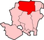 Shown within Hampshire | |
| Geography | |
| Status: | Borough |
| Region: | South East England |
| Admin. County: | Hampshire |
| Area: - Total | Ranked 66th 633.8 km² |
| Admin. HQ: | Basingstoke |
| ONS code: | E07000084 |
| Demographics | |
| Population: - Total (mid-2017 est.) - Density | Ranked 107th 175,300 276 / km² |
| Ethnicity:[1] | 94.7% White 2.1% S.Asian 1.0% Black 1.3% Mixed 1.0% Chinese or other |
| Politics | |
| Basingstoke and Deane Borough Council http://www.basingstoke.gov.uk/ | |
| Leadership: | Leader & Cabinet |
Kingsclere and Whitchurch Rural District is a 1932-established council district that comprised the well-developed rural villages of Kingsclere, Whitchurch and the parishes surrounding them. It was formed in 1932 from two 1894-incorporated rural districts of its two named chief component parts. Its area has become since 1974 wholly part of Basingstoke and Deane district with borough status in the north of Hampshire, England. Basingstoke and Deane Council assumed responsibilities and took over its tax collection functions on 1 April 1974 as well as those of Basingstoke Rural District to its east.[2]
Contents
The civil parishes (and main villages of except where stated):
- ASHMANSWORTH
- BAUGHURST
- BURGHCLERE
- EAST WOODHAY
- ECCHINSWELL AND SYDMONTON
- HIGHCLERE
- HURSTBOURNE PRIORS
- KINGSCLERE
- LAVERSTOKE
- LITCHFIELD AND WOODCOTT
- NEWTOWN
- OVERTON
- ST MARY BOURNE
- TADLEY
- WHITCHURCH[3]
Character
The area had the North Wessex Downs Area of Outstanding Natural Beauty as to its northern half and its widespread chalklands present good-grade arable farmland for staple crops of wheat, barley, oats and maize. It sits at the head of the Test valley, a chalk-fed, high-quality watercourse and the area has a number of bottled water suppliers including of the naturally sparkling variety in its area and small-scale vineyards in the English wine industry. Within the area is Highclere Castle and major villagesbuffered by the rest of their predominantly rural parish land, most populous examples being Tadley, Overton and between 1951-1961 the much-expanded Baughurst.
References
- ↑ Neighbourhood Statistics
- ↑ "England council elections". BBC News Online. Retrieved 3 September 2011.
- ↑ http://www.visionofbritain.org.uk/unit/10026088