Nutley, Hampshire
| Nutley | |
|---|---|
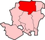
 Nutley Nutley shown within Hampshire | |
| Population | 196 (2011 Census including Farleigh Wallop)[1] |
| OS grid reference | SU5538837410 |
| District | |
| Shire county | |
| Region | |
| Country | England |
| Sovereign state | United Kingdom |
| Post town | BASINGSTOKE |
| Postcode district | SO24 9 |
| Dialling code | 01256 |
| Police | Hampshire |
| Fire | Hampshire |
| Ambulance | South Central |
| EU Parliament | South East England |
| UK Parliament | |
| Website | Preston Candover and Nutley Parish Council |
Nutley is a small village and civil parish in the Basingstoke and Deane district of Hampshire, England. It is located approximately 5.6 miles (9.0 km) south-west from Basingstoke, just off the B3046 road. The parish has an acreage of 1,524 acres (617 ha) with 74 acres (30 ha) made up of permanent grass and 386 acres (156 ha) of woodland.[2]
Governance
The village of Nutley is part of the civil parish of Nutley,[3] which is part of the parish council of Preston Candover and Nutley. It is also part of the Upton Grey and the Candovers ward of Basingstoke and Deane borough council.[4] The borough council is a Non-metropolitan district of Hampshire County Council.
References
- ↑ "Civil Parish population 2011". Neighbourhood Statistics. Office for National Statistics. Retrieved 8 December 2016.
- ↑ "Nutley acreage". Retrieved 27 October 2010.
- ↑ "Hampshire County Council's legal record of public rights of way in Hampshire" (PDF). 2008. Retrieved 27 October 2010.
- ↑ "Basingstoke and Deane Wards info". 2010. Archived from the original on 24 October 2010. Retrieved 27 October 2010.
This article is issued from
Wikipedia.
The text is licensed under Creative Commons - Attribution - Sharealike.
Additional terms may apply for the media files.