Sherfield Park
| Sherfield Park | |
|---|---|
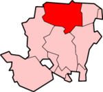
 Sherfield Park Sherfield Park shown within Hampshire | |
| • London | 42.8 miles (69 km) SW |
| District | |
| Shire county | |
| Region | |
| Country | England |
| Sovereign state | United Kingdom |
| Post town | BASINGSTOKE |
| Postcode district | RG27 |
| Dialling code | 01256 |
| Police | Hampshire |
| Fire | Hampshire |
| Ambulance | South Central |
| EU Parliament | South East England |
| UK Parliament | |
Sherfield Park, also known as Taylors Farm, is a civil parish in the Basingstoke and Deane district of Hampshire, England. It is situated about 4 miles (6 km) northeast of central Basingstoke, to the west of the A33 road that runs between Basingstoke and Reading.
The civil parish covers a housing estate that was built between 2004 and 2014 and now has 1,000 dwellings.[1] The greenfield site had until then mainly been part of Taylors Farm, a name which has sometimes been used for the estate.[2] The estate was originally part of the parish of Sherfield on Loddon. Between 2008 and 2016, the area was a ward of this parish which was named Taylors Farm. On 1 April 2016, Sherfield Park was separated to form a parish of its own,[3] with its first parish council being elected a month later. Sherfield Park is in the borough electoral ward of Chineham and the county council division of Loddon.
References
External links
| Wikimedia Commons has media related to Sherfield Park. |