Khislavichsky District
| Khislavichsky District Хиславичский район (Russian) | |
|---|---|
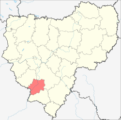 Location of Khislavichsky District in Smolensk Oblast | |
| Coordinates: 54°11′N 32°09′E / 54.183°N 32.150°ECoordinates: 54°11′N 32°09′E / 54.183°N 32.150°E | |
| Location | |
| Country | Russia |
| Federal subject | Smolensk Oblast[1] |
| Administrative structure (as of February 2014) | |
| Administrative center | settlement of Khislavichi[1] |
| Administrative divisions:[1] | |
| Urban settlements | 1 |
| Rural settlements | 11 |
| Inhabited localities:[1] | |
| Urban-type settlements[2] | 1 |
| Rural localities | 148 |
| Municipal structure (as of November 2013) | |
| Municipally incorporated as | Khislavichsky Municipal District[3] |
| Municipal divisions:[3] | |
| Urban settlements | 1 |
| Rural settlements | 11 |
| Statistics | |
| Area (administrative district) (February 2014) | 1,161.00 km2 (448.26 sq mi)[1] |
| Population (2010 Census) | 9,070 inhabitants[4] |
| • Urban | 45.6% |
| • Rural | 54.4% |
| Density | 7.81/km2 (20.2/sq mi)[5] |
| Time zone | MSK (UTC+03:00)[6] |
| Official website | |
| Khislavichsky District on WikiCommons | |
Khislavichsky District (Russian: Хиславичский райо́н) is an administrative[1] and municipal[3] district (raion), one of the twenty-five in Smolensk Oblast, Russia. It is located in the southwest of the oblast and borders with Monastyrshchinsky District in the north, Pochinkovsky District in the east, Shumyachsky District in the south, and with Mstsislaw District of Mogilev Region of Belarus in the west. The area of the district is 1,161 square kilometers (448 sq mi).[1] Its administrative center is the urban locality (an urban-type settlement) of Khislavichi.[1] Population: 9,070 (2010 Census);[4] 12,007 (2002 Census);[7] 15,071 (1989 Census).[8] The population of Khislavichi accounts for 45.6% of the district's total population.[4]
Geography
The whole area of the district belongs to the drainage basin of the Sozh River, a major right tributary of the Dnieper. The Sozh crosses the district from the north to the southwest, crossing into Belarus. The principal tributaries of the Sozh within the district are the Berezina River (left) and the Lyza River (right). Most of the area of the district is flat, and in the northwest the outskirts of the Smolensk Upland dominate the landscape.[9]
History
Since the 12th century, the area belonged to the Principality of Smolensk, and since the end of the 12th century — to its vassal state, the Principality of Mstislavl. Until 1359, it belonged intermittently to the Grand Duchy of Lithuania and to Smolensk lands. After 1359, together with the whole Principality of Mstislavl, it became part of the Grand Duchy of Lithuania, and subsequently of Poland. The Principality of Mstislavl was abolished in 1483, and Khislavichi is first mentioned in 1526. In 1772, as a result of the First Partition of Poland, the area was transferred to Russia and included in the newly established Mogilev Governorate. It belonged to Mstislavsky Uyezd. In 1919, Mogilev Governorate was abolished, and Mstislavsky Uyezd was transferred to Smolensk Governorate. On 3 March 1924, a half of Mstislavsky Uyezd was transferred to Byelorussian Soviet Socialist Republic, and seven volosts, including Khislavichi, were left in Smolensk Governorate.[10]
On 12 July 1929, governorates and uyezds were abolished, and Khislavichsky District with the administrative center in the settlement of Khislavichi was established. The district belonged to Roslavl Okrug of Western Oblast. On August 1, 1930 the okrugs were abolished, and the districts were subordinated directly to the oblast. In 1935, Khislavichi was granted urban-type settlement status.[11] On 27 September 1937 Western Oblast was abolished and split between Oryol and Smolensk Oblasts. Khislavichsky District was transferred to Smolensk Oblast. Between July 1941 and September 1943, during WWII, the district was occupied by German troops.[10][12]
In 1963, during the abortive Khrushchyov administrative reform, Khislavichsky District was merged into Monastyrshchinsky District. In 1965, it was re-established.[12]
Economy
Agriculture
There are 19 farms in the district. The main agricultural specializations are cattle breeding as well as growing of crops and vegetables.[9]
Transportation
Khislavichi is on a main road which connects Pochinok with Mstsislaw, where it continues to Orsha and Krychaw. The road crosses into Belarus west of the village of Oktyabrskoye. In Khislavichi, a road branches northwest to Monastyrshchina. There are also local roads with bus traffic originating from Khislavichi.
The closest railway station is in Pochinok.
The Sozh is not navigable within the district.
Culture and recreation
There are 13 archaeological monuments and 10 cultural monuments in the district, all protected at the local level.[9]
In Khislavichi, there is a local museum.[13]
References
Notes
- 1 2 3 4 5 6 7 8 Resolution #261
- ↑ The count of urban-type settlements may include the work settlements, the resort settlements, the suburban (dacha) settlements, as well as urban-type settlements proper.
- 1 2 3 Law #110-z
- 1 2 3 Russian Federal State Statistics Service (2011). "Всероссийская перепись населения 2010 года. Том 1" [2010 All-Russian Population Census, vol. 1]. Всероссийская перепись населения 2010 года (2010 All-Russia Population Census) (in Russian). Federal State Statistics Service. Retrieved June 29, 2012.
- ↑ The value of density was calculated automatically by dividing the 2010 Census population by the area specified in the infobox. Please note that this value is only approximate as the area specified in the infobox does not necessarily correspond to the area of the entity proper or is reported for the same year as the population.
- ↑ Правительство Российской Федерации. Федеральный закон №107-ФЗ от 3 июня 2011 г. «Об исчислении времени», в ред. Федерального закона №271-ФЗ от 03 июля 2016 г. «О внесении изменений в Федеральный закон "Об исчислении времени"». Вступил в силу по истечении шестидесяти дней после дня официального опубликования (6 августа 2011 г.). Опубликован: "Российская газета", №120, 6 июня 2011 г. (Government of the Russian Federation. Federal Law #107-FZ of June 31, 2011 On Calculating Time, as amended by the Federal Law #271-FZ of July 03, 2016 On Amending Federal Law "On Calculating Time". Effective as of after sixty days following the day of the official publication.).
- ↑ Russian Federal State Statistics Service (May 21, 2004). "Численность населения России, субъектов Российской Федерации в составе федеральных округов, районов, городских поселений, сельских населённых пунктов – районных центров и сельских населённых пунктов с населением 3 тысячи и более человек" [Population of Russia, Its Federal Districts, Federal Subjects, Districts, Urban Localities, Rural Localities—Administrative Centers, and Rural Localities with Population of Over 3,000] (XLS). Всероссийская перепись населения 2002 года [All-Russia Population Census of 2002] (in Russian). Retrieved August 9, 2014.
- ↑ Demoscope Weekly (1989). "Всесоюзная перепись населения 1989 г. Численность наличного населения союзных и автономных республик, автономных областей и округов, краёв, областей, районов, городских поселений и сёл-райцентров" [All Union Population Census of 1989: Present Population of Union and Autonomous Republics, Autonomous Oblasts and Okrugs, Krais, Oblasts, Districts, Urban Settlements, and Villages Serving as District Administrative Centers]. Всесоюзная перепись населения 1989 года [All-Union Population Census of 1989] (in Russian). Институт демографии Национального исследовательского университета: Высшая школа экономики [Institute of Demography at the National Research University: Higher School of Economics]. Retrieved August 9, 2014.
- 1 2 3 "Инвестиционный паспорт" (in Russian). Khislavichsky District Administration. Retrieved 1 July 2017.
- 1 2 "Историческая справка" (in Russian). Khislavichsky District Administration. Retrieved 3 July 2017.
- ↑ "Генеральный план муниципального образования Хиславичского городского поселения" (PDF) (in Russian). Khislavichsky District Administration. p. 36. Retrieved 5 July 2017.
- 1 2 Борис Парфенов; Ольга Хоренженкова. "К истории формирования Смоленской области" (in Russian). Смоленск. Retrieved 18 June 2016.
- ↑ "Хиславичский районный краеведческий музей" (in Russian). Хиславичский районный краеведческий музей. Retrieved 1 July 2017.
Sources
- Администрация Смоленской области. Постановление №261 от 30 апреля 2008 г. «Об утверждении реестра административно-территориальных единиц и территориальных единиц Смоленской области», в ред. Постановления №464 от 27 июня 2014 г. «О внесении изменений в реестр административно-территориальных единиц и территориальных единиц Смоленской области». Опубликован: База данных "Консультант-плюс". (Administration of Smolensk Oblast. Resolution #261 of April 30, 2008 On the Adoption of the Registry of the Administrative-Territorial Units and Territorial Units of Smolensk Oblast, as amended by the Resolution #464 of June 27, 2014 On Amending the Registry of the Administrative-Territorial Units and Territorial Units of Smolensk Oblast. ).
- Смоленская областная Дума. Закон №110-з от 20 декабря 2004 г. «О наделении статусом муниципального района муниципального образования "Хиславичский район" Смоленской области, об установлении границ муниципальных образований, территории которых входят в его состав, и наделении их соответствующим статусом», в ред. Закона №164-з от 26 декабря 2013 г. «О внесении изменений в отдельные областные Законы». Вступил в силу со дня официального опубликования. Опубликован: "Вестник Смоленской областной Думы и Администрации Смоленской области", №13, часть II, стр. 238, 22 декабря 2004 г. (Smolensk Oblast Duma. Law #110-z of December 20, 2004 On Granting the Status of the Municipal District to the Municipal Formation of "Khislavichsky District" of Smolensk Oblast, on Establishing the Borders of the Municipal Formations the Territories of Which It Comprises, and on Granting Them Appropriate Status, as amended by the Law #164-z of December 26, 2013 On Amending Various Oblast Laws. Effective as of the official publication date.).
| Districts | |||
|---|---|---|---|
| Cities and towns | |||
| Urban-type settlements |
| ||