Khemarat District
| Khemarat เขมราฐ | |
|---|---|
| District | |
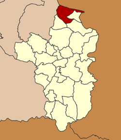 Districtlocation in Ubon Ratchathani Province | |
| Coordinates: 16°2′24″N 105°12′24″E / 16.04000°N 105.20667°ECoordinates: 16°2′24″N 105°12′24″E / 16.04000°N 105.20667°E | |
| Country | Thailand |
| Province | Ubon Ratchathani |
| Area | |
| • Total | 525.1 km2 (202.7 sq mi) |
| Population (2005) | |
| • Total | 77,010 |
| • Density | 146.7/km2 (380/sq mi) |
| Time zone | UTC+7 (ICT) |
| Postal code | 34170 |
| Geocode | 3405 |
Khemarat (Thai: เขมราฐ) is the northernmost district (amphoe) of Ubon Ratchathani Province, northeastern Thailand.
History
Mueang Khemarat is an ancient city. It was a first class city in the Rattanakosin Kingdom and reported directly to Bangkok. During the Thesaphiban reforms at the beginning of the 20th century it became subordinate to Ubon Ratchathani.
Geography
Neighboring districts are (from the southeast clockwise) Na Tan, Pho Sai, and Kut Khaopun of Ubon Ratchathani Province, Pathum Ratchawongsa and Chanuman of Amnat Charoen Province. To the northeast across the Mekong River is the Laotian province of Salavan.
The important water resource is the Mekong River.
Administration
The district is divided into nine sub-districts (tambons), which are further subdivided into 117 villages (mubans). Khemarat itself is a township (thesaban tambon) which covers parts of the tambon Khemarat. There are a further nine tambon administrative organizations (TAO).
| No. | Name | Thai name | Villages | Pop. | |
|---|---|---|---|---|---|
| 1. | Khemarat | เขมราฐ | 19 | 16,987 | |
| 3. | Kham Pom | ขามป้อม | 17 | 9,288 | |
| 4. | Chiat | เจียด | 9 | 4,858 | |
| 7. | Nong Phue | หนองผือ | 13 | 9,243 | |
| 8. | Na Waeng | นาแวง | 12 | 7,052 | |
| 10. | Kaeng Nuea | แก้งเหนือ | 10 | 6,253 | |
| 11. | Nong Nok Tha | หนองนกทา | 13 | 5,764 | |
| 12. | Nong Sim | หนองสิม | 10 | 4,908 | |
| 13. | Hua Na | หัวนา | 14 | 12,657 |
Missing numbers belong to tambon which now form Na Tan District.