Khong Chiam District
| Khong Chiam โขงเจียม | |
|---|---|
| District | |
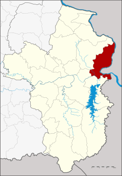 District location in Ubon Ratchathani Province | |
| Coordinates: 15°19′8″N 105°29′44″E / 15.31889°N 105.49556°ECoordinates: 15°19′8″N 105°29′44″E / 15.31889°N 105.49556°E | |
| Country | Thailand |
| Province | Ubon Ratchathani |
| Seat | Khong Chiam |
| Area | |
| • Total | 765.0 km2 (295.4 sq mi) |
| Population (2005) | |
| • Total | 32,693 |
| • Density | 32.7/km2 (85/sq mi) |
| Time zone | UTC+7 (ICT) |
| Postal code | 34220 |
| Geocode | 3403 |
Khong Chiam (Thai: โขงเจียม, pronounced [kʰǒːŋ t͡ɕīa̯m]) is the easternmost district (amphoe) of Ubon Ratchathani Province of Thailand.
History
The area of the district was the central district khwaeng of Mueang Khong Chiam, which is now Si Mueang Mai District. On 1 January 1957 the three tambons Khong Chiam, Huai Yang, and Pho Klang were split off from Khong Chiam to form the Ban Dan minor district (king amphoe).[1] On 11 December 1959 it was elevated to a full district.[2]
On 14 September 1971 the district was renamed "Khong Chiam", while the former district Khong Chiam was renamed "Si Mueang Mai", as the historical center of Mueang Khong Chiam was in this district.[3]
Assumed that the term "Khong Chiam" comes from the word "khong" (โขง) meaning "chief of elephants" or "a herd of elephants" (khlong; โขลง in Thai) and "chiam" (เจียม) from the word "chiang" (เจียง), which means 'tribute'. Overall, it can be meaning 'city with elephants live together in large herds'.[4]
Geography
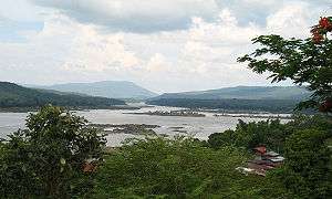
Neighboring districts are (from the south clockwise) Sirindhorn, Phibun Mangsahan and Si Mueang Mai. To the east across the Mekong river are the Laotian provinces of Salavan and Champasak.
Khong Chiam is the easternmost point of Thailand.
The Pak Mun Dam stops the Mun River before it empties into the Mekong River in this district.
Also the Kaeng Tana and Pha Taem national parks are in Khong Chiam District.
Administration
The district is divided into five sub-districts (tambons), which are further subdivided into 50 villages (mubans). The township (thesaban tambon) Ban Dan covers parts of tambon Khong Chiam. There are a further five tambon administrative organizations (TAO).
| No. | Name | Thai name | Villages | Pop. | |
|---|---|---|---|---|---|
| 1. | Khong Chiam | โขงเจียม | 14 | 8,039 | |
| 2. | Huai Yang | ห้วยยาง | 9 | 7,457 | |
| 3. | Na Pho Klang | นาโพธิ์กลาง | 9 | 6,895 | |
| 4. | Nong Saeng Yai | หนองแสงใหญ่ | 9 | 5,104 | |
| 5. | Huai Phai | ห้วยไผ่ | 9 | 5,198 |
References
- ↑ ประกาศกระทรวงมหาดไทย เรื่อง ย้ายที่ว่าการอำเภอโขงเจียม และตั้งกิ่งอำเภอบ้านด่าน จังหวัดอุบลราชธานี (PDF). Royal Gazette (in Thai). 74 (8 ง): 225–226. January 22, 1957.
- ↑ พระราชกฤษฎีกาตั้งอำเภอชุมพวง อำเภอเชียงยืน อำเภอแก้งคร้อ อำเภอสำโรงทาบ อำเภอคอนสาร อำเภอเซกา อำเภอทุ่งเสลี่ยม อำเภอบ้านด่าน อำเภอขนอม อำเภอบ้านแพรก อำเภอกระทู้ และอำเภอคลองใหญ่ พ.ศ. ๒๕๐๒ (PDF). Royal Gazette (in Thai). 76 (113 ก special): 8–11. December 10, 1959.
- ↑ พระราชกฤษฎีกาเปลี่ยนชื่ออำเภอบางแห่งในจังหวัดอุบลราชธานี พ.ศ. ๒๕๑๔ (PDF). Royal Gazette (in Thai). 88 (98 ก): 618–620. September 14, 1971.
- ↑ "อำเภอโขงเจียม". The Office of Academic Resources Ubon Ratchathani University (in Thai).
| Wikimedia Commons has media related to Khong Chiam District. |
External links