Na Tan District
| Na Tan นาตาล | |
|---|---|
| District | |
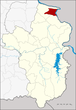 Districtlocation in Ubon Ratchathani Province | |
| Coordinates: 15°54′18″N 105°16′36″E / 15.90500°N 105.27667°ECoordinates: 15°54′18″N 105°16′36″E / 15.90500°N 105.27667°E | |
| Country | Thailand |
| Province | Ubon Ratchathani |
| Seat | Na Tan |
| Area | |
| • Total | 191.9 km2 (74.1 sq mi) |
| Population (2005) | |
| • Total | 34,735 |
| • Density | 181.0/km2 (469/sq mi) |
| Time zone | UTC+7 (ICT) |
| Postal code | 34170 |
| Geocode | 3430 |
Na Tan (Thai: นาตาล, pronounced [nāː tāːn]) is a district (amphoe) in the northeastern part of Ubon Ratchathani Province, northeastern Thailand.
History
Na Tan area was separated from Khemarat District to create a minor district (king amphoe) on 30 April 1994.[1]
On 15 May 2007, all 81 minor districts were upgraded to full districts.[2] On 24 August the upgrade became official.[3]
Geography
Neighboring districts are (from the south clockwise) Pho Sai and Khemarat. To the east across the Mekong River is the Laotian province of Salavan.
The important water resource is the Mekong.
Administration
The district is divided into four sub-districts (tambons), which are further subdivided into 64 villages (mubans). There are no municipal (thesaban) areas, and four tambon administrative organizations (TAO).
| No. | Name | Thai name | Villages | Pop. | |
|---|---|---|---|---|---|
| 1. | Na Tan | นาตาล | 19 | 10,725 | |
| 2. | Phalan | พะลาน | 14 | 6,046 | |
| 3. | Kong Phon | กองโพน | 13 | 7,165 | |
| 4. | Phang Khen | พังเคน | 18 | 10,799 |
References
- ↑ ประกาศกระทรวงมหาดไทย เรื่อง แบ่งเขตท้องที่อำเภอเขมราฐ จังหวัดอุบลราชธานี ตั้งเป็นกิ่งอำเภอนาตาล (PDF). Royal Gazette (in Thai). 111 (42 ง): 18. May 26, 1994.
- ↑ แถลงผลการประชุม ครม. ประจำวันที่ 15 พ.ค. 2550 (in Thai). Manager Online.
- ↑ พระราชกฤษฎีกาตั้งอำเภอฆ้องชัย...และอำเภอเหล่าเสือโก้ก พ.ศ. ๒๕๕๐ (PDF). Royal Gazette (in Thai). 124 (46 ก): 14–21. August 24, 2007.
External links