Khammam Fort
| Khammam Fort | |
|---|---|
| Kammamet | |
| Part of Stambhadri Hills | |
| Khammam, Telangana, India | |
 Khammam Fort Location in Telangana | |
| Coordinates | 17°14′43″N 80°08′48″E / 17.24528°N 80.14667°ECoordinates: 17°14′43″N 80°08′48″E / 17.24528°N 80.14667°E |
| Type | Hill Fort |
| Height | 867 metres (2,844 ft) |
| Site information | |
| Owner | Government of India |
| Controlled by |
Kakatiya Kings 950 A. D. - 1323 A. D. Musunuri Kamma Kings 1325 A. D. - 1428 A. D. Bahamani Sultans 1428 A. D. - 1470 A. D Gajapati Kingdom 1470 A. D. - 1497 A. D. Chittap Khan 1497 A. D. - 1512 A. D. Independent rulers 1512 A. D. -1515 A.D Sri Krishnadevaraya of Tuluva Dynasty 1515 A.D for a brief period Qutb Shahi dynasty 1518 A.D - 1687 A.D Mughal Empire 1687 A.D - 1707 A.D Asaf Jahi Dynasty 1707 A.D-1948 A.D |
| Open to the public | Yes |
| Condition |
Declared Protected Monument by Archaeological Survey of India in 2005. Mostly Destroyed. |
| Site history | |
| Built by | Musunuri Kamma Kings |
| In use | Tourism |
| Materials | Stone, Lime stone mortar |
| Battles/wars | Kakatiyas, Musunuri Kamma Kings, Qutub Shahis, Aurangazeb, Sri Krishnadevaraya and Local Rulers |
| Events | Stambhadri Sambaralu,1000 Year Celebrations of Khammam Khilla |
| Garrison information | |
| Occupants |
Kakatiya Kings 950 A. D. - 1323 A. D. Musunuri Kamma Kings - 1325 A. D. - 1428 A. D. Bahamani Sultans 1443 A. D. - 1470 A. D Gajapati Kingdom 1470 A. D. - 1497 A. D. Chittap Khan 1497 A. D. - 1512 A. D. Krishna Deva Raya of Tuluva Dynasty, Shitab Khan - 1515 A.D - 1518 A.D Qutb Shahi dynasty- 1518 A.D - 1687 A.D Aurangazeb of the Mughal Empire - 1687 A.D - 1707 A.D Asaf Jahi Dynasty - 1707 - 1948 A.D |
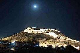
Khammam Fort is a fort in the city of Khammam, Telangana, India constructed by Musunuri Kamma Kings. It served as an impregnable citadel during various regimes of different dynasties, including the Qutb Shahi’s and Asaf Jahis. The fort was situated in a very vast area in the heart of the City of Khammam. It was notified as a protected monument by the Archaeology Department several decades ago. Despite decades of neglect, the historical edifice, which once flourished with regal opulence, presents its alluring charm due to its architectural splendor.
Etymology
The historical records show that the name was "Kammamet."[1][2][3][4][5][6] Mett or Mettu means fort in Telugu language.
Construction
Kammamet was built by Musunuri Kings. Several inscriptions were discovered in the surrounding areas of Khammam and Krishna districts of Musunuri Kings dating back to 10th and 11th century A.D.[7]
Kammamet slowly became an independent territory within the kingdom of Kakatiya Kings for Musunuri Kings.
75 Telugu speaking feudatories of the region under the leadership of Musunuri Kings fought for 10 long years to unify the Telugu land and succeeded in repulsing them out of country.
Architecture & Significant Features
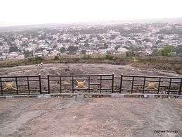
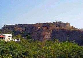
- This Fort is located in an area of 4 Sq. miles in the heart of the City of Khammam on top of a massive granite Hill. It is surrounded by a huge rock wall averaging between 40 and 80 feet(13 to 25 Meters) in height and 15 to 20 feet(4.5 to 6 Meters) in width. There are steps from each buruju (bastion) to enter into the fort. The Fort was considered practically impregnable by invading armies.
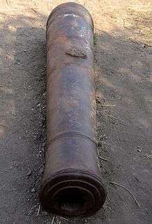
- A number of balconies and windows are constructed along the wall in order to use the artillery during wartime. It has a capacity of mounting at least 60 cannons at a time.
- The fort 10 large gates most of them in poor shape now. Each gate has cannons mounted on them along with a water pot made of rocks. They are built such that an impact of a cannonball could not break it.
- The main entrance is a 30 foot tall entrance known as the Khilla darwaza(meaning fort gate in Urdu). It has 2 cannons on either side of the entrance. One of them still mounted with a head. They are now partially destroyed due to the negligence of the archeology department.
- The east gate or the secondary entrance is equally large and is popularly known as the Raathi Darwaza(meaning stone entrance in Urdu) or Potha Darwaza.
- All other gates are smaller than the main entrance and could have been constructed to avoid large cavalries to enter the fort in case of an attack.
- A huge rainwater catchment system and well have been constructed on the Khilla during the period of Zafar-ud-doula, well known for construction of tanks during Qutb shahi dynasty. This massive tank is now known as the ‘Zafar well’. It is 60 feet X 30 feet stepped well with a bridge across it for men and horses to move around. He also built the walls using Bricks and limestone along the fort.
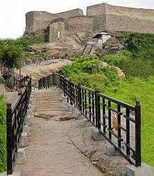
- As soon as we enter the Khilla darwaza, one can see the Fort at a distance of 300 feet. There are small steps carved out of this hill to reach the top of the Hill fort. They are later renovated with railings for the steps by the Tourism department and Archaeological Survey of India in 2005 during the 1000 year celebrations of this historical fort. A lot of small gates known as ‘Dalohiswar’ are all around the walls of the fort.
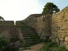
- Fort has at least 15 bastions constructed with two massive walls as a military strategy to take the impact of the cannonballs and to counter the enemy from the top. A 15 foot deep trench is dug in some places for the army to store and use as a hiding place.
- The huge blocks of stone used for the walls are as long as 10 feet and are believed to be transported using elephants and men. No mud or limestone is used in this huge wall and the rocks are tightly placed and leaving the viewers amazed by the construction
- A permanent Gallows has been erected on this prominent hill fort, where the estimated seat of justice could have been inside the fort. The platform is made of Stone and appears like a well, due to which the locals call this 'Nethi bhavi' ('నేతి బావి 'meaning Ghee well).This stone structure could be seen from allover the city of khammam.
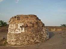 Stone Gallows, locally believed to be a Ghee well on top of the fort
 - The fort is believed to have a secret tunnels to the Warangal Fort with multiple entrances in different locations at the fort. One such entrance is 10 feet in diameter and the steps to enter the tunnel are closed due to damage over the years. The local folklore includes stories about valuables being transferred between the kings from here using the secret passages and escaping enemy attacks through them.[8]
Culture
This Fort appears to be a replicate the cultures of both Hindu and Muslim rulers who ruled this fort city.
The Lakshmi Narasimha swami temple in Brahmin bazar, Sri Ramalingeshwara temple is one of the oldest shivalayam(Shiva temple) are some of the oldest Hindu temples in Telangana and are older than the fort itself.
During the Qutb shahi dynasty, many new places of worship have been constructed in and around the fort such as the Khilla masjid.
Encroachments
The fort, once mighty bastion of royal dynasties, continues to face further encroachment threat due to lack of proper monitoring mechanism.Large settlements occupied the areas in and around the fort due to the lack of proper monitoring of encroachments. Destruction of the granite hill and construction of houses continues till today around the fort area.
Development
The historic Khammam fort, a living testimony to the majestic grandeur and architectural marvel of the bygone era, is poised to get a face lift with the government departments drawing up grand plans to beautify and develop the majestic edifice.Illumination of the fort, including installation of solar streetlights atop the fort, introduction of the sound and light show at the historical edifice and development of a park at the entrance of the fort, are some of the initiatives in the pipeline.With the Telangana government laying renewed focus on the historical edifices of architectural significance, the government departments turned their attention on beautifying the Khammam fort and safeguarding the protected monument from future encroachments.A proposal to develop a park and set up a canteen besides illuminating the fort at an estimated cost of Rs. 5 crore has already been submitted to the government, says Suman Chakravarthi, District Tourism Officer, Khammam. The plan also envisages provision of amenities and introduction of sound and light show at the fort on the lines of the Golconda Fort in Hyderabad, he elaborates.A plan is on the anvil to install solar streetlights at the fort, says G. S. V. Prasad, District Manager, New and Renewable Energy Development Corporation.Recently Minister for Roads & Buildings Tummala Nageswara Rao has mooted the proposal to set up solar streetlights at the fort well before the next Independence Day celebrations in 2017.[9]
| Wikimedia Commons has media related to Khammam Fort. |
See also
References
- ↑ A Descriptive and Historical Account of the Godavery District in the Presidencyof Madras, H. Morris, 1878, London, p. 216
- ↑ A manual of the Kistna district in the presidency of Madras, Gordon Mackenzie, 1883, Madras, p. 25, 80
- ↑ Buddhist remains in Āndhra and the history of Āndhra between 224 & 610 A.D., K. R. Subramanian, p. 149
- ↑ A Handbook for India, Part I, Madras, John Murray, 1859, London
- ↑ The Geography of India, J. Burgess, 1871, London, p. 48
- ↑ The Church Missionary Intelligencer, Volume 2,1866, London, p. 73
- ↑ Inscription of Musunuri Gundaya, 11th century, Bapatla, Kaifiat of Baptla
- ↑ "Khammam Fort: Heritage in peril". 2015-01-29. Retrieved 2016-07-09.
- ↑ "Historic Khammam fort set to get back its sheen". The Hindu. 2015-01-30. ISSN 0971-751X. Retrieved 2016-07-09.
http://www.thehindu.com/news/national/telangana/khammam-fort-heritage-in-peril/article6835132.ece