Kfar Warburg
| Kfar Warburg | |
|---|---|
 Kfar Warburg | |
 Kfar Warburg | |
| Coordinates: 31°43′10.55″N 34°43′23.51″E / 31.7195972°N 34.7231972°ECoordinates: 31°43′10.55″N 34°43′23.51″E / 31.7195972°N 34.7231972°E | |
| District | Southern |
| Council | Be'er Tuvia |
| Affiliation | Moshavim Movement |
| Founded | 31 October 1939 |
| Founded by | "Menachem" members |
| Population (2017)[1] | 1,130 |
| Website | www.kfar-warburg.org |
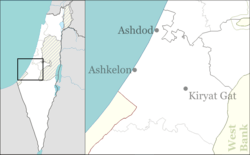
Kfar Warburg (Hebrew: כְּפַר וַרְבּוּרְג, lit. Warburg Village) is a large moshav in south-central Israel. Located near Kiryat Malakhi with 98 farms covering an area of 6,000 dunams, it falls under the jurisdiction of Be'er Tuvia Regional Council. In 2017 it had a population of 1,130.[1]
History
The moshav was founded on 31 October 1939 by members of the "Menachem" organisation. It was named after Felix M. Warburg, one of the leaders of the Jewish community in the United States and a founder of the American Jewish Joint Distribution Committee.[2] It was founded on land that had traditionally belonged to the depopulated Palestinian village of Qastina.[3]
Notable residents include Yigal Hurvitz, a former Minister of Finance, who was buried in the moshav.
References
- 1 2 "List of localities, in Alphabetical order" (PDF). Israel Central Bureau of Statistics. Retrieved August 26, 2018.
- ↑ Mapa's concise gazetteer of Israel (in Hebrew). Yuval El'azari (ed.). Tel-Aviv: Mapa Publishing. 2005. p. 285. ISBN 965-7184-34-7.
- ↑ Khalidi, Walid (1992). All That Remains: The Palestinian Villages Occupied and Depopulated by Israel in 1948. Washington D.C.: Institute for Palestine Studies. p. 131. ISBN 0-88728-224-5. ISBN 0-88728-224-5.
External links
| Wikimedia Commons has media related to Kfar Warburg. |
- Official website (in Hebrew)