Kennett Square Historic District
|
Kennett Square Historic District | |
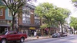 Kennett Square Historic District, May 2007 | |
  | |
| Location | Roughly bounded by Sickles, Willow, Mullberry, Broad, South, Union, Cedar, Lafayette, State, and Washington, Kennett Square, Pennsylvania |
|---|---|
| Coordinates | 39°50′41″N 75°42′44″W / 39.84472°N 75.71222°WCoordinates: 39°50′41″N 75°42′44″W / 39.84472°N 75.71222°W |
| Area | 137 acres (55 ha) |
| Built | 1855 |
| Architect | Multiple |
| Architectural style | Colonial Revival, Late Victorian, Federal |
| NRHP reference # | 89001052[1] |
| Added to NRHP | August 18, 1989 |
Kennett Square Historic District is a national historic district located in Kennett Square, Chester County, Pennsylvania. It encompasses 507 contributing buildings in the central business district and surrounding residential areas of Kennett Square. They are mostly residential and commercial structures built between 1875 and 1924 and in a variety of popular architectural styles including Colonial Revival, Victorian, and Federal. Notable non-residential buildings include the American Road Machinery complex, Kennett Consolidated School, New Century Club, Baptist church, St. Patrick's Parochial School, former Episcopal Church of the Advent, Friends Home, Bernard Building, and Municipal Building.[2]
It was added to the National Register of Historic Places in 1989.[1]
References
- 1 2 National Park Service (2010-07-09). "National Register Information System". National Register of Historic Places. National Park Service.
- ↑ "National Historic Landmarks & National Register of Historic Places in Pennsylvania" (Searchable database). CRGIS: Cultural Resources Geographic Information System. Note: This includes Priscilla M. Thompson (May 1989). "National Register of Historic Places Registration Form: Kennett Square Historic District" (PDF). Retrieved 2012-12-23.
| Topics |   | |
|---|---|---|
| Lists by county |
| |
| Lists by city | ||
| Other lists | ||
| ||