Kaunakakai, Hawaii
| Kaunakakai, Hawaii | |
|---|---|
| Census-designated place | |
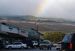 Downtown Kaunanakai, July 2006 | |
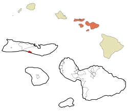 Location in Maui County and the state of Hawaii | |
| Coordinates: 21°5′20″N 157°0′45″W / 21.08889°N 157.01250°WCoordinates: 21°5′20″N 157°0′45″W / 21.08889°N 157.01250°W | |
| Country | United States |
| State | Hawaii |
| County | Maui |
| Area | |
| • Total | 16.4 sq mi (42.6 km2) |
| • Land | 12.8 sq mi (33.2 km2) |
| • Water | 3.6 sq mi (9.4 km2) |
| Elevation | 20 ft (6 m) |
| Population (2010) | |
| • Total | 3,425 |
| • Density | 210/sq mi (80/km2) |
| Time zone | UTC-10 (Hawaii-Aleutian) |
| ZIP code | 96748 |
| Area code(s) | 808 |
| FIPS code | 15-31100 |
| GNIS feature ID | 0360717 |
Kaunakakai is a census-designated place (CDP) in Maui County, Hawaiʻi, United States. It is the largest town on the island of Molokaʻi. The population was 3,425 at the 2010 census.[1] It has the largest port on the island and the longest pier in Hawaii.[2] The town was made famous in the 1930s by the song "The Cockeyed Mayor of Kaunakakai", beginning an ongoing tradition of designating an honorary mayor for the town.[3]
History
In the mid-1800s, King Kamehameha V sometimes spent his summers on Molokai at a home in Kaunakakai. The main street of Kaunakakai, Ala Malama Avenue, was named after the king's summer home.[4]
Geography
Kaunakakai is located at 21°5′20″N 157°0′45″W / 21.08889°N 157.01250°W (21.088968, -157.012542).[5]
According to the United States Census Bureau, the CDP has a total area of 16.4 square miles (42.6 km2), of which 12.8 square miles (33.2 km2) is land and 3.6 square miles (9.4 km2), or 22.00%, is water.[6]
Climate
Kaunakakai has a tropical savannah (As) climate.
| Climate data for Kaunakakai, Hawaii | |||||||||||||
|---|---|---|---|---|---|---|---|---|---|---|---|---|---|
| Month | Jan | Feb | Mar | Apr | May | Jun | Jul | Aug | Sep | Oct | Nov | Dec | Year |
| Average high °F (°C) | 78 (26) |
78 (26) |
79 (26) |
80 (27) |
82 (28) |
83 (28) |
85 (29) |
86 (30) |
86 (30) |
85 (29) |
82 (28) |
79 (26) |
82 (28) |
| Average low °F (°C) | 63 (17) |
63 (17) |
64 (18) |
65 (18) |
67 (19) |
69 (21) |
70 (21) |
71 (22) |
71 (22) |
70 (21) |
68 (20) |
65 (18) |
67 (20) |
| Average precipitation inches (mm) | 3.7 (94) |
3.7 (94) |
2.5 (64) |
2.1 (53) |
1.4 (36) |
0.7 (18) |
0.6 (15) |
0.6 (15) |
0.8 (20) |
1.8 (46) |
2.8 (71) |
4.0 (102) |
24.7 (628) |
| Source: Weatherbase[7] | |||||||||||||
Demographics
As of the census[8] of 2010, there were 3,425 people, 1,254 households, and 850 families residing in the CDP. The population density was 1,342.7 people per square mile (518.5/km²). There were 1,533 housing units at an average density of 473.8 per square mile (183.0/km²). The racial makeup of the CDP was 15.4% White, 0.5% Black, 0.3% Native American, 22.2% Asian (of whom 15.5% were Filipino), 22.4% Native Hawaiian, 0.3% from other races, and 37.4% from two or more races. Hispanic or Latino of any race were 5.9% of the population.
There were 1,254 households out of which 24.6% had children under the age of 18 living with them, 46.3% were married couples living together, 15.7% had a female householder with no husband present, and 33.2% were non-families. 22.5% of all households were made up of individuals under 18 years and 27% of households had someone living alone. The average household size was 2.73 and the average family size was 3.32.
As of the census of 2000, in the CDP the population was spread out with 31.8% under the age of 18, 8.3% from 18 to 24, 22.6% from 25 to 44, 21.6% from 45 to 64, and 15.2% who were 65 years of age or older. The median age was 36 years. For every 100 females, there were 91.8 males. For every 100 females age 18 and over, there were 88.3 males.
The median income for a household in the CDP was $34,492, and the median income for a family was $39,348. Males had a median income of $30,543 versus $22,337 for females. The per capita income for the CDP was $14,201. About 15.5% of families and 20.6% of the population were below the poverty line, including 27.4% of those under age 18 and 11.8% of those age 65 or over.
References
- ↑ "Profile of General Population and Housing Characteristics: 2010 Demographic Profile Data (DP-1): Kaunakakai CDP, Hawaii". U.S. Census Bureau, American Factfinder. Retrieved December 28, 2011.
- ↑ GoHawaii Retrieved 14 July 2017.
- ↑ The Molokai Times
- ↑ "Hawaii Vacation Travel Guide: Kaunakakai, Molokai".
- ↑ "US Gazetteer files: 2010, 2000, and 1990". United States Census Bureau. 2011-02-12. Retrieved 2011-04-23.
- ↑ "Geographic Identifiers: 2010 Demographic Profile Data (G001): Kaunakakai CDP, Hawaii". U.S. Census Bureau, American Factfinder. Retrieved December 28, 2011.
- ↑ "Weatherbase: Historical Weather for Molokai,". Weatherbase. 2011. Retrieved on November 24, 2011.
- ↑ "American FactFinder". United States Census Bureau. Retrieved 2017-07-11.
External links

Honolulu (capital) | ||
| Topics | ||
| Society | ||
| Main islands | ||
| Northwestern Islands | ||
| Communities | ||
| Counties | ||
| Sovereignty Movement | ||
Islands, municipalities, and communities of Maui County, Hawaii, United States | ||
|---|---|---|
| CDPs |  | |
| Unincorporated communities | ||
| Footnotes | ‡This populated place also has portions in an adjacent county or counties | |