Kashmore District
| Kashmore District ضلعو ڪشمور | |
|---|---|
| District | |
 | |
| Coordinates: 28°21′N 69°23′E / 28.350°N 69.383°ECoordinates: 28°21′N 69°23′E / 28.350°N 69.383°E | |
| Country | Pakistan |
| Province | Sindh |
| Headquarters | Kandhkot |
| Area | |
| • Total | 2,592 km2 (1,001 sq mi) |
| Population (2017)[1] | |
| • Total | 1,089,169 |
| • Density | 420/km2 (1,100/sq mi) |
| Time zone | UTC+5 (PST) |
| Number of Tehsils | 3 |
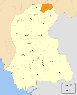
Kashmore District (Sindhi: ضلو ڪشمور), (Urdu: ضِلع کشمور), previously known as Khizmer or Khizmore, is a district of the province of Sindh, Pakistan. The capital city is Kandhkot which has a population of District Kashmore 1,206,772. Kashmoor Kandkot is part of Larkana division. Its old name was Khizmer or Khizmor. While the district headquarter is Kandkot city. Kashmoor Kandkot district was created in 2004. Before this it was part of Jacobabad district. The total population of district Kashmoor Kandkot was 1207000 persons in 2011. Total area of district is 255 square kilometers. The spoken languages are Sindhi 40% and Balochi 60%. Its border is connected with Punjab and Balochistan provinces. Kashmoor city is gateway to Punjab province and Balochistan province. [2]
In 2004, Kashmore District was separated from Jacobabad District.
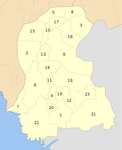
Administrative divisions
Kashmor District is subdivided into three tehsils:
list of union councils of distt kashmore Union Council No. Union Council Name and Area UC No. 1 Line Purani Taluka Kashmoor UC No. 2 Khoski Taluka Kashmore UC No. 3 Masowalo Taluka Kahmore UC No. 4 Domiwali Taluka Kahmore UC No. 5 Geehal pur Taluka Kahmore UC No. 6 Gullan pur Taluka Kahmore UC No. 7 Sodhi Taluka Kahmore UC No. 8 Noor Pur Pako Taluka Kahmore UC No. 9 Chachar Taluka Kahmore UC No. 10 Badani Taluka Kahmore UC No. 11 Gublo Taluka Kahmore UC No. 12 Mahar Taluka Kahmore UC No. 13 Toj Taluka Kahmore UC No. 14 Kumb Taluka Kahmore UC No. 15 Samao Taluka Kahmore UC No. 16 Kumbiri Taluka Kahmore UC No. 17 Zorgrah Taluka Kahmore UC No. 18 Mulgulzar Taluka Kandhkot UC No. 19 Rasaldar Taluka Kandhkot UC No. 20 Jagirabad Taluka Kandhkot UC No. 21 Dolat Pur Taluka Kandhkot UC No. 22 Wakro Taluka Kandhkot UC No. 23 Akhero Taluka Kandhkot UC No. 24 Malheer Taluka Kandhkot UC No. 25 Haibat Taluka Kandhkot UC No. 26 Dadar Taluka Kandhkot UC No. 27 Mangi Taluka Kandhkot UC No. 28 Jaffar Abad Taluka Tangwani UC No. 29 Cheel Taluka Tangwani UC No. 30 Lashari Taluka Tangwani UC No. 31 Bijarani Taluka Tangwani UC No. 32 Suhliani Taluka Tangwani UC No. 33 Manjhi Taluka Tangwani UC No. 34 Gulwali Taluka Tangwani UC No. 35 Saifal Taluka Tangwani UC No. 36 SaidoKot Taluka Tangwani UC No. 37 Karam pur Taluka Tangwani UC No. 38 Sher Garh Taluka Tangwani UC No. 39 Dunyapur Taluka Tangwani UC No. 40 Naseer Taluka Tangwani UC No. 41 Bahalkani Taluka Tangwani
Agriculture
Kashmor District has a large cattle market.
Geography
Kashmor District is located in the northern part of Sindh, bordering Ghotki, Jacobabad, Shikarpur and Sukkur within Sindh. It also borders Balochistan on one side and Punjab on the other. The Indus river runs through the Eastern side of Kashmor district. The southeastern side of Kashmor District has forest of "Kacha" that support wild animals. The Thar desert falls on the Eastern side of the district, and is home to wild desert animals.
Demography
According to the 1998 census, Sindhi was the first language of 95% of the population of the talukas of Kashmore and Kandhkot, while Balochi accounted for 2.7%.[3]
Kashmor City
Kandhkot is the district headquarters of Kashmor, and also an old city that lies on the right side of the Indus river. Kashmore City is a gateway to Punjab Pakistan and Balochistan. The city has a population of 312,500. In addition, the city’s main electricity comes from the Indus river.
References
- ↑ "DISTRICT WISE CENSUS RESULTS CENSUS 2017" (PDF). www.pbscensus.gov.pk. Archived from the original (PDF) on 2017-08-29.
- ↑ "Sindh population surges by 81.5 pc, households by 83.9 pc". Thenews.com.pk. 2 April 2012. Retrieved 2016-12-26.
- ↑ PCO 1999, p. 111–12.
Bibliography
- 1998 District census report of Jacobabad. Census publication. 17. Islamabad: Population Census Organization, Statistics Division, Government of Pakistan. 1999.