Kardaritsi
| Kardaritsi Καρδαρίτσι | |
|---|---|
 | |
 Kardaritsi | |
| Coordinates: 37°49′N 21°51′E / 37.817°N 21.850°ECoordinates: 37°49′N 21°51′E / 37.817°N 21.850°E | |
| Country | Greece |
| Administrative region | Peloponnese |
| Regional unit | Arcadia |
| Municipality | Gortynia |
| Municipal unit | Kontovazaina |
| Elevation | 900 m (3,000 ft) |
| Community[1] | |
| • Population | 41 (2011) |
| Time zone | UTC+2 (EET) |
| • Summer (DST) | UTC+3 (EEST) |
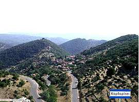
Kardaritsi (Greek: Καρδαρίτσι) is a mountain village in the municipal unit of Kontovazaina in northwest Arcadia, Greece. It is situated on a ridge above the left bank of the river Erymanthos. It is 5 km northwest of Kontovazaina, 6 km southeast of Lampeia (Divry), 9 km southwest of Psofida (Tripotama) and 50 km south of Patras. Historical records trace the existence of the village back to the 18th century. The village has a church dedicated to Saint Nicholas and an impressive cold water spring named “Trani Vrisi” that feeds the village's reservoir.
Population
| Year | 1700 | 1861 | 1889 | 1907 | 1920 | 1928 | 1940 | 1951 | 1961 | 1971 | 1988 | 2001 | 2011 |
|---|---|---|---|---|---|---|---|---|---|---|---|---|---|
| Population | 85 | 344 | 445 | 489 | 468 | 455 | 410 | 354 | 336 | 191 | 100 | 108 | 41 |
Gallery
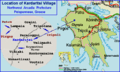 Map:Village Location
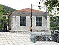 Village School
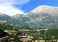 View from South - Mount Afrodisio (Ρούσσιο)
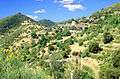 View from Northeast
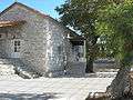 Saint Nicholas Church
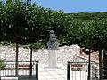 Village Square - Kolokotronis Statue
References
- ↑ "Απογραφή Πληθυσμού - Κατοικιών 2011. ΜΟΝΙΜΟΣ Πληθυσμός" (in Greek). Hellenic Statistical Authority.
- ↑ Η Ιστορία ενός χωριού - Καρδαρίτσι (in Greek)
External links
This article is issued from
Wikipedia.
The text is licensed under Creative Commons - Attribution - Sharealike.
Additional terms may apply for the media files.