Lampeia
| Lampeia Λάμπεια | |
|---|---|
_general_view.jpg) | |
 Lampeia Location within the regional unit 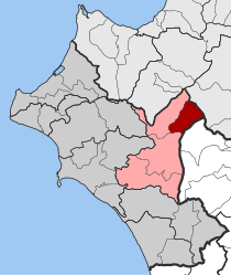 | |
| Coordinates: 37°51′N 21°48′E / 37.850°N 21.800°ECoordinates: 37°51′N 21°48′E / 37.850°N 21.800°E | |
| Country | Greece |
| Administrative region | West Greece |
| Regional unit | Elis |
| Municipality | Archaia Olympia |
| • Municipal unit | 72.4 km2 (28.0 sq mi) |
| Elevation | 803 m (2,635 ft) |
| Population (2011)[1] | |
| • Municipal unit | 1,000 |
| • Municipal unit density | 14/km2 (36/sq mi) |
| Community[1] | |
| • Population | 529 (2011) |
| Time zone | UTC+2 (EET) |
| • Summer (DST) | UTC+3 (EEST) |
| Postal code | 270 63 |
| Area code(s) | 26240 |
| Vehicle registration | ΗΑ |
_partial_view_1.jpg)
_partial_view_2.jpg)
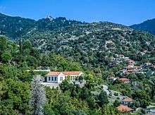
Lampeia (Greek: Λάμπεια, before 1928: Δίβρη - Divri,[2] between 1928 and 1929: Πρινόφυτον - Prinofyton[3]) is a mountain village, a community and a former municipality in Elis, West Greece, Greece. Since the 2011 local government reform it is part of the municipality Archaia Olympia, of which it is a municipal unit.[4] The municipal unit has an area of 72.447 km2.[5] In 2011 the population of the village was 468, and of the community, which includes the village Amygdali, 529.
Lampeia is situated south of Mount Erymanthos, in the valley of a tributary of the river Erymanthos. Its elevation is about 800 m above sea level.[6] The Greek National Road 33 (Patras - Tripoli) passes through it. Lampeia is 4 km west of Oreini, 9 km northeast of Koumanis, 28 km northeast of Olympia and 45 km south of Patras.
Subdivisions
The municipal unit Lampeia is subdivided into the following communities (constituent villages in brackets):
Population
| Year | Village | Community | Municipality |
|---|---|---|---|
| 1981 | - | 757 | - |
| 1991 | 576 | - | 1,243 |
| 2001 | 661 | 764 | 1,374 |
| 2011 | 468 | 529 | 1,000 |
History
The name Lampeia was taken from the mountain Lampeia, which is part of the Erymanthos range. According to Pausanias the river Erymanthos has its source on the mountain Lampeia, which is sacred to Pan. The area was part of Arcadia.[7] Due to its inaccessibility, Lampeia saw few invaders. Also the Ottomans stayed in the lower areas for strategic reasons. The Zoodochos Pigi monastery in Lampeia was a centre of Greek culture and education. Several inhabitants fought in the Greek War of Independence, and some well known families of politicians (Petralias, Panagoulis, Stefanopoulos, Zafeiropoulos) came from Divri/Lampeia.
Lampeia was created as one of the eight municipalities of the Elis prefecture in the 1830s, and was disbanded in 1913. This municipality was larger than the present municipal unit, and included several villages now in adjacent municipal units (among others Koumanis, Antroni and Klindia). The municipality was recreated under the Capodistrian Plan in the late-1990s, and became a subdivision of the municipality of Archaia Olympia in 2011.
Notable people
- Pavlos Matesis,[8] writer
See also
References
- 1 2 "Απογραφή Πληθυσμού - Κατοικιών 2011. ΜΟΝΙΜΟΣ Πληθυσμός" (in Greek). Hellenic Statistical Authority.
- ↑ Name changes of settlements in Greece
- ↑ Name changes of settlements in Greece
- ↑ Kallikratis law Greece Ministry of Interior (in Greek)
- ↑ "Population & housing census 2001 (incl. area and average elevation)" (PDF) (in Greek). National Statistical Service of Greece. Archived from the original (PDF) on 2015-09-21.
- ↑ GTP travel page
- ↑ Pausanias, Description of Greece 8.24.4
- ↑ Επίτομο Γεωγραφικό Λεξικό της Ελλάδος (Geographical Dictionary of Greece), Μιχαήλ Σταματελάτος, Φωτεινή Βάμβα-Σταματελάτου, εκδ. Ερμής, ΑΘήνα 2001
External links
- MyDivri.gr A great site with news, photos and historical information on Divri (Δίβρη)/Lambia (Λαμπεία) (in Greek and English)
- Antroni - Labeia (in Greek)
- Video from the ERT program Traveling in Greece (Menoume Ellada) shown on ET1
Places adjacent to Lampeia | ||||||||||
|---|---|---|---|---|---|---|---|---|---|---|
| ||||||||||