Wakasa, Tottori
| Wakasa 若桜町 | ||
|---|---|---|
| Town | ||
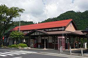
 View of Wakasa | ||
| ||
 Location of Wakasa in Tottori Prefecture | ||
 Wakasa Location in Japan | ||
| Coordinates: 35°20′N 134°24′E / 35.333°N 134.400°ECoordinates: 35°20′N 134°24′E / 35.333°N 134.400°E | ||
| Country | Japan | |
| Region |
Chūgoku San'in | |
| Prefecture | Tottori Prefecture | |
| District | Yazu | |
| Area | ||
| • Total | 199.31 km2 (76.95 sq mi) | |
| Population (October 1, 2016 est.) | ||
| • Total | 3,209 | |
| • Density | 16/km2 (42/sq mi) | |
| Time zone | UTC+9 (JST) | |
| Website |
www | |


Wakasa (若桜町 Wakasa-chō) is a town located in Yazu District, Tottori Prefecture, Japan.[1]
As of 2016, the town has an estimated population of 3,209 and a density of 16 persons per km². The total area is 199.31 square kilometres (76.95 sq mi).[2][3] Wakasa, located deep in the Chūgoku Mountains, is 95% mountainous. The population of Wakasa is primarily located in mountain villages in a line from the southeast to northwest of the town. Most of the population is located along the Hattō River or its small tributaries.[1]
The town hosts an annual 'Yukigassen', an organised snowball fighting tournament in which up to fifty teams participate. The winners win a trip to participate in the Hokkaido grand tournament.
Geography
Wakasa is largely rural and located centrally in the Chūgoku Mountains. Prominent mountains in the town include Mount Hyōno(1,509.6 metres (4,953 ft)), Mount Mimuro (1,358 metres (4,455 ft)), Ōginosen (1,309.9 metres (4,298 ft)), and Mount Shinbachi (1,207 metres (3,960 ft)). The area of the town along the border with Hyōgo Prefecture is part of Hyōnosen-Ushiroyama-Nagisan Quasi-National Park.
The Hattō River (39.1 kilometres (24.3 mi)), the largest tributary of the Sendai River, emerges from Tokura Ridge on the border of Wakasa and Shisō, Hyōgo Prefecture. The Hattō flows from the southwest foot of Mount Hyōno through the town and joins the Sendai in the Kawaramachi area of Tottori City.[4]
Bordering municipalities
Wakasa, while located in Tottori Prefecture, borders Hyōgo and Okayama prefectures.
History
Early history
The mountainous areas of Wakasa do not appear to have supported a population in early Japanese history. No remains from the Jōmon (14,000 – 300 BCE) or Yayoi 300 BCE – 250 CE) periods have been found in Wakasa.[1] The town had two or three small settlements in the Kofun period (250 – 538). Wakasa became part of Yakami District in Inaba Province early in recorded Japanese history. Settlements in the area are appeared early in the Heian period (794 – 1185), and the name of a village called Wakasa first appear in the historical record this time. The Yabe clan controlled Wakasa throughout the Heian period to the end of the Kamakura period (1185 – 1333). The Yabe built Oniga Castle in this period.A The existence of the Yabe clan and Oniga castle are noted in the Taiheiki, a Japanese historical epic written in the late 14th century.[1][5][6][7]
Later history
Wakasa, located in a richly forested area of the Chūgoku Mountains, was a source of lumber and lumber products from early times. The production of raw timber, planks, charcoal, and firewood is noted as early as the Kamakura period. These products, as well as rice, were transported on the Hattō River for export to other parts of Japan via the Japan Sea. At the beginning of the Edo period (1603 – 1868) the Tokugawa shogunate developed land for rice paddies in Wakasa as part of a nationwide effort to increase rice production in Japan. The mountainous areas of Wakasa provided extensive irrigation for rice-producing areas in the flatlands of the lower Sendai River, but Wakasa suffered frequent flooding from the Hattō River, notably in 1815 and 1888.[2][4] After the Meiji Restoration in 1868 Wakasa became part of the newly formed Tottori Prefecture. The town was officially incorporated under administrative reforms by the Meiji government in 1889.[1][7]
Economy
Wakasa has historically been a center of the lumber trade, but is now also known for its production of daikon radish and other agricultural products.[2]
Footnotes
References
- 1 2 3 4 5 6 "若桜町" [Wakasa]. Nihon Rekishi Chimei Taikei (in Japanese). Tokyo: Shogakukan. 2012. OCLC 173191044. dlc 2009238904. Retrieved 2012-07-21.
- 1 2 3 4 "若桜(町)" [Wakasa]. Nihon Daihyakka Zensho (Nipponika) (in Japanese). Tokyo: Shogakukan. 2012. OCLC 153301537. Retrieved 2012-07-30.
- ↑ 人口世帯数 [Population and Household Count] (in Japanese). Wakasa, Tottori Prefecture: Town of Wakasa. 2012. Retrieved July 21, 2012.
- 1 2 "八東川" [Hattō River]. Nihon Rekishi Chimei Taikei (in Japanese). Tokyo: Shogakukan. 2012. OCLC 173191044. dlc 2009238904. Retrieved 2012-07-21.
- ↑ "八上郡" [Yakami District]. Kokushi Daijiten (in Japanese). Tokyo: Shogakukan. 2012. OCLC 683276033. Retrieved 2012-07-21.
- ↑ "鬼ヶ城跡" [Oniga Castle Remains]. Nihon Rekishi Chimei Taikei (in Japanese). Tokyo: Shogakukan. 2012. OCLC 173191044. dlc 2009238904. Retrieved 2012-07-21.
- 1 2 町のおいたち [Town History] (in Japanese). Wakasa, Tottori Prefecture: Town of Wakasa. 2012. Retrieved July 21, 2012.
- ↑ Nihon Rekishi Chimei Taikei (in Japanese). Tokyo: Shogakukan. 2012. OCLC 173191044. dlc 2009238904. Retrieved 2012-07-21.
External links

- Wakasa official website (in Japanese)
| Core city | ||
|---|---|---|
| Cities | ||
| Districts | ||