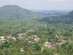
Kalutara District
| Kalutara District කඵතර දිස්ත්රික්කය களுத்துறை மாவட்டம் | |
|---|---|
| Administrative District | |
 | |
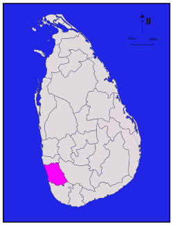 Location within Sri Lanka | |
| Coordinates: 06°35′N 80°10′E / 6.583°N 80.167°ECoordinates: 06°35′N 80°10′E / 6.583°N 80.167°E | |
| Country | Sri Lanka |
| Province | Western |
| Capital | Kalutara |
| DS Division | |
| Government | |
| • District Secretary | U. D. C. Jayalal |
| Area[1] | |
| • Total | 1,598 km2 (617 sq mi) |
| • Land | 1,576 km2 (608 sq mi) |
| • Water | 22 km2 (8 sq mi) 1.38% |
| Area rank | 20th (2.44% of total area) |
| Population (2012 census)[2] | |
| • Total | 1,217,260 |
| • Rank | 5th (6.01% of total pop.) |
| • Density | 760/km2 (2,000/sq mi) |
| Ethnicity(2012 census)[2] | |
| • Sinhalese | 1,054,991 (86.67%) |
| • Sri Lankan Moors | 112,276 (9.22%) |
| • Sri Lankan Tamil | 24,362 (2.00%) |
| • Indian Tamil | 23,611 (1.94%) |
| • Other | 2,020 (0.17%) |
| Religion(2012 census)[3] | |
| • Buddhist | 1,016,632 (83.52%) |
| • Muslim | 114,422 (9.40%) |
| • Christian | 46,109 (3.79%) |
| • Hindu | 39,773 (3.27%) |
| • Other | 324 (0.03%) |
| Time zone | UTC+05:30 (Sri Lanka) |
| Post Codes | 12000-12999 |
| Telephone Codes | 034, 038 |
| ISO 3166 code | LK-13 |
| Vehicle registration | WP |
| Official Languages | Sinhala, Tamil |
| Website | Kalutara District Secretariat |
Kalutara District (Sinhalese: කඵතර දිස්ත්රික්කය; Tamil: களுத்துறை மாவட்டம் Kaḷuttuṟai Māvaṭṭam) is one of the 25 districts of Sri Lanka, the second level administrative division of the country. The district is administered by a District Secretariat headed by a District Secretary (previously known as a Government Agent) appointed by the central government of Sri Lanka. The capital of the district is the town of Kalutara.
Geography
Kalutara District is located in the south west of Sri Lanka and has an area of 1,598 square kilometres (617 sq mi).[1] It is bounded by Colombo District from north, Ratnapura District from east, Galle District from south, and by the Indian Ocean from west.[4]
Administrative units
Kalutara District is divided into 14 Divisional Secretary's Division (DS Divisions), each headed by a Divisional Secretary (previously known as an Assistant Government Agent).[5] The DS Divisions are further sub-divided into 762 Grama Niladhari Divisions (GN Divisions).[5]
| DS Division | Main Town | Divisional Secretary | GN Divisions [5] |
Area (km2) [6] |
Population (2012 Census)[7] | Population Density (/km2) | |||||
|---|---|---|---|---|---|---|---|---|---|---|---|
| Sinhalese | Sri Lankan Moors | Sri Lankan Tamil | Indian Tamil | Other | Total | ||||||
| Agalawatta | Agalawatta | H. A. K. Pushpakumara | 34 | 88 | 35,456 | 71 | 102 | 810 | 17 | 36,456 | 414 |
| Bandaragama | Bandaragama | M. A. T. Senarath | 59 | 56 | 96,032 | 11,887 | 364 | 378 | 228 | 108,889 | 1,944 |
| Beruwala | Beruwala | Janaka Sri Chandaguptha | 82 | 69 | 105,351 | 56,741 | 1,543 | 666 | 206 | 164,507 | 2,384 |
| Bulathsinhala | Bulathsinhala | Irangani Weerasinghe | 54 | 206 | 54,635 | 2,223 | 4,236 | 3,513 | 28 | 64,635 | 314 |
| Dodangoda | Dodangoda | Thilanka Wettasinha | 45 | 114 | 56,405 | 35 | 3,636 | 3,583 | 46 | 63,705 | 559 |
| Horana | Horana | K. A. D. R. N. Jayasinghe | 61 | 109 | 110,122 | 94 | 698 | 1,329 | 198 | 112,441 | 1,032 |
| Ingiriya | Ingiriya | Champa Upasena | 31 | 90 | 48,155 | 13 | 1,978 | 3,452 | 47 | 53,645 | 596 |
| Kalutara | Kalutara | Wimal Gunathunga | 87 | 69 | 144,457 | 12,428 | 1,844 | 159 | 337 | 159,225 | 2,308 |
| Madurawela | Madurawela | Menaka Priyantha Abeyrathna | 33 | 59 | 31,345 | 9 | 506 | 2,363 | 22 | 34,245 | 580 |
| Matugama | Matugama | W. S. M. K. Silva | 57 | 128 | 70,612 | 2,819 | 5,325 | 2,209 | 99 | 81,064 | 633 |
| Millaniya | Millaniya | Wimal Gunathunga | 44 | 81 | 50,465 | 41 | 80 | 1,461 | 31 | 52,078 | 643 |
| Palindanuwara | Baduraliya | Tharani Anoja Gamage | 43 | 276 | 45,492 | 577 | 1,755 | 2,548 | 10 | 50,382 | 183 |
| Panadura | Panadura | K. G. Wijayasiri | 72 | 44 | 153,840 | 25,328 | 1,556 | 263 | 737 | 181,724 | 4,130 |
| Walallavita | Walallavita | Dashitha Niroshana | 60 | 209 | 52,624 | 10 | 739 | 877 | 14 | 54,264 | 260 |
| Total | 762 | 1,598 | 1,054,991 | 112,276 | 24,362 | 23,611 | 2,020 | 1,217,260 | 762 | ||
Demographics
Population
Kalutara District's population was 1,217,260 in 2012.[2] The majority of the population are Sinhalese, with a minority Sri Lankan Moor and Sri Lankan Tamil population.
Ethnicity
| Year | Sinhalese | Sri Lankan Moors | Sri Lankan Tamil | Indian Tamil | Other | Total No. | |||||
|---|---|---|---|---|---|---|---|---|---|---|---|
| No. | % | No. | % | No. | % | No. | % | No. | % | ||
| 1946 Census | n/a | n/a | n/a | n/a | n/a | n/a | n/a | n/a | n/a | n/a | 456,572 |
| 1953 Census | n/a | n/a | n/a | n/a | n/a | n/a | n/a | n/a | n/a | n/a | 523,550 |
| 1963 Census | n/a | n/a | n/a | n/a | n/a | n/a | n/a | n/a | n/a | n/a | 631,457 |
| 1971 Census | n/a | n/a | n/a | n/a | n/a | n/a | n/a | n/a | n/a | n/a | 729,514 |
| 1981 Census | 723,483 | 87.20% | 61,159 | 7.37% | 9,744 | 1.17% | 33,659 | 4.06% | 1,659 | 0.20% | 829,704 |
| 2001 Census | 928,914 | 87.12% | 93,293 | 8.75% | 12,665 | 1.19% | 28,895 | 2.71% | 2,472 | 0.23% | 1,066,239 |
| 2012 Census | 1,054,991 | 86.67% | 112,276 | 9.22% | 24,362 | 2.00% | 23,611 | 1.94% | 2,020 | 0.17% | 1,217,260 |
Religion
Religion in Kalutara District (2011)[10]
| Year | Buddhist | Muslim | Christian[lower-alpha 1] | Hindu | Other | Total No. | |||||
|---|---|---|---|---|---|---|---|---|---|---|---|
| No. | % | No. | % | No. | % | No. | % | No. | % | ||
| 1981 Census | 699,613 | 84.32% | 62,659 | 7.55% | 30,121 | 3.63% | 37,035 | 4.46% | 276 | 0.03% | 829,704 |
| 2001 Census | 883,968 | 82.91% | 105,957 | 9.94% | 41,214 | 3.87% | 34,678 | 3.25% | 422 | 0.04% | 1,066,239 |
| 2012 Census | 1,016,632 | 83.52% | 114,422 | 9.40% | 46,109 | 3.79% | 39,773 | 3.27% | 324 | 0.03% | 1,217,260 |
See also
Notes
- ↑ Roman Catholic and Other Christian.
References
- 1 2 "Area of Sri Lanka by province and district" (PDF). Statistical Abstract 2011. Department of Census & Statistics, Sri Lanka. Archived from the original (PDF) on 2012-11-13.
- 1 2 3 4 "A2 : Population by ethnic group according to districts, 2012". Census of Population & Housing, 2011. Department of Census & Statistics, Sri Lanka.
- 1 2 "A3 : Population by religion according to districts, 2012". Census of Population & Housing, 2011. Department of Census & Statistics, Sri Lanka.
- ↑ "Overview". Kalutara District Secretariat.
- 1 2 3 "Grama Niladhari Divisions". Kalutara District Secretariat.
- ↑ "Land area by province, district and divisional secretariat division" (PDF). Statistical Abstract 2011. Department of Census & Statistics, Sri Lanka. Archived from the original (PDF) on 2012-11-13.
- ↑ "A6 : Population by ethnicity and district according to Divisional Secretary's Division, 2012". Census of Population & Housing, 2011. Department of Census & Statistics, Sri Lanka.
- ↑ "Census of Population Sri Lanka 1971 - General Report". Census of Population & Housing, 1971. Department of Census & Statistics, Sri Lanka. p. 29.
- ↑ "Population by ethnic group and district, Census 1981, 2001" (PDF). Statistical Abstract 2011. Department of Census & Statistics, Sri Lanka. Archived from the original (PDF) on 2013-12-15.
- ↑ Department of Census and Statistics,The Census of Population and Housing of Sri Lanka-2011
- ↑ "Population by religion and district, Census 1981, 2001" (PDF). Statistical Abstract 2011. Department of Census & Statistics, Sri Lanka. Archived from the original (PDF) on 2012-11-13.
External links
| Wikimedia Commons has media related to Kalutara District. |