Kaike
| Kaike काईके गाउँपालिका | |
|---|---|
| Rural Municipality | |
 Kaike Location in Nepal | |
| Coordinates: 28°50′N 83°04′E / 28.84°N 83.06°ECoordinates: 28°50′N 83°04′E / 28.84°N 83.06°E | |
| Country |
|
| Province | Karnali Pradesh |
| District | Dolpa |
| Wards | 7 |
| Established | 10 March 2017 |
| Government | |
| • Type | Rural Council |
| Area | |
| • Total | 466.6 km2 (180.2 sq mi) |
| Population (2011) | |
| • Total | 3,576 |
| • Density | 7.7/km2 (20/sq mi) |
| Time zone | UTC+5:45 (NST) |
| Headquarter | Sahartara |
| Website |
kaikemun |
Kaike (Nepali: काईके गाउँपालिका) is a rural municipality located in Dolpa District of Karnali Province of Nepal.[1][2][3]
The rural municipality is divided into total 7 wards and the headquarters of the rural municipality is situated at Sahartara.
References
- ↑ "स्थानीय तहहरुको विवरण (Details of local levels)". www.mofald.gov.np/en. Ministry of Federal Affairs and General Administration. Retrieved 2 October 2018.
- ↑ "Final District 1-75 Corrected Last for RAJPATRA" (PDF). Retrieved 2 October 2018.
- ↑ "Kaike Rural Municipality in Nepal". CITY POPULATION. Retrieved 2 October 2018.
External links
Headquarters: Dunai (today part of Thuli Bheri Municipality) | ||
| Municipalities | 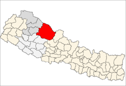 | |
| Rural municipalities | ||
| Former VDCs | ||
List of municipalities and rural municipalities of Nepal | ||
This article is issued from
Wikipedia.
The text is licensed under Creative Commons - Attribution - Sharealike.
Additional terms may apply for the media files.