Kai, Yamanashi
| Kai 甲斐市 | |||
|---|---|---|---|
| City | |||
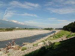 Shingen Embankment and Kamanashi River | |||
| |||
 Location of Kai in Yamanashi | |||
 Kai | |||
| Coordinates: 35°39′38.9″N 138°30′56.8″E / 35.660806°N 138.515778°ECoordinates: 35°39′38.9″N 138°30′56.8″E / 35.660806°N 138.515778°E | |||
| Country | Japan | ||
| Region | Chūbu (Tōkai) | ||
| Prefecture | Yamanashi Prefecture | ||
| Area | |||
| • Total | 71.95 km2 (27.78 sq mi) | ||
| Population (November 1, 2012) | |||
| • Total | 73,993 | ||
| • Density | 1,030/km2 (2,700/sq mi) | ||
| Time zone | UTC+9 (Japan Standard Time) | ||
| Phone number | 055-276-2111 | ||
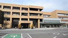
| Address | 2610 Shinohara, Kai-shi, Yamanashi 400-0395 | ||
| Website | http://www.city.kai.yamanashi.jp/ | ||


Kai (甲斐市 Kai-shi) is a city located in Yamanashi Prefecture, Japan.
As of November 2015, the city had an estimated population of 73,993, and a population density of 1,030 persons per km². The total area is 71.95 square kilometres (27.78 sq mi).
Geography
Kai is located in central Yamanashi Prefecture, orientated north-south along the banks of the Fuji River.
Surrounding municipalities
Yamanashi Prefecture
History
The city of Kai was established on September 1, 2004, from the merger of the town of Futaba (from Kitakoma District), and the towns of Ryūō and Shikishima (both from Nakakoma District). It takes its name from the old name for Yamanashi Prefecture, Kai Province.
Education
Kai has eleven elementary schools, five middle schools and one high school.
Transportation
Railway
Highway
Sister city relations

Notable people
- Shin Nakagomi – professional baseball player
- Youichi Imamura – professional racecar driver
References
- ↑ "International Exchange". List of Affiliation Partners within Prefectures. Council of Local Authorities for International Relations (CLAIR). Retrieved 21 November 2015.
External links
![]()
- Official Website (in Japanese)
| Special city | ||
|---|---|---|
| Cities | ||
| Districts | ||