Fujikawaguchiko, Yamanashi
| Fujikawaguchiko 富士河口湖町 | |||
|---|---|---|---|
| Town | |||
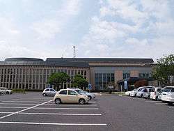 Fujikawaguchiko town hall | |||
| |||
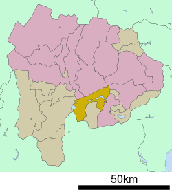 Location of Fujikawaguchiko in Yamanashi Prefecture | |||
 Fujikawaguchiko | |||
| Coordinates: 35°29′50.1″N 138°45′17.8″E / 35.497250°N 138.754944°ECoordinates: 35°29′50.1″N 138°45′17.8″E / 35.497250°N 138.754944°E | |||
| Country | Japan | ||
| Region |
Chūbu Tōkai | ||
| Prefecture | Yamanashi Prefecture | ||
| District | Minamitsuru | ||
| Area | |||
| • Total | 158.40 km2 (61.16 sq mi) | ||
| Population (November 1, 2015) | |||
| • Total | 25,742 | ||
| • Density | 163/km2 (420/sq mi) | ||
| Time zone | UTC+9 (Japan Standard Time) | ||
| Symbols | |||
| • tree | Japanese red pine | ||
| • Flower | Oenothera | ||
| • Bird | Varied tit | ||
| Phone number | 0555-72-1111 | ||
| Address | 1700 Funatsu, Fujikawaguchiko-mach Minimitsuru-gun, Yamanashi-ken 401-0392 | ||
| Website | http://www.town.fujikawaguchiko.lg.jp/ | ||


Fujikawaguchiko (富士河口湖町 Fujikawaguchiko-machi) is a town located in Yamanashi Prefecture, Japan. As of November 2015, the town had an estimated population of 25,742, and a population density of 162 persons per km2.[1] The total area is 158.40 square kilometres (61.16 sq mi).
Geography
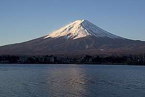
Fujikawaguchiko is located in southern Yamanashi Prefecture, in the foothills of Mount Fuji and shares Lake Kawaguchi, one of the Fuji Five Lakes, with neighboring Minobu. It is the town with the highest elevation in Japan.
Neighboring municipalities
- Yamanashi Prefecture
- Shizuoka Prefecture
Climate
Fujikawaguchiko features a humid continental climate (Köppen Dfa, bordering on Dfb) that closely borders on a humid subtropical climate (Köppen Cfa) and an oceanic climate (Köppen Cfb).
| Climate data for Fujikawaguchiko, Japan (1981-2010) | |||||||||||||
|---|---|---|---|---|---|---|---|---|---|---|---|---|---|
| Month | Jan | Feb | Mar | Apr | May | Jun | Jul | Aug | Sep | Oct | Nov | Dec | Year |
| Average high °C (°F) | 5.3 (41.5) |
6.1 (43) |
9.7 (49.5) |
15.9 (60.6) |
19.9 (67.8) |
22.6 (72.7) |
26.5 (79.7) |
27.6 (81.7) |
23.3 (73.9) |
17.8 (64) |
13.3 (55.9) |
8.4 (47.1) |
16.4 (61.5) |
| Daily mean °C (°F) | −0.6 (30.9) |
0.2 (32.4) |
3.6 (38.5) |
9.3 (48.7) |
13.9 (57) |
17.4 (63.3) |
21.3 (70.3) |
22.1 (71.8) |
18.4 (65.1) |
12.4 (54.3) |
7.1 (44.8) |
2.0 (35.6) |
10.6 (51.1) |
| Average low °C (°F) | −6.2 (20.8) |
−5.2 (22.6) |
−1.7 (28.9) |
3.3 (37.9) |
8.5 (47.3) |
13.2 (55.8) |
17.5 (63.5) |
18.0 (64.4) |
14.6 (58.3) |
7.9 (46.2) |
1.7 (35.1) |
−3.4 (25.9) |
5.7 (42.2) |
| Average precipitation mm (inches) | 54.6 (2.15) |
57.4 (2.26) |
102.2 (4.024) |
105.0 (4.134) |
123.7 (4.87) |
161.9 (6.374) |
162.7 (6.406) |
249.9 (9.839) |
252.9 (9.957) |
176.9 (6.965) |
78.6 (3.094) |
42.4 (1.669) |
1,568.2 (61.742) |
| Average snowfall cm (inches) | 33 (13) |
30 (11.8) |
26 (10.2) |
4 (1.6) |
0 (0) |
0 (0) |
0 (0) |
0 (0) |
0 (0) |
0 (0) |
0 (0) |
8 (3.1) |
101 (39.7) |
| Average relative humidity (%) | 62 | 63 | 67 | 68 | 73 | 80 | 81 | 80 | 82 | 80 | 73 | 65 | 73 |
| Mean monthly sunshine hours | 204.0 | 181.8 | 176.1 | 181.9 | 170.3 | 123.3 | 143.2 | 164.0 | 116.7 | 136.6 | 161.1 | 196.4 | 1,955.4 |
| Source: [2] | |||||||||||||
History
The area around Lake Kawaguchi has been inhabited since at least the Jōmon period. It was on the road connecting Kai Province with Suruga Province, and is mentioned in Heian period records, which also document an eruption of Mount Fuji in 864 AD. During the Edo period, all of Kai Province was tenryō territory under direct control of the Tokugawa shogunate. During the cadastral reform of the early Meiji period in July 1, 1889, the area came under the jurisdiction of Minamitsuru District, Yamanashi Prefecture.
On 15 November 2003, the town of Kawaguchiko, and the villages of Katsuyama and Ashiwada merged to form the new town of Fujikawaguchiko. On 1 March 2006, Fujikawaguchiko absorbed parts of the village of Kamikuishiki, from Nishiyatsushiro District.
Education
- Health Science University
- Fujikawaguchiko has ten elementary schools, five middle schools and one high school
Transportation
Railway
The area is served by the privately operated Fujikyuko Line, with stations at Fujikyu-Highland and Kawaguchiko.
Highway
Local attractions
- Fuji Five Lakes
- The sound of wild birds at Lake Sai was designated as one of the 100 Soundscapes of Japan by the Ministry of the Environment[3]
References
- ↑ 統計で見る富士河口湖町. Fujikawaguchiko official website (in Japanese). Fujikawaguchiko Town.
- ↑ "気象庁 平年値(年・月ごとの値)". Japan Meteorological Agency.
- ↑ "100 Soundscapes of Japan". Ministry of the Environment. Retrieved 8 December 2015.
External links
![]()
- Official Website (in Japanese)
| Special city | ||
|---|---|---|
| Cities | ||
| Districts | ||