Kafr Dariyan
| Kafr Dariyan كفردريان | |
|---|---|
| Village | |
 Kafr Dariyan | |
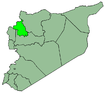
| Coordinates: 36°10′22″N 36°39′54″E / 36.17278°N 36.66500°E | |
| Country |
|
| Governorate | Idlib |
| District | Harem |
| Subdistrict | al-Dana |
| Population (2004)[1] | |
| • Total | 3,580 |
| Time zone | UTC+2 (EET) |
| • Summer (DST) | UTC+3 (EEST) |
Kafr Dariyan (Arabic: كفردريان also spelled Kfar Drian) is a village in Syria, administratively part of Idlib Governorate. It is situated on the northern slopes of the Harim Mountains. Nearby localities include Sarmada to the east, Killi to the south, Qurqania to the southwest and Barisha to the west. According to the Syria Central Bureau of Statistics (CBS), Kafr Dariyan had a population of 3,580 in 2004.[1]
References
- 1 2 General Census of Population and Housing 2004 Archived 2012-12-20 at Archive.is. Syria Central Bureau of Statistics (CBS). Idlib Governorate. Archived at . (in Arabic)
This article is issued from
Wikipedia.
The text is licensed under Creative Commons - Attribution - Sharealike.
Additional terms may apply for the media files.