K-2 (Kansas highway)
| ||||
|---|---|---|---|---|
 | ||||
| Route information | ||||
| Maintained by KDOT | ||||
| Length | 61.516 mi[1] (99.000 km) | |||
| Major junctions | ||||
| West end |
| |||
| East end |
| |||
| Location | ||||
| Counties | Barber, Harper, Kingman, Sumner | |||
| Highway system | ||||
| ||||

K-2 is a state highway in the south-central portion of the U.S. state of Kansas. Its southwestern terminus is at its intersection with U.S. Highway 281 east of Hardtner. Its northeastern terminus is at its intersection with K-42 west of the unincorporated town of Suppesville. It is 54.6 miles (87.9 km) long.[2]
Route description
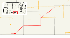
From its western terminus in Barber County, K-2 proceeds east for 5 miles (8.0 km) to the town of Kiowa, where it forms the northern terminus of the brief southern leg of K-8. In Kiowa, K-2 turns to the north and then to the northeast, running parallel to a BNSF Railway track for about 12 miles (19 km), skirting the town of Hazelton and crossing into Harper County. K-2 then runs eastward for about 17 miles (27 km) to Anthony, where it forms the western terminus of K-44 and turns northward. Six miles north of Anthony, K-2 intersects with US-160, which it overlaps for the next four miles (6 km). Three miles north of that intersection, K-2/US-160 turn to the east, through the town of Harper. On the eastern edge of Harper, US-160 continues east, while K-2 goes north and then northeast. It continues northeast for 18 miles (29 km), clipping the southeast corner of Kingman County and crossing briefly into Sumner County, where it ends at K-42 near Suppesville.[3]
History
K-2 was originally designated in 1927 from Norton to Colorado.[4] In 1932, this became part of US 36.[5] The current K-2 was designated in 1937 from US 160 to K-42.[6] In 1963, K-2 was extended in both directions, concurrent with K-14 to US-281 and K-42 to US-54. In 1994, the concurrency with K-42 became K-42 only, and the concurrency with K-14 became K-2 only.
Junction list
| County | Location | mi[1] | km | Destinations | Notes | |||
|---|---|---|---|---|---|---|---|---|
| Barber | | 0.000 | 0.000 | Western terminus | ||||
| Kiowa | 4.511 | 7.260 | Northern terminus of K-8 | |||||
| Harper | Anthony | 33.666 | 54.180 | Western terminus of K-44 | ||||
| | 39.700 | 63.891 | Western terminus of US-160 concurrency | |||||
| Harper | 42.715 | 68.743 | Southern terminus of K-14 | |||||
| 43.827 | 70.533 | Eastern terminus of US-160 concurrency | ||||||
| Kingman |
No major junctions | |||||||
| Sumner | | 61.516 | 99.000 | Eastern terminus | ||||
1.000 mi = 1.609 km; 1.000 km = 0.621 mi
| ||||||||
References
- 1 2 Staff (2016). "Pavement Management Information System". Kansas Department of Transportation. Retrieved April 21, 2017.
- ↑ Kennedy, Richie. "Routelog". Kansas Highways 7.0. Archived from the original on September 27, 2007. Retrieved August 12, 2007.
- ↑ Official Transportation Map (PDF) (Map) (2007-08 ed.). Kansas Department of Transportation. Retrieved August 12, 2007.
- ↑ https://www.davidrumsey.com/luna/servlet/detail/RUMSEY~8~1~33758~1171474:Kansas-. Missing or empty
|title=(help) - ↑ (PDF) http://www.ksdot.org/Assets/wwwksdotorg/bureaus/burTransPlan/maps/HistoricStateMaps/1932Mapside.pdf. Missing or empty
|title=(help) - ↑ http://dmsweb.ksdot.org/AppNetProd/docpop/pdfpop.aspx?KT142_0_0_0=003706836&clienttype=html&doctypeid=114. Missing or empty
|title=(help)