K-13 (Kansas highway)
| ||||
|---|---|---|---|---|
 | ||||
| Route information | ||||
| Maintained by KDOT | ||||
| Length | 14.617 mi (23.524 km) | |||
| Major junctions | ||||
| South end |
| |||
| North end |
| |||
| Location | ||||
| Counties | Riley, Pottawatomie | |||
| Highway system | ||||
| ||||

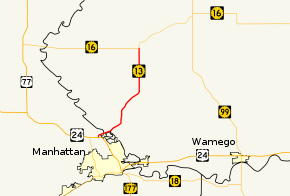
K-13 is a 14.62-mile-long (23.53 km) state highway in the northeastern part of the US state of Kansas. It connects Manhattan to K-16, and serves as the only northeasterly route out of Manhattan. The majority of the highway is exclusively in Pottawatomie County, with less than a mile of it existing in Riley County. The first two miles (3.2 km) traverse Tuttle Creek State Park, and crosses the Tuttle Creek Lake dam.
History
K-13 was once much longer, connecting Manhattan to El Dorado. In 1965, K-177 took over this portion. There was also a former alignment on the west side of the river (eastern Riley county line) before the creation of the lake that served towns before they had been flooded by the dam project.[1]
Gallery
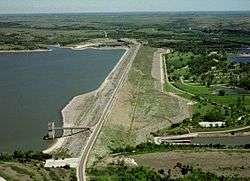
K-13 crosses the dam at Tuttle Creek Lake
Major junctions
| County | Location | mi[2][3] | km | Destinations | Notes |
|---|---|---|---|---|---|
| Riley | | 0.000 | 0.000 | Southern terminus; road continues as Dam Road | |
| Tuttle Creek Lake | 0.4– 1.8 | 0.64– 2.9 | Tuttle Creek Dam | ||
| Pottawatomie | | 14.617 | 23.524 | Northern terminus; road continues as K-16 east | |
| 1.000 mi = 1.609 km; 1.000 km = 0.621 mi | |||||
References
- ↑ Official Kansas Highway Map (PDF) (Map). Scale not given. Cartography by KSHC. Kansas State Highway Commission. 1961. § B10–C10. Retrieved March 2, 2015.
- ↑ Staff (2014). "Pavement Management Information System". Kansas Department of Transportation. Retrieved March 2, 2015.
- ↑ "Overview of K-13". Google Maps. Google, Inc. Retrieved May 18, 2017.
This article is issued from
Wikipedia.
The text is licensed under Creative Commons - Attribution - Sharealike.
Additional terms may apply for the media files.