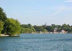
Jamaica Pond
.jpg)
Jamaica Pond is a kettle pond, part of the Emerald Necklace of parks in Boston designed by Frederick Law Olmsted. The pond and park are in the Jamaica Plain neighborhood of Boston, close to the border of Brookline. It is the source of the Muddy River, which drains into the lower Charles River.USGS 2005
The pond has an area of about 68 acres (28 ha), and is 53 feet (16 m) deep at its center (MassWildlife map), making it the largest body of fresh water in Boston, and the largest natural freshwater body in the lower Charles River watershed. It is ringed by a 1.5 mile walking path, and is an extremely popular destination for Bostonians for walking, fishing, rowing, and sailing. Around Halloween each year, the pond serves as the site for The Lantern Parade. Participants dress in their Halloween costumes and walk around the pond.
The pond once served as a reservoir for the City of Boston and the Town of West Roxbury, and it supplied ice in the winter to Boston and beyond.
According to the USGS, the name Jamaica derives from an Indian name meaning "abundance of beavers".[1]
History
The Jamaica Plain Ice Company employed 350 men in 1874, and harvested as much 5,000 tons of ice a day from Jamaica Pond.[2]
The pond was once the site of a popular annual winter skating carnival. In 1929, this carnival was cancelled by Mayor Curley when cracks appeared on the ice, and 50,000 skaters had to be evacuated.[3] In recent years, ice skating is no longer permitted on the pond.
Overlooking Jamaica Pond until its 2007 demolition was Pinebank Mansion, the summer home of Edward Newton Perkins.
References
- Water resources and the urban environment, lower Charles River Watershed; ISBN 1-4289-8365-1
- Weiskel, Peter K.; Barlow, Lora K.; Smieszek, Tomas W. (2005). "Water Resources and the Urban Environment, Lower Charles River Watershed, Massachusetts, 1630–2005" (PDF). http://www.usgs.gov/. Reston, Virginia: U.S. Geological Survey. Retrieved February 4, 2014. External link in
|website=(help)
- ↑ U.S. Geological Survey Geographic Names Information System: Jamaica Pond
- ↑ Rosenberg, Charlie (Nov 2007). "Jamaica Plain Historical Society 'Locales' Editor, Harvesting Ice on Jamaica Pond". Jamaica Plain Historical Society. Archived from the original on October 22, 2010. Retrieved June 4, 2010.
- ↑ Remember Jamaica Plain? Fifty Thousand on Jamaica Pond Ice? Wow!
External links
| Wikimedia Commons has media related to Jamaica Pond. |
- MassWildlife map and information
- Boston Parks & Recreation Department
- Emerald Necklace Conservancy
- Friends of Jamaica Pond
- The Jamaica Pond Project
- Jamaica Pond Ice Houses and Trade
- Boating on Jamaica Pond by Courageous Sailing
- Jamaica Pond Lantern Parade by Spontaneous Celebrations
Coordinates: 42°19′0″N 71°7′13″W / 42.31667°N 71.12028°W
 | ||