East Harbor
East Harbor is the name of a tidal estuary in Truro, Massachusetts that was formerly a harbor until it was cut off from Cape Cod Bay. It is now within Cape Cod National Seashore.
After an oxygen depletion and fish kill in 2001, the town and the National Park Service began to explore options to restore the estuary. Over time, the blockage of tides has caused numerous ecological problems. The lack of tidal flushing had deprived the system of salty, nutrient-poor, oxygen-rich Cape Cod Bay water and it became a stagnant freshwater pond. These conditions resulted in midge outbreaks, fish kills, and a proliferation of exotic species. In 2002, the National Park Service received permission to open up the tidal locks between the two bodies of water to improve the quality of water in the harbor. Over time, the blockage of tides has caused numerous ecological problems. The lack of tidal flushing deprived the system of salty, nutrient-poor, oxygen-rich Cape Cod Bay water and it became a stagnant freshwater pond. These conditions resulted in midge outbreaks, fish kills, and a proliferation of exotic species. [3]
In June 2008, it was renamed back to its original name from Pilgrim Lake, a name which it held for over one hundred years.[4]
The 720-acre East Harbor system, includes Moon Meadow, Salt Meadow and the East Harbor lagoon. From Route 6, while driving along the edge of the lagoon, one can see stunning white dunes on the far side.
References
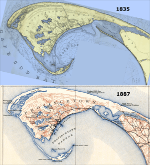
- ↑ A map of the extremity Of Cape Cod including the Townships of Provincetown & Truro: with a chart of their sea coast and of Cape Cod Harbour, State of Massachusetts (Map). 1 : 10,560. Cartography by U.S. Topographical Engineers, under direction of Maj. J.D. Graham; Reduced from orig. by Washington Hood. Bureau of U.S. Topographical Engineers. 1836. Retrieved 2 June 2012.
- ↑ Massachusetts: Provincetown Sheet (PDF) (Map). 1 : 62,500. Cartography by Henry Gannett (Chief Geographer) and Marcus Baker (Geographer-in-Charge). United States Geological Survey. July 1889 [Surveyed 1887]. Retrieved 23 May 2012.
- ↑ "East Harbor Tidal Restoration Project". National Park Service. April 28, 2015. Retrieved 21 June 2018.
- ↑ "East Harbor gets its name back". Wicked Local Provincetown. 20 June 2008. Retrieved 13 March 2014.
Coordinates: 42°3′32.18″N 70°7′46.33″W / 42.0589389°N 70.1295361°W