Jacks Mountain Covered Bridge
|
Jacks Mountain Covered Bridge | |
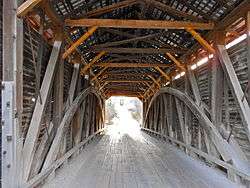 Interior | |
  | |
| Location | Southwest of Fairfield on Legislative Route 01053, near Iron Springs, Hamiltonban Township, Pennsylvania |
|---|---|
| Coordinates | 39°46′1″N 77°23′13″W / 39.76694°N 77.38694°WCoordinates: 39°46′1″N 77°23′13″W / 39.76694°N 77.38694°W |
| Area | 0.1 acres (0.040 ha) |
| Architect | Smith, Joseph |
| Architectural style | Other, Burr truss |
| MPS | Covered Bridges of Adams, Cumberland, and Perry Counties TR |
| NRHP reference # | 80003397[1] |
| Added to NRHP | August 25, 1980 |
The Jacks Mountain Covered Bridge (officially known as the G. Donald McLaughlin Memorial Covered Bridge) is a historic covered bridge in Hamiltonban Township, Adams County, Pennsylvania. It was built in 1890, and is a 75-foot-long (23 m), Burr truss bridge with narrow horizontal siding and a tin covered gable roof. The bridge crosses Tom's Creek. It is one of 17 covered bridges in Adams, Cumberland, and Perry Counties.[2]
It was added to the National Register of Historic Places in 1980.[1]
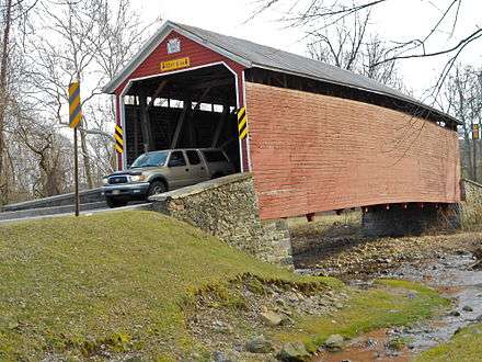
View from the north
References
- 1 2 National Park Service (July 9, 2010). "National Register Information System". National Register of Historic Places. National Park Service.
- ↑ "National Historic Landmarks & National Register of Historic Places in Pennsylvania" (Searchable database). CRGIS: Cultural Resources Geographic Information System. Note: This includes Susan M. Zacher (n.d.). "National Register of Historic Places Inventory Nomination Form: Covered Bridges of Adams, Cumberland, and Perry Counties Thematic Resources (Jacks Mountain Covered Bridge)" (PDF). Retrieved December 8, 2011.
| Topics |   | |
|---|---|---|
| Lists by county |
| |
| Lists by city | ||
| Other lists | ||
| ||
This article is issued from
Wikipedia.
The text is licensed under Creative Commons - Attribution - Sharealike.
Additional terms may apply for the media files.