Jüterbog
| Jüterbog | ||
|---|---|---|
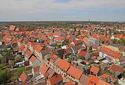 View of the village from St. Nicholas church | ||
| ||
 Jüterbog Location of Jüterbog within Teltow-Fläming district 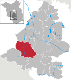 | ||
| Coordinates: 51°59′36″N 13°04′22″E / 51.99333°N 13.07278°ECoordinates: 51°59′36″N 13°04′22″E / 51.99333°N 13.07278°E | ||
| Country | Germany | |
| State | Brandenburg | |
| District | Teltow-Fläming | |
| Government | ||
| • Mayor | Arne Raue | |
| Area | ||
| • Total | 175.68 km2 (67.83 sq mi) | |
| Elevation | 71 m (233 ft) | |
| Population (2017-12-31)[1] | ||
| • Total | 12,393 | |
| • Density | 71/km2 (180/sq mi) | |
| Time zone | CET/CEST (UTC+1/+2) | |
| Postal codes | 14913 | |
| Dialling codes | 03372 | |
| Vehicle registration | TF (auslaufend JB) | |
| Website | www.jueterbog.eu | |

Jüterbog is a historic village in north-eastern Germany, in the Teltow-Fläming district of Brandenburg. It is on the Nuthe river at the northern slope of the Fläming hill range, about 65 km (40 mi) southwest of Berlin.
History
The Slavic settlement of Jutriboc in the Saxon Eastern March was first mentioned in 1007 by Thietmar of Merseburg, chronicler of Archbishop Tagino of Magdeburg. It nevertheless was not incorporated into the Magdeburg diocese until in 1157 Archbishop Wichmann von Seeburg in the train of Albert the Bear established a burgward here. In 1170 Wichmann also founded neighbouring Zinna Abbey and granted Jüterbog town privileges in 1174. The area remained a Magdeburg exclave between the Duchy of Saxe-Wittenberg and the Margraviate of Brandenburg throughout the Middle Ages.
In March 1611 a treaty was signed in Jüterbog between Brandenburg and the Electorate of Saxony in a failed attempt to end the War of the Jülich succession. In November 1644, during the Thirty Years' War, Swedish troops defeated an Imperial army nearby. While the Magdeburg Archbishopric was promised to Brandenburg-Prussia by the 1648 Peace of Westphalia, the town of Jüterbog passed to Saxony.
The Battle of Dennewitz occurred two miles (3 km) southwest of Jüterbog on 6 September 1813 during the Napoleonic Wars. The Final Act of the 1815 Congress of Vienna finally adjudicated the town to the Kingdom of Prussia, it was subsequently administered within the Province of Brandenburg and became a garrison town of the Prussian Army. In 1871 it became part of the German Empire during the unification of Germany.
Under Nazi rule, Jüterbog's army base was greatly expanded and three surrounding villages were razed to make space for training areas. During the partition of Germany from 1945 to 1990, Jüterbog was part of East Germany and remained an important garrison town, now of the Red Army. Up to 40,000 Soviet soldiers were garrisoned in imposing Nazi-era barracks and in new buildings in the countryside. The huge garrison, about four times larger than the civilian population, strongly disrupted civilian life and the town was occasionally shelled as a result of indiscriminate Soviet artillery training. After the Red Army left reunified Germany in 1990, the 20,000 hectares (77 sq mi) military area was and remains closed to the public because of security and environmental hazards.[2]
Demography
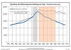 Development of Population since 1875 within the Current Boundaries (Blue Line: Population; Dotted Line: Comparison to Population Development of Brandenburg state; Grey Background: Time of Nazi rule; Red Background: Time of Communist rule)
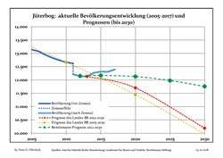 Recent Population Development and Projections (Population Development before Census 2011 (blue line); Recent Population Development according to the Census in Germany in 2011 (blue bordered line); Projection by the Brandenburg state for 2005-2030 (yellow line); Projection by the Brandenburg state for 2014-2030 (red line); Projection by the Bertelsmann Foundation for 2012-2030 (green line)
| Jüterbog: Population development within the current boundaries (2017)[3] | ||||||||||||||||||||||||||||||||||||||||||||||||||||||||||||||||||||||||||||||||||||||||||||||||||||||||||||||||||||||||||||||||||||||
|---|---|---|---|---|---|---|---|---|---|---|---|---|---|---|---|---|---|---|---|---|---|---|---|---|---|---|---|---|---|---|---|---|---|---|---|---|---|---|---|---|---|---|---|---|---|---|---|---|---|---|---|---|---|---|---|---|---|---|---|---|---|---|---|---|---|---|---|---|---|---|---|---|---|---|---|---|---|---|---|---|---|---|---|---|---|---|---|---|---|---|---|---|---|---|---|---|---|---|---|---|---|---|---|---|---|---|---|---|---|---|---|---|---|---|---|---|---|---|---|---|---|---|---|---|---|---|---|---|---|---|---|---|---|---|
|
|
| ||||||||||||||||||||||||||||||||||||||||||||||||||||||||||||||||||||||||||||||||||||||||||||||||||||||||||||||||||||||||||||||||||||
Sights
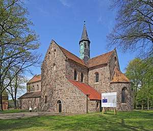
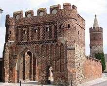
The town is surrounded by a medieval wall including three gateways and barbicans. It encompasses two Protestant churches, of which Gothic St Nicholas' (14th century) is remarkable for its three fine aisles and features a preserved coffer of Johann Tetzel.
There are also a Roman Catholic church, the old town-hall with a statue of Saint Maurice from the 16th century and a modern school. Jüterbog carries on weaving and spinning both of flax and wool, and trades in the produce of those manufactures and in cattle. Vines are cultivated in the neighborhood.
Zinna Abbey, the Cistercian monastery founded in 1170, is about 3 km (1.9 mi) north of the town.
Politics
Seats in the municipal assembly (Stadtverordnetenversammlung) as of 2008 elections:
- Social Democratic Party of Germany (SPD): 6
- The Left: 6
- Christian Democratic Union (CDU): 3
- Free Democratic Party (FDP): 3
- Bauernverband (farmers' union): 3
- German People's Union (DVU): 1
Transport
In 1841 Jüterbog station received access to the Berlin-Anhalt Railway line. Today the station is located at the junction of the railway line from Berlin to Wittenberg and a branch-off to Falkenberg/Elster, all served by Regional-Express trains of the Deutsche Bahn company. A third railway connection to Beelitz and Berlin-Wannsee is provided by the private Veolia Verkehr company.
Furthermore, Jüterbog can be reached via Bundesstraße 101 from Berlin and the Berliner Ring motorway as well as via Bundesstraße 102 from the Bundesautobahn 9 at Niemegk junction.
Three Airfields are in the vicinity of Jüterbog: the Jüterbog Airfield few km to the west, the Oehna Airfield 10 km to the south, and the Reinsdorf Airfield 15 km south-east of Jüterbog.
Notable people
- Jacob of Juterbogk (1381-1465), theologian
- Johann Deutschmann (1625–1706), theologian
- Johann Friedrich von Brandt (1802–1879), naturalist
- Hans Peter Hallwachs (born 1938), actor
- Friedrich Gottlob Hayne (1763-1832), botanist
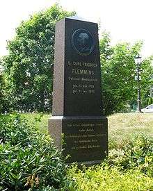
- Carl Friedrich Flemming (1799-1880), psychiatrist
- Max Kämper (1879-1916), mining engineer
- Wilhelm Kempff (1895-1991), pianist and composer
- Ulrich Wegener (born 1929), police officer, first commander of the GSG 9
International relations
Jüterbog is twinned with:
References
- ↑ "Bevölkerung im Land Brandenburg nach amtsfreien Gemeinden, Ämtern und Gemeinden 31. Dezember 2017 (Fortgeschriebene amtliche Einwohnerzahlen auf Grundlage des Zensus 2011)". Amt für Statistik Berlin-Brandenburg (in German). 2018.
- ↑ Hauser, Beat (27 September 2010). "Nachbarschaft mit Sprengkraft". Spiegel Online. Retrieved 9 October 2010.
- ↑ Detailed data sources are to be found in the Wikimedia Commons.Population Projection Brandenburg at Wikimedia Commons

External links
![]()
Towns and municipalities in Teltow-Fläming | ||
|---|---|---|
| Authority control |
|---|