Baruth/Mark
| Baruth/Mark | ||
|---|---|---|
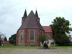 Saint Sebastian parish church | ||
| ||
 Baruth/Mark Location of Baruth/Mark within Teltow-Fläming district 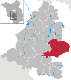 | ||
| Coordinates: 52°03′N 13°30′E / 52.050°N 13.500°ECoordinates: 52°03′N 13°30′E / 52.050°N 13.500°E | ||
| Country | Germany | |
| State | Brandenburg | |
| District | Teltow-Fläming | |
| Government | ||
| • Mayor | Peter Ilk (LOB) | |
| Area | ||
| • Total | 233.62 km2 (90.20 sq mi) | |
| Elevation | 51-145 m (−425 ft) | |
| Population (2017-12-31)[1] | ||
| • Total | 4,137 | |
| • Density | 18/km2 (46/sq mi) | |
| Time zone | CET/CEST (UTC+1/+2) | |
| Postal codes | 15837 | |
| Dialling codes | 033704 | |
| Vehicle registration | TF | |
| Website | www.stadt-baruth-mark.de | |

Baruth/Mark is a town in the Teltow-Fläming district of Brandenburg, Germany. It is situated 24 km east of Luckenwalde, and 53 km south of Berlin.
Geography
Baruth/Mark is structured in the following parts of town,[2] which are all villages and mainly former municipalities:
- Baruth/Mark
- Klein Ziescht
- Dornswalde
- Groß Ziescht
- Kemlitz
- Horstwalde
- Klasdorf
- Glashütte
- Ließen
- Merzdorf
- Mückendorf
- Paplitz
- Petkus
- Charlottenfelde
- Radeland
- Schöbendorf
Demography
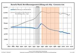 Development of Population since 1875 within the Current Boundaries (Blue Line: Population; Dotted Line: Comparison to Population Development of Brandenburg state; Grey Background: Time of Nazi rule; Red Background: Time of Communist rule)
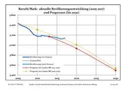 Recent Population Development and Projections (Population Development before Census 2011 (blue line); Recent Population Development according to the Census in Germany in 2011 (blue bordered line); Projection by the Brandenburg state for 2005-2030 (yellow line); Projection by the Brandenburg state for 2014-2030 (red line)
| Baruth/Mark: Population development within the current boundaries (2017)[3] | ||||||||||||||||||||||||||||||||||||||||||||||||||||||||||||||||||||||||||||||||||||||||||||||||||||||||||||||||||||||||||||||||||||||
|---|---|---|---|---|---|---|---|---|---|---|---|---|---|---|---|---|---|---|---|---|---|---|---|---|---|---|---|---|---|---|---|---|---|---|---|---|---|---|---|---|---|---|---|---|---|---|---|---|---|---|---|---|---|---|---|---|---|---|---|---|---|---|---|---|---|---|---|---|---|---|---|---|---|---|---|---|---|---|---|---|---|---|---|---|---|---|---|---|---|---|---|---|---|---|---|---|---|---|---|---|---|---|---|---|---|---|---|---|---|---|---|---|---|---|---|---|---|---|---|---|---|---|---|---|---|---|---|---|---|---|---|---|---|---|
|
|
| ||||||||||||||||||||||||||||||||||||||||||||||||||||||||||||||||||||||||||||||||||||||||||||||||||||||||||||||||||||||||||||||||||||
Photogallery
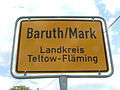 Street sign on entry to Baruth/Mark
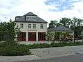 Firehouse
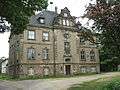 Castle Baruth
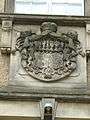 Fascia detail, Castle Baruth
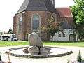 Cathedral
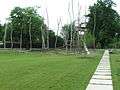 Municipal Playground
Sons and daughters of the town
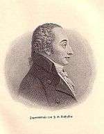
Johann Gottlob Nathusius
- Christian Kunth (1757-1829), educator, educator of Alexander and Wilhelm von Humboldt
- Johann Gottlob Nathusius (1760-1835), entrepreneur
- Johann Georg Lehmann (1765-1811), surveyor and cartographer
References
- ↑ "Bevölkerung im Land Brandenburg nach amtsfreien Gemeinden, Ämtern und Gemeinden 31. Dezember 2017 (Fortgeschriebene amtliche Einwohnerzahlen auf Grundlage des Zensus 2011)". Amt für Statistik Berlin-Brandenburg (in German). 2018.
- ↑ Main constitution of the town of Baruth/Mark PDF (in German)
- ↑ Detailed data sources are to be found in the Wikimedia Commons.Population Projection Brandenburg at Wikimedia Commons
Towns and municipalities in Teltow-Fläming | ||
|---|---|---|
| Authority control |
|---|
This article is issued from
Wikipedia.
The text is licensed under Creative Commons - Attribution - Sharealike.
Additional terms may apply for the media files.