Luckenwalde
| Luckenwalde | ||
|---|---|---|
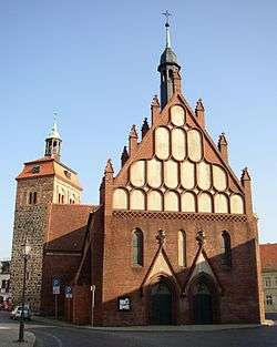 Market tower and St. John's Church | ||
| ||
 Luckenwalde Location of Luckenwalde within Teltow-Fläming district 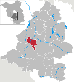 | ||
| Coordinates: 52°05′N 13°10′E / 52.083°N 13.167°ECoordinates: 52°05′N 13°10′E / 52.083°N 13.167°E | ||
| Country | Germany | |
| State | Brandenburg | |
| District | Teltow-Fläming | |
| Government | ||
| • Mayor | Elisabeth Herzog-von der Heide (SPD) | |
| Area | ||
| • Total | 46.75 km2 (18.05 sq mi) | |
| Elevation | 48 m (157 ft) | |
| Population (2017-12-31)[1] | ||
| • Total | 20,674 | |
| • Density | 440/km2 (1,100/sq mi) | |
| Time zone | CET/CEST (UTC+1/+2) | |
| Postal codes | 14943 | |
| Dialling codes | 03371 | |
| Vehicle registration | TF | |
| Website | www.luckenwalde.de | |

Luckenwalde (German pronunciation: [lʊkənˈvaldə]; Upper and Lower Sorbian: Łukowc) is the capital of the Teltow-Fläming district in the German state of Brandenburg. It is situated on the Nuthe river north of the Fläming Heath, at the eastern rim of the Nuthe-Nieplitz Nature Park, about 50 km (31 mi) south of Berlin. The town area includes the villages of Frankenfelde and Kolzenburg.
Overview
The former Slavic settlement of Lugkin was conquered by Margrave Conrad Wettin of Meissen in the course of the 1147 Wendish Crusade. Lukenwalde Castle was first mentioned in a 1216 deed as a burgward of the Bishopric of Brandenburg, it was acquired by Zinna Abbey in 1285. Together with Zinna it remained under the rule of the Archbishopric of Magdeburg and its successor, the Prussian Duchy of Magdeburg until it was attached to the Margraviate of Brandenburg in 1773.
Originating in the 17th century, Luckenwalde's cloth and wool factories did not spring up till the reign of King Frederick II of Prussia and soon were among the most extensive in Germany. Other traditional industries were cotton printing and a dye works, brewing, and the making of metal and bronze goods. In 1808 Luckenwalde officially received town privileges.
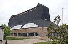
By the turn of the 20th Century Luckenwalde became renowned as a key manufacturer of hats. In 1921 the two biggest hat ateliers, Herrmann and Steinberg, merged and set up their factory on an industrial estate in Luckenwalde. The factory was designed by German architect Erich Mendelsohn in 1923, the factory is considered a milestone of Expressionist architecture. The hat factory fell into disrepair during and after the war period and was restored in 2001, but as of 2013 the building remains empty.[2]
During World War II, there was a Stalag for prisoners of war (Stalag IIIa). There was also a work camp for civilians. The Nazis forced people to work for their war effort or else the families of people who worked there would perish. Lack of food and hard work killed thousands. Among them were Poles, Italians, French and many more. There were several places in the town and surrounding areas where they worked. Luckenwalde was taken by the Red Army on 22 April 1945.
Demography
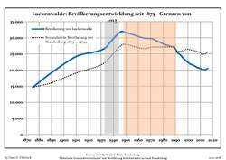 Development of Population since 1875 within the Current Boundaries (Blue Line: Population; Dotted Line: Comparison to Population Development of Brandenburg state; Grey Background: Time of Nazi rule; Red Background: Time of Communist rule)
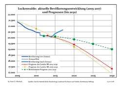 Recent Population Development and Projections (Population Development before Census 2011 (blue line); Recent Population Development according to the Census in Germany in 2011 (blue bordered line); Projection by the Brandenburg state for 2005-2030 (yellow line); Projection by the Brandenburg state for 2014-2030 (red line); Projection by the Bertelsmann Foundation for 2012-2030 (green line)
| Luckenwalde: Population development within the current boundaries (2017)[3] | ||||||||||||||||||||||||||||||||||||||||||||||||||||||||||||||||||||||||||||||||||||||||||||||||||||||||||||||||||||||||||||||||||||||
|---|---|---|---|---|---|---|---|---|---|---|---|---|---|---|---|---|---|---|---|---|---|---|---|---|---|---|---|---|---|---|---|---|---|---|---|---|---|---|---|---|---|---|---|---|---|---|---|---|---|---|---|---|---|---|---|---|---|---|---|---|---|---|---|---|---|---|---|---|---|---|---|---|---|---|---|---|---|---|---|---|---|---|---|---|---|---|---|---|---|---|---|---|---|---|---|---|---|---|---|---|---|---|---|---|---|---|---|---|---|---|---|---|---|---|---|---|---|---|---|---|---|---|---|---|---|---|---|---|---|---|---|---|---|---|
|
|
| ||||||||||||||||||||||||||||||||||||||||||||||||||||||||||||||||||||||||||||||||||||||||||||||||||||||||||||||||||||||||||||||||||||
Politics
Seats in the municipal assembly (Stadtverordnetenversammlung) as of 2014 elections:[4]
- The Left: 10
- Social Democratic Party of Germany (SPD): 9
- Christian Democratic Union (CDU): 6
- Bauernverband (BV): 1
- Free Democratic Party (FDP): 1
- National Democratic Party of Germany (NPD): 1
Transport
Luckenwalde station is located on the Berlin–Halle railway.
Born in Luckenwalde
- Hans Freudenthal, (1905-1990), mathematician
- Bernhard Kadenbach, (born 1933), biochemist
- Katherina Reiche, (born 1973), politician (CDU),
- Ilka Bessin, (born 1971), comedian (Cindy aus Marzahn),
- Rudi Dutschke (1940–1979), spokesman of the German 1968 student movement, was raised in Luckenwalde
International relations
Luckenwalde is twinned with:


References
- ↑ "Bevölkerung im Land Brandenburg nach amtsfreien Gemeinden, Ämtern und Gemeinden 31. Dezember 2017 (Fortgeschriebene amtliche Einwohnerzahlen auf Grundlage des Zensus 2011)". Amt für Statistik Berlin-Brandenburg (in German). 2018.
- ↑ Hat Factory on Architectuul
- ↑ Detailed data sources are to be found in the Wikimedia Commons.Population Projection Brandenburg at Wikimedia Commons
- ↑ "Municipal election 25.05.2014 - STVV Luckenwalde". Stadt Luckenwalde. Retrieved 19 October 2014.
![]()
External links
![]()
Notgeld (emergency banknotes) depicting the industries Luckenwalde was known for in the early 20th century. http://webgerman.com/Notgeld/Directory/L/Luckenwalde.htm
Towns and municipalities in Teltow-Fläming | ||
|---|---|---|
| Authority control |
|---|