Ishpeming, Michigan
| Ishpeming, Michigan | |
|---|---|
| City | |
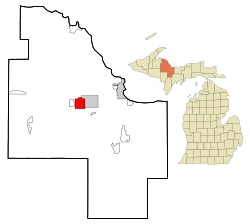 Location of Ishpeming, Michigan | |
| Coordinates: 46°29′33″N 87°40′3″W / 46.49250°N 87.66750°W | |
| Country | United States |
| State | Michigan |
| County | Marquette |
| Government | |
| • Type | Council-Mayor |
| • Mayor | Joseph Juidici |
| Area[1] | |
| • Total | 9.35 sq mi (24.22 km2) |
| • Land | 8.74 sq mi (22.64 km2) |
| • Water | 0.61 sq mi (1.58 km2) |
| Elevation | 1,407 ft (429 m) |
| Population (2010)[2] | |
| • Total | 6,470 |
| • Estimate (2016)[3] | 6,471 |
| • Density | 690/sq mi (270/km2) |
| Time zone | UTC-5 (Eastern (EST)) |
| • Summer (DST) | UTC-4 (EDT) |
| ZIP codes | 49849, 49865 |
| Area code(s) | 906 |
| FIPS code | 26-41220[4] |
| GNIS feature ID | 0629103[5] |
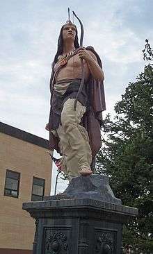
Ishpeming /ˈɪʃpəmɪŋ/ is a city in Marquette County in the Upper Peninsula of the U.S. state of Michigan. The population was 6,470 at the 2010 census. This is down from a higher population in the 1950s and 1960s when the economically supportive iron ore mines employed more workers. A statue of a Native American figure, erected in 1884 in the small town square, is referred to as "Old Ish".
Ishpeming Township is located to the northwest of the city but is administratively autonomous. Ishpeming is considered the birthplace of organized skiing in the United States and is the home to the National Ski Hall of Fame. The city was also prominently featured in the 2010 documentary Catfish.
The name Ishpeming comes from the Ojibwe word ishpiming, meaning "above", "in the air" or "on high".[6]
Geography
According to the United States Census Bureau, the city has a total area of 9.35 square miles (24.22 km2), of which 8.74 square miles (22.64 km2) is land and 0.61 square miles (1.58 km2) is water.[1] Ishpeming's elevation is 1,436 feet (438 m) above mean sea level, which is over 800 feet (240 m) higher than that of nearby Lake Superior. The highlands of Ishpeming and the surrounding area, including the city of Negaunee to its east, receive an unusually high yearly average of lake effect snow.
Demographics
| Historical population | |||
|---|---|---|---|
| Census | Pop. | %± | |
| 1880 | 6,039 | — | |
| 1890 | 11,197 | 85.4% | |
| 1900 | 13,255 | 18.4% | |
| 1910 | 12,448 | −6.1% | |
| 1920 | 10,500 | −15.6% | |
| 1930 | 9,238 | −12.0% | |
| 1940 | 9,491 | 2.7% | |
| 1950 | 8,962 | −5.6% | |
| 1960 | 8,857 | −1.2% | |
| 1970 | 8,245 | −6.9% | |
| 1980 | 7,538 | −8.6% | |
| 1990 | 7,200 | −4.5% | |
| 2000 | 6,686 | −7.1% | |
| 2010 | 6,470 | −3.2% | |
| Est. 2016 | 6,471 | [3] | 0.0% |
| U.S. Decennial Census[7] | |||
2010 census
As of the census[2] of 2010, there were 6,470 people, 2,824 households, and 1,664 families residing in the city. The population density was 740.3 inhabitants per square mile (285.8/km2). There were 3,149 housing units at an average density of 360.3 per square mile (139.1/km2). The racial makeup of the city was 96.0% White, 0.2% African American, 1.1% Native American, 0.3% Asian, 0.1% from other races, and 2.2% from two or more races. Hispanic or Latino of any race were 1.0% of the population.
There were 2,824 households of which 28.3% had children under the age of 18 living with them, 42.0% were married couples living together, 12.2% had a female householder with no husband present, 4.7% had a male householder with no wife present, and 41.1% were non-families. 33.9% of all households were made up of individuals and 13.4% had someone living alone who was 65 years of age or older. The average household size was 2.23 and the average family size was 2.85.
The median age in the city was 40.3 years. 21.7% of residents were under the age of 18; 8.9% were between the ages of 18 and 24; 25.1% were from 25 to 44; 27.3% were from 45 to 64; and 17% were 65 years of age or older. The gender makeup of the city was 48.2% male and 51.8% female.
2000 census
As of the census[4] of 2000, there were 6,686 people, 2,915 households, and 1,757 families residing in the city. The population density was 769.8 per square mile (297.1/km²). There were 3,210 housing units at an average density of 369.6 per square mile (142.6/km²). The racial makeup of the city was 97.29% White, 0.06% Black, 1.20% Native American, 0.19% Asian, 0.27% from other races, and 0.99% from two or more races. Hispanic or |Latino of any race were 0.81% of the population. 25.5% were of Finnish, 14.4% Italian, 14.1% English, 12.4% French, 7.3% German, 5.7% Swedish and 5.1% Irish ancestry according to Census 2000. 95.8% spoke English and 1.9% Finnish as their first language.
There were 2,915 households out of which 27.7% had children under the age of 18 living with them, 43.8% were married couples living together, 12.3% had a female householder with no husband present, and 39.7% were non-families. 34.0% of all households were made up of individuals and 15.2% had someone living alone who was 65 years of age or older. The average household size was 2.25 and the average family size was 2.89.
In the city, the population was spread out with 23.2% under the age of 18, 9.2% from 18 to 24, 26.9% from 25 to 44, 21.8% from 45 to 64, and 19.0% who were 65 years of age or older. The median age was 39 years. For every 100 females, there were 89.6 males. For every 100 females age 18 and over, there were 87.1 males.
The median income for a household in the city was $31,347, and the median income for a family was $38,924. Males had a median income of $36,310 versus $21,104 for females. The per capita income for the city was $16,946. About 8.0% of families and 11.1% of the population were below the poverty line, including 15.5% of those under age 18 and 6.8% of those age 65 or over.
Transportation
Highways
Airport
- Ishpeming, which is part of the greater Marquette area, is served by Sawyer International Airport with flights to Chicago, Detroit, and Minneapolis.
Bus
Rail
- Until 1969, the Chicago & Northwestern Railroad ran its Peninsula 400 to Ishpeming from Chicago. In its last days, the train consisted of one engine and one bi-level passenger car.
Historical events
- The movie Anatomy of a Murder was filmed in Ishpeming and surrounding areas in 1959, based on the novel by Ishpeming native John D. Voelker under the pen name Robert Traver. Extensive 50th anniversary celebrations were held in 2009.[9]
- The Green Bay Packers played their first ever road game in Ishpeming on October 19, 1919. The Packers won 33–0.[10]
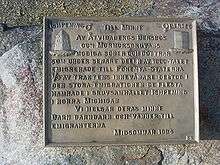
- At the end of the 19th century almost one third of the population of Åtvidaberg Municipality in Sweden emigrated to Ishpeming, as copper mines in the Åtvidaberg area closed down.[11] In 1994 this was commemorated by a plaquette at the Mormorsgruvan mine of Åtvidaberg.
- The National Ski Association, the forerunner of the present-day United States Ski and Snowboard Association, was founded in Ishpeming on February 21, 1905. The founder and president was local banker and skier, Carl Tellefsen.[12]
Climate
This climatic region is typified by large seasonal temperature differences, with warm to hot (and often humid) summers and cold (sometimes severely cold) winters. According to the Köppen Climate Classification system, Ishpeming has a humid continental climate, abbreviated "Dfb" on climate maps.[13]
Notable people
- Chuck Fairbanks, NCAA Division I and NFL Head Football Coach. IHS Head Coach, 1957, 1958
- Tom Izzo, head coach, Michigan State University basketball. Head coach, 1977 Ishpeming High School.
- Clarence "Kelly" Johnson, preeminent aviation engineer, designer of SR-71 and leader at the "skunk works."
- Glenn T. Seaborg, Nobel prize winning chemist.
- John D. Voelker, author under the pen name Robert Traver, and Michigan state Supreme Court Justice.
- Leonard C. Ward, United States Army Brigadier General who served as Chief of the Army Division at the National Guard Bureau and Commander of the 46th Infantry Division.
- Da Yoopers, band.
- Will H. Bradley, one of the most influential illustrators and designers of the Art Nouveau movement, was an apprentice in Ishpeming at the Iron Agitator, later known as the Iron Ore, from age 11 to 17, when he moved to Chicago.[14]
Points of interest
- Al Quaal Recreation Center
- Cliffs Shaft Mine Museum, commemorating the history of mining on the Marquette Iron Range
- Jasper Knob, a bald topped hill composed entirely of jaspilite; a geological formation of the Marquette Iron Range.[15]
- The Mather Inn
- National Ski Hall of Fame
- Old Ish Statue
- Suicide Hill Ski Jump
- W.C. Peterson Auditorium
- Ishpeming Carnegie Public Library
- Lake Bancroft
Education
Ishpeming Public School District No. 1 consisting of:
- Ishpeming High School: The school nickname is the Hematites, after the iron ore mined in the city.
- Ishpeming Middle School (Sharing the High School)
- Birchview Elementary School
In the adjacent Ishpeming Township, the N.I.C.E. Community Schools consists of
- Westwood High School: Mascot – Patriots
- Aspen Ridge Middle School: Mascot – Patriots
- Aspen Ridge Elementary School: Mascot – Patriots
Places of worship
- Bethany Lutheran Church
- Bethel Lutheran Church
- Bible Baptist Church
- Cross Bridge Church
- Christ The King Lutheran Church (Christking-ish.org)
- Good News Assembly of God
- Grace Episcopal Church
- Hope Free Evangelical Lutheran Church
- Old Fashioned Baptist Church
- St. John the Evangelist Catholic Church
- St. Joseph Catholic Church
- Trinity Lutheran Church
- United Evangelical Covenant Church
- Wesley United Methodist Church
- The Salvation Army
- Temple Beth Sholom (Reform synagogue)
Festivals and events
- Noquemanon Ski Marathon, January
- Ski jumping competition at Suicide Hill[16]
- National Ski Hall of Fame membership induction ceremonies
- St. Rocco and St. Anthony Society of Ishpeming annual "Italian Fest", July
See also
- Iron Ore, the city's weekly newspaper from 1886 to 1951
- Peninsula 400, an express passenger train from Chicago that terminated in Ishpeming until 1969
References
- 1 2 "US Gazetteer files 2010". United States Census Bureau. Archived from the original on 2012-01-24. Retrieved 2012-11-25.
- 1 2 "American FactFinder". United States Census Bureau. Retrieved 2012-11-25.
- 1 2 "Population and Housing Unit Estimates". Retrieved June 9, 2017.
- 1 2 "American FactFinder". United States Census Bureau. Archived from the original on 2013-09-11. Retrieved 2008-01-31.
- ↑ "US Board on Geographic Names". United States Geological Survey. 2007-10-25. Retrieved 2008-01-31.
- ↑ http://www.translateojibwe.com/en/dictionary-ojibwe-english/ishpiming
- ↑ "Census of Population and Housing". Census.gov. Archived from the original on May 12, 2015. Retrieved June 4, 2015.
- ↑ "HANCOCK-MARQUETTE-GREEN BAY-MILWAUKEE" (PDF). Indian Trails. January 12, 2012. Archived from the original (PDF) on February 22, 2014. Retrieved 2013-02-27.
- ↑ Monaghan, John (January 20, 2009). "The movie that put Ishpeming on the map: UP plans events this summer to mark 50th anniversary of 'Anatomy of a Murder'". Detroit Free Press. .
- ↑ "Twin City Meets Defeat: Ishpeming–Negaunee Eleven Lost by 33 to 0 Score to Green Bay". Iron Ore. Ishpeming. October 1919. Archived from the original on August 28, 2008. Retrieved March 10, 2012.
- ↑ Staff (2008). "Swedish Migration and Settlement in Marquette County". Recorded in Stone: Voices on the Marquette Iron Range. Central Upper Peninsula and Northern Michigan University Archives. Archived from the original on March 2, 2012. Retrieved March 10, 2012.
- ↑ Staff (2007). "USSA History". U.S. Ski and Snowboard Association. Archived from the original on April 12, 2009. Retrieved March 10, 2012.
- ↑ Climate Summary for Ishpeming, Michigan
- ↑ Meggs, Philip B.; Purvis, Alston W. (2012), Meggs' History of Graphic Design (5th ed.), Hoboken NJ: John Wiley & Sons Inc
- ↑ St. John, James. "Jasper Knob". Ohio State University – Newark.
- ↑ Wood, Vivian (1997). "Ski Jumping Competion [sic] at Suicide Hill, Ishpeming, Michigan". Exploring the North. Self-published. Retrieved March 10, 2012.
- Boyum, Burt; LaFreniere, Jamie (2003). The Ishpeming Ski Club: Over a Century of Skiing. US National Ski and Hall of Fame Museum.

External links
Municipalities and communities of Marquette County, Michigan, United States | ||
|---|---|---|
| Cities | 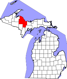 | |
| Charter townships | ||
| General law townships | ||
| CDPs | ||
| Other unincorporated communities | ||
| Indian reservation | ||
| Footnotes | ‡This populated place also has portions in an adjacent county or counties | |
Coordinates: 46°29′19″N 87°40′03″W / 46.48861°N 87.66750°W