Iron River (CDP), Wisconsin
| Iron River, Wisconsin | |
|---|---|
| Census-designated place | |
 Iron River | |
| Coordinates: 46°33′52″N 91°24′30″W / 46.56444°N 91.40833°WCoordinates: 46°33′52″N 91°24′30″W / 46.56444°N 91.40833°W | |
| Country | United States |
| State | Wisconsin |
| County | Bayfield |
| Town | Iron River |
| Area | |
| • Total | 6.771 sq mi (17.54 km2) |
| • Land | 6.245 sq mi (16.17 km2) |
| • Water | 0.526 sq mi (1.36 km2) |
| Elevation | 1,106 ft (337 m) |
| Population (2010) | |
| • Total | 761 |
| • Density | 110/sq mi (43/km2) |
| Time zone | UTC-6 (Central (CST)) |
| • Summer (DST) | UTC-5 (CDT) |
| ZIP code | 54847 |
| Area code(s) | 715 and 534 |
| GNIS feature ID | 1566972[1] |
Iron River is an unincorporated, census-designated place located in the town of Iron River, Bayfield County, Wisconsin, United States.
U.S. Highway 2 serves as a main route in the community.
Iron River is located 27 miles (43 km) west of the city of Ashland and 37 miles (60 km) east of the city of Superior.
Iron River has a post office with ZIP code 54847.[2]
As of the 2010 census, its population was 761.[3]
Iron River is the home of the Bayfield County Fair, which takes place annually in August.
References
Municipalities and communities of Bayfield County, Wisconsin, United States | ||
|---|---|---|
| Cities | 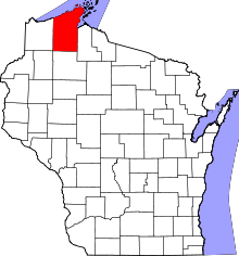 | |
| Village | ||
| Towns | ||
| CDPs | ||
| Unincorporated communities | ||
| Indian reservation | ||
| Footnotes | ‡This populated place also has portions in an adjacent county or counties | |
This article is issued from
Wikipedia.
The text is licensed under Creative Commons - Attribution - Sharealike.
Additional terms may apply for the media files.