Inland Railway
| Inland Railway | |
|---|---|
| Overview | |
| Type | Freight |
| Status | under construction |
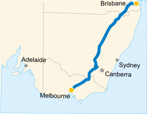
| Termini |
Melbourne Brisbane |
| Website | https://inlandrail.artc.com.au |
| Operation | |
| Planned opening | 2024 |
| Technical | |
| Line length | 1,700 km (1,100 mi) |
| Track gauge | 1,435 mm (4 ft 8 1⁄2 in) |
The Inland Railway is a railway construction project extending from Melbourne to Brisbane along a route west of the mountainous Great Dividing Range. The railway will transport freight between Melbourne and Brisbane with an anticipated transit time of less than 24hrs. Construction of the railway commenced in 2018 and is scheduled to be completed by 2024-2025.[1] The main proponent of the railway line in 2008 was Everald Compton, through the company Australian Transport and Energy Corridor Limited (ATEC).[2]
Overview
The line will be standard gauge, except where it shares the alignment with the narrow gauge of Queensland, in which case the track will be dual gauge. Isolated sections of the line will be built with dual gauge sleepers to facilitate a conversion to dual gauge at a later date. 70% of Inland Rail will be made up of existing rail infrastructure.[1]
The Australian Rail Track Corporation (ARTC) and ATEC are equal partners in a joint venture company called Australian Inland Railway Expressway Pty Ltd (AIRE), which was established to develop the railway line between Victoria and Queensland.[2]
In May 2009 preliminary analysis by the ARTC showed that the cheapest version of the inland railway would cost $2.8 billion to build and would allow freight to be moved from Melbourne to Brisbane in just over 27 hours. Running from Melbourne via Albury to Cootamundra, Parkes, Narromine, Dubbo, Werris Creek and Moree to North Star near Goondiwindi in Queensland, new track would then have to be laid from North Star to Toowoomba and on to Brisbane. The analysis found that if operating by 2020 the economic costs would outweigh the benefits by $1.1 billion, or $860 million if environmental gains were taken into account.[3]
In the 2017 Australian federal budget, the Federal Government earmarked $8.4 billion to build the line. [4]
Sectors
The project is not intended to be constructed by one company or government. Instead, each sector is supposed to be planned and developed separately, with each one having to be economically feasible in its own right. However, some sectors are not viable without others already being in place.
Several connections to be provided across the Great Dividing Range between the inland route and coastal cities and ports, such as Sydney via Goulburn, Newcastle via Ulan or Werris Creek, Brisbane, Gladstone, Rockhampton and Cairns.
Melbourne to Moree
Between Melbourne and Moree, a number of existing railway lines of varying condition and load capacity could provide a connection. In May 2008, the federal government announced a detailed study into the line between Melbourne and Brisbane.[5] That study was expected to select the most viable route. In particular, a decision had to be made between taking the inland railway line via Albury or via Shepparton.[6] Some completely new sections of line were expected to be developed, while other existing lines would be upgraded or completely rebuilt.
Curves & Gradients
- (existing narrow gauge line)
- Curves : 200m
- Gradients: 1 in 48 (2.1%) (either side of Heathcote Junction)
Moree to Toowoomba
Moree is the current terminus of passenger rail services on the Mungindi railway line. Beyond Moree, only wheat trains operate on a branch line to North Star, near the Queensland border. That line previously extended to Boggabilla, which is only a few kilometres from Goondiwindi in Queensland. While Goondiwindi is on a narrow gauge line that connects to Toowoomba via Warwick, these New South Wales and Queensland lines never met.
In April 2008, ATEC announced that it was seeking an unconditional exclusive mandate from the Queensland and New South Wales governments to build a new 350 km standard gauge rail line between Moree and Toowoomba.[7] The proposed route of that line would pass through North Star, turn east on a completely new alignment to Yetman in New South Wales, then north to Yelarbon in Queensland. From there, it would go to Inglewood, then turn north to Millmerran, then through Pittsworth to Toowoomba. While there are existing narrow gauge lines between Yelarbon and Inglewood and between Millmerran and Toowoomba, it is unclear whether it is proposed to use these lines.
Under the proposal, this line was to be completed in 2014. It was estimated that its completion had the potential to reduce the number of trucks travelling along the Newell Highway by 1,000 per day. In 2015, construction was proposed.
Toowoomba to Brisbane
Toowoomba lies at an elevation of 700 metres, which is not particularly high in world terms, but the difficulty of climbing the range from Brisbane at an affordable cost was the reason for the choice of narrow gauge for railways in Queensland, leading to the subsequent break of gauge problems that this caused at the New South Wales border. Route planning for this section is part of the study funded by the federal government.[5] The 2018 plan (to be reviewed) has the rail line halting at Acacia Ridge, 38km from the Port of Brisbane, due to the inability to double-stack containers on the rail line to the port so, initially, some cargo would have to be taken on the final leg to the port by road.
New Tunnel
The section of track from Gowrie to Helidon will include a 6.38 km tunnel through the Great Dividing Range.[1]
Curves & Gradients
- (existing narrow gauge line)
- Curves : 100m (5 chains)
- Gradients: 1 in 50 (2%)
- Tunnels have limited clearances
Future Expansion
Possible future expansion may include sectors from Toowoomba to Darwin.
Toowoomba to Gladstone
Originally called the Dawson Valley railway line, the first sector will be the 210 km Surat Basin railway line between Wandoan and Banana, which is planned to have its detailed route planning and financing completed by the end of 2009 and to be operational in 2012.[8] This line, in conjunction with upgrading of existing lines, will provide a direct link between Toowoomba and Gladstone. The company involved in building that line, Surat Basin Rail Joint Venture, is a joint venture involving ATEC, Industry Funds Management, Anglo Coal, Xstrata Coal and Queensland Rail. It has been granted an unconditional exclusive mandate to construct and operate that line as an open access private railway. This line will initially be built in narrow gauge and without overhead electrification but will be designed to provide for future conversion to dual gauge and electrification.[9]
Banana to Bowen via Emerald
A line has been proposed to connect the Bowen Basin and Surat Basin coal mining regions, providing mines in those areas with access to four ports. The line would connect to the Surat Basin railway line at Banana, extend north-west to Emerald, then north to Bowen.[2]
Mount Isa to Bowen
A line has been proposed to connect the North West Minerals Province around Mount Isa to Bowen.[2]
Mount Isa to Darwin
This sector is proposed to be built between Mount Isa and Tennant Creek, where it would join the Adelaide-Darwin railway to Darwin.[2]
In 2005, a study found that this line was not viable at that time. In July 2008, it was announced that ATEC is again carrying out a study to investigate the viability of constructing this line because two new iron ore mines are being developed north west of Mount Isa and the recently elected Mount Isa council have shown renewed interest in the project.[10]
The Wonarah phosphate deposit, located 250 km east of Tennant Creek, was discovered in 1967 and has been the subject of numerous studies. Up to 2007, the project remained uneconomic due to the world price of phosphate. With rising prices during 2007, the mining lease holder, Minemakers Limited, believed that the project might have become economically viable. The proposed site of the mine is on the Barkly Highway and the route of the proposed Mount Isa to Tennant Creek railway line. The initial plan was to use trucks to transport phosphate to Tennant Creek, where it would be transferred to trains for transport to Darwin.[11] In January 2009, a memorandum of understanding was announced between Minemakers and ATEC for a financial study into the construction of the railway line from the project site to Tennant Creek as an open access private railway.[12][13]
2009
In October, 2009, Minemakers were considering construction of a rail branch from their minesite at Wonarah to a junction with the Adelaide-Darwin railway at Tennant Creek.
2015
In July 2015 the Federal and Northern Territory governments allocated $6m for a study of the Mount Isa - Tennant Creek link.[14]
Freight Depots
A road-rail trans-shipment hub in Charlton, west of Toowoomba, was granted development approval in March 2008.[7]
References
- 1 2 3 Key facts, Australian Rail Track Corporation, retrieved 23 Sep 2017
- 1 2 3 4 5 Australian Transport and Energy Corridor Ltd (April 2008), The Inland Railway: Status Report April, 2008 (PDF), archived from the original (PDF) on 19 July 2008
- ↑ Mark Davis (7 May 2009). "Rail sums do not add up, says study". Sydney Morning Herald. Retrieved 11 May 2009.
- ↑ "$20 billion investment in rail". Minister for Infrastructure and Transport. 9 May 2017. Retrieved 15 September 2017.
- 1 2 Albanese, Anthony (21 May 2008). "Inland rail alignment study underway" (Press release). Archived from the original on 5 October 2009.
- ↑ Daily Advertiser - Economics will decide whether via Albury or via Shepparton
- 1 2 Australian Transport and Energy Corridor Limited (2 April 2008). "Compton asks Bligh and Iemma for mandate to build 900 million dollar border railway by 2014" (PDF) (Press release). Queensland. Archived from the original (PDF) on 21 November 2008.
- ↑ Surat Basin Rail web site
- ↑ Surat Basin Rail - Newsletter 2, August 2008 Archived 20 November 2008 at the Wayback Machine.
- ↑ Looking at economic feasibility of line from Mount Isa to Darwin
- ↑ Minemakers web site for Wonarah Phosphate
- ↑ "Wonarah Railway MOU". Australian Mining. Archived from the original on 1 February 2009.
- ↑ Railway Gazette International May 2009, p25
- ↑ Probert, Oliver (8 July 2015). "Cash granted for Mount Isa-Tennant Creek study". Rail Express. Informa Business Information. Retrieved 2015-10-14.
External links
- Railpage International
- Inland Rail News Summary
- Extensive discussions on the Inland Rail
- Anderson, John (5 April 2001). Australian Australian Inland Rail Expressway (AIRE) Conference (Speech). Dinner Address. Dubbo. Archived from the original on 28 July 2008.
- Howard, John (23 June 1998). "Inland Railway one step closer" (Press release). Archived from the original on 31 August 2000.
- Ove Arup & Partners; TMG International (February 2001), Audit of the Inland Railway Proposal - Parkes to Brisbane Report (PDF), Australian Rail Track Corporation, archived from the original (PDF) on 20 August 2006
- "Support growing for inland railway plan". The Sydney Morning Herald. Fairfax Media. AAP. 7 September 2006. Archived from the original on 22 October 2012.
- The Australian Inland Rail Expressway, AIRE, April 2006, archived from the original on 17 June 2006
- Department of Infrastructure and Regional Development (24 April 2014). "Inland Rail". Department of Infrastructure and Regional Development. Retrieved 28 April 2014.
- Truss, Warren (7 March 2014). "Inland Rail Implementation Group getting things moving" (Press release). Archived from the original on 28 April 2014.
- Australian Rail Track Corporation, Inland Rail Alignment Study, Australian Rail Track Corporation
- Truss, Warren (28 November 2013). "Inland Rail Starts Here and Now" (Press release). Archived from the original on 5 March 2014.
- Truss, Warren; Briggs, Jamie (13 May 2014). "Investing in Freight Rail for the 21st Century" (Press release). Archived from the original on 11 June 2014.
- Will Inland Rail bring migration boom to Toowoomba?
See also
33°08′45″S 148°09′37″E / 33.14591°S 148.16023°ECoordinates: 33°08′45″S 148°09′37″E / 33.14591°S 148.16023°E