Ilm-Kreis

Ilm-Kreis
District

Coat of arms
Country  Germany
State Thuringia
Capital Arnstadt
Government
  District admin. Petra Enders (Ind.)
Area
  Total 843.71 km2 (325.76 sq mi)
Population (31 December 2017)[1]
  Total 108,830
  Density 130/km2 (330/sq mi)
Time zone UTC+01:00 (CET)
  Summer (DST) UTC+02:00 (CEST)
Vehicle registration IK, ARN, IL
Website ilm-kreis.de

Ilm-Kreis is a district in Thuringia, Germany. It is bounded by (from the north and clockwise) the city of Erfurt, the districts of Weimarer Land, Saalfeld-Rudolstadt and Hildburghausen, the city of Suhl, and the districts of Schmalkalden-Meiningen and Gotha. It is named after the river Ilm, flowing through the district.

History

In medieval times the territory was ruled by the counts of Henneberg and the princes of Schwarzburg, two local dynasties. While Ilmenau was ruled by Henneberg, Arnstadt belonged to Schwarzburg. When the Henneberg family became extinct in 1583, Ilmenau was acquired by Saxony. In the meantime the principality of Schwarzburg began to disintegrate and was split up in several tiny states. One of those states (Schwarzburg-Arnstadt) was based in Arnstadt; it was founded in 1574 and existed until 1716, when it fell to Schwarzburg-Sondershausen. This mini state existed until 1920, when the state of Thuringia was founded.

The district was founded in 1920 (under the name Arnstadt); it was divided in 1952 into the districts of Arnstadt and Ilmenau, but reunited in 1994.
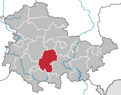
Geography

In its southern portions the district includes parts of the southeastern Thuringian Forest, among them the highest elevation of that mountain chain, including the Großer Beerberg (982 m). To the north the country is sloping away and becomes rather plain, mainly agricultural area.

Coat of arms

The coat of arms displays:
  • the heraldic lion from the principality of Schwarzburg
  • the hen from the county of Henneberg
  • the eagle from the city arms of Arnstadt

Towns and municipalities

Verwaltungsgemeinschaft-free townsand municipalities
  1. Arnstadt
  2. Ilmenau
  3. Stadtilm
  1. Amt Wachsenburg
  2. Wipfratal
Verwaltungsgemeinschaften

1. Geratal

  1. Angelroda
  2. Elgersburg
  3. Geraberg1
  4. Martinroda
  5. Neusiß

2. Großbreitenbach

  1. Altenfeld
  2. Böhlen
  3. Friedersdorf
  4. Gillersdorf
  5. Großbreitenbach1, 2
  6. Herschdorf
  7. Neustadt am Rennsteig
  8. Wildenspring

3. Oberes Geratal

  1. Frankenhain
  2. Gehlberg
  3. Geschwenda
  4. Gossel
  5. Gräfenroda1
  6. Liebenstein
  7. Plaue2

4. Rennsteig

  1. Frauenwald
  2. Schmiedefeld am Rennsteig1
  3. Stützerbach

5. Riechheimer Berg

  1. Alkersleben
  2. Bösleben-Wüllersleben
  3. Dornheim
  4. Elleben
  5. Elxleben
  6. Kirchheim1
  7. Osthausen-Wülfershausen
  8. Rockhausen
  9. Witzleben
1seat of the Verwaltungsgemeinschaft;2town
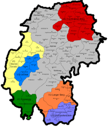
All villages, municipalities and towns in Ilm-Kreis

References

  1. "Bevölkerung der Gemeinden, Gemeinschaftsfreie Gemeinde, erfüllende/beauftragende Gemeinden, Verwaltungsgemeinschaft/Mitgliedsgemeinden in Thüringen". Thüringer Landesamt für Statistik (in German). September 2018.

Coordinates: 50°45′N 11°00′E / 50.75°N 11.0°E / 50.75; 11.0

This article is issued from Wikipedia. The text is licensed under Creative Commons - Attribution - Sharealike. Additional terms may apply for the media files.