Illinois Route 53
| ||||
|---|---|---|---|---|
| Route information | ||||
| Maintained by IDOT | ||||
| Length | 82.02 mi[1] (132.00 km) | |||
| Existed | 1924[2] – present | |||
| Major junctions | ||||
| South end |
| |||
| ||||
| North end |
| |||
| Location | ||||
| Counties | Grundy, Will, DuPage, Cook, Lake | |||
| Highway system | ||||
| ||||

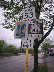
Illinois Route 53 (IL 53) is an arterial north–south state highway in northeast Illinois. IL 53 runs from Interstate 55 (I-55) west of historic U.S. Route 66 (US 66) in Gardner to IL 83 in Long Grove, a distance of 82.02 miles (132.00 km).[1] It mainly cuts through the western suburbs of Chicago, passes through Bolingbrook, Romeoville, Crest Hill and Joliet, merging into I-55 at Gardner.
Route description
IL 53 is one of the few state highways routed along expressways in the state. Before it becomes an expressway, IL 53 starts out in Long Grove going southwest towards Palatine. South of Lake-Cook Road, IL 53 follows Hicks Road, Rand Road (concurrent with U.S. 12) and Dundee Road (concurrent with Illinois 68) through Palatine's northeast side before it joins an expressway that starts un-numbered (technically a spur of 53), one mile (1.6 km) north at Lake-Cook Rd as a bypass of northeast Palatine. The northeast Palatine stretch goes through the Rand and Dundee intersection, one of the country's deadliest intersections in traffic accidents. It forms the other half of the Interstate 290/IL 53 combination in Schaumburg before being routed west onto Biesterfield Road and back south onto Rohlwing Road. Until its first junction with I-55 by Bolingbrook, it remains a mostly 2 to 4 lane road, largely replaced by the I-290 and I-355 combo. In the suburb of Lombard, IL 53 is called Columbine Avenue.
South of the first junction with I-55, IL 53 follows the path of historic Route 66 in Illinois and parallels Interstate 55, entering downtown Joliet, which is about four miles (6 km) east of I-55. IL 53 also passes directly in front of Stateville Correctional Center in Crest Hill, Illinois. From Joliet it follows the original Route 66 alignment to the south. It remains a four-lane divided highway for about 15 miles (24 km), passing through Elwood and the former Joliet Arsenal, part of which is now the Abraham Lincoln National Cemetery and Midewin National Tallgrass Prairie. Route 53 narrows to two lanes just outside Wilmington and crosses the Kankakee River in downtown Wilmington. It then continues southwest through Braidwood and Braceville on its way to Gardner, where it loops around the southern part of town before ending at I-55.
History
SBI Route 53 ran from Romeoville to Long Grove on Rohlwing Road and Hicks Road from 1924 to 1963. From 1963 through 1970, it was routed onto a new freeway from Addison to Arlington Heights and cosigned with I-90 until that was changed to I-290.
In 1967 IL 53 was extended to Gardner, and in 1995 IL 129 was routed onto IL 53 south of Braidwood. This lasted a year until IL 129 was dropped entirely south of Braidwood. Near the northern end, the freeway was extended from Dundee Road to Lake–Cook Road in 1989.[3]
In 1990, with the construction of I-355, IL 53 was moved off the I-290/I-355 combination south of Biesterfield Road and back onto its original alignment.
The Illinois Department of Transportation (IDOT) proposed in 1999 to widen IL 53 south of US 20 (Lake Street) and generally north of I-88 to a five-lane section. Opposition from a citizen group called NIFTI (Neighbors Influencing Fifty-Three improvement) began to lobby for a smaller expansion plan to three lanes. The road south of Lake Street runs through predominantly residential areas and light industry. The term context sensitive design and solutions was introduced to the state of Illinois through the efforts of this group.
Future
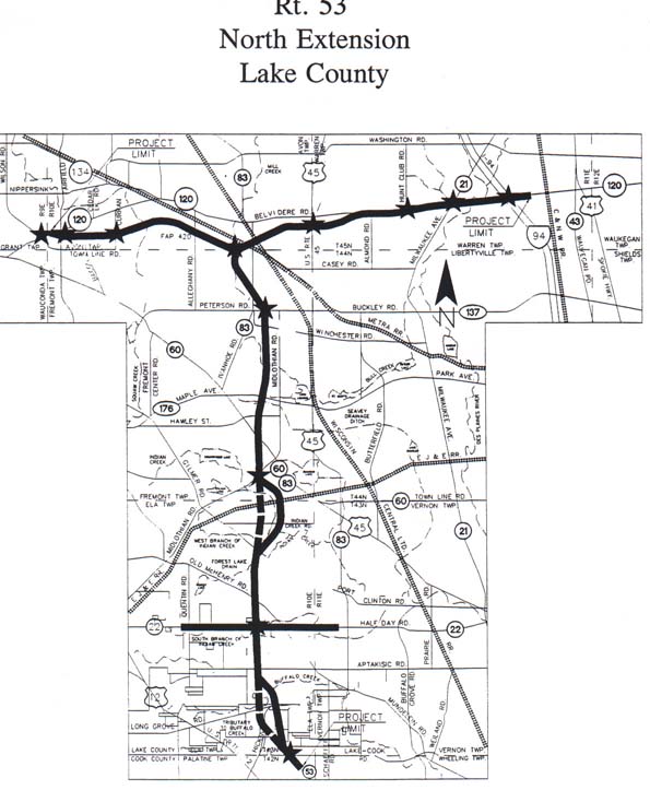
Since the 1960s, IL 53 has been at the center of a major dispute regarding its northern extension (FAP 342) into Lake County. The studied corridor currently runs from the current terminus of the freeway at Lake–Cook Road north to a planned bypass for IL 120 near Grayslake.[4] FAP 342 road signs are posted on roads that would be crossed by the proposed extension, demarking the right-of-way (many villages have not allowed development in the proposed right-of-way). The combined IL 53/IL 120 extension would form a large T-shape in the center of Lake County, with the IL 120 bypass carrying through traffic from US 12 to the Tri-State Tollway around Gurnee.[5]
The extension has been opposed by several organizations, notably the Illinois chapter of the Sierra Club, and many residents of Long Grove, which lies in the path of the highway. The Sierra Club opposes the roadway extension because it would be routed through wetlands and the group has concerns about suburban sprawl and increased pollution.[6]
Proponents of the tollway argue that congestion in Lake County has already reached economically damaging levels, that the existing network of roads in the county is insufficient, and that future projections call for extensive sprawl to continue regardless of the presence of a new highway.[7] In an April 2009 non-binding referendum, registered voters in Lake County approved (76% yes to 24% no) the proposal to extend IL 53, with a 16% turnout rate.[8]
Due to funding constraints with IDOT, the Illinois General Assembly authorized the Illinois State Toll Highway Authority (ISTHA) to plan and construct the IL 53 extension in 1993.[9] The extension is now proposed as a limited-speed (45 mph, 72 km/h) tolled parkway, and it is currently under study by the Illinois Route 53/120 planning council.[10][11]
Major intersections
| County | Location | mi[12] | km | Destinations | Notes |
|---|---|---|---|---|---|
| Grundy | Gardner | 0.0 | 0.0 | Southern terminus of IL 53; I-55 exit 227 | |
| 0.4 | 0.64 | Southwestern end of Historic US 66 concurrency | |||
| Will | Braidwood | 8.8 | 14.2 | ||
| Wilmington | 13.4 | 21.6 | Western terminus of IL 102 | ||
| Joliet | 28.5 | 45.9 | Southern end of US 52 concurrency | ||
| 28.9 | 46.5 | I-80 exits 132A-B. | |||
| 29.3 | 47.2 | Northern end of US 52 concurrency; Southern end of US 6 concurrency | |||
| 30.0 | 48.3 | Eastbound one-way; Northern end of US 6 concurrency | |||
| 30.2 | 48.6 | Westbound one-way | |||
| Joliet–Crest Hill city line | 32.1 | 51.7 | Southern end of IL 7 concurrency | ||
| Crest Hill | 35.1 | 56.5 | Northern end of IL 7 concurrency | ||
| Romeoville | 40.5 | 65.2 | Northwestern end of Historic US 66 concurrency | ||
| Bolingbrook | 41.7 | 67.1 | I-55 exit 267 | ||
| DuPage | Lisle | 49.9 | 80.3 | ||
| 50.5 | 81.3 | I-88 exit 130; westbound exit; eastbound entrance | |||
| Glen Ellyn | 52.5 | 84.5 | |||
| 54.5 | 87.7 | ||||
| Lombard | 58.4 | 94.0 | |||
| Addison | 61.6 | 99.1 | |||
| Itasca | 63.2 | 101.7 | |||
| 64.2 | 103.3 | IL 390 exit 11 | |||
| Cook | Elk Grove Village | 65.6 | 105.6 | Southern end of I–290 concurrency; exit 4. | |
| Schaumburg | 68.4 | 110.1 | Interchange | ||
| 69.4 | 111.7 | Interchange | |||
| Rolling Meadows | 69.9 | 112.5 | Northern end of I–290 concurrency; western terminus of I–290, interchange | ||
| 70.2 | 113.0 | Interchange | |||
| 71.6 | 115.2 | Kirchoff Road | Northbound exit and southbound entrance | ||
| 72.0 | 115.9 | Euclid Avenue | Interchange | ||
| Rolling Meadows–Palatine village line | 73.1 | 117.6 | Interchange | ||
| Palatine–Arlington Heights village line | 74.2 | 119.4 | Palatine Road | Interchange | |
| 75.5 | 121.5 | Northbound exit and southbound entrance | |||
| 76.2 | 122.6 | Interchange | |||
| Cook–Lake county line | 77.4 | 124.6 | Lake Cook Road | Northern end of freeway; unnumbered spur of IL 53 north of IL 68 (Dundee Road) | |
| Lake | Long Grove | 82.02 | 132.00 | Northern terminus of IL 53 | |
1.000 mi = 1.609 km; 1.000 km = 0.621 mi
| |||||
References
- 1 2 Illinois Technology Transfer Center (2006). "T2 GIS Data". Illinois Department of Transportation. Retrieved November 8, 2007.
- ↑ Carlson, Rick (March 15, 2006). "Routes 41 thru 60". Illinois State Highways Page. Retrieved March 23, 2006.
- ↑ Springfield Bureau (May 26, 1988). "Expressway Projects on the List for Chicago Area". Chicago Tribune. Retrieved June 25, 2008.
- ↑ Illinois State Toll Highway Authority. Proposed Alignment for IL Route 53/120 North Extension (PDF) (Map). Illinois State Toll Highway Authority. Archived from the original (PDF) on March 4, 2016. Retrieved May 18, 2012.
- ↑ Rt. 53 North Extension Lake County (Map). Retrieved May 19, 2015.
- ↑ "Guide to Route 53 Extension (FAP 342)". Illinois Sierra Club. Retrieved April 11, 2006.
- ↑ "Home Page". Build 53 Now!. Retrieved April 11, 2006.
- ↑ "Illinois Route 53 Extension Referendum Results, April 7, 2009 Unofficial Results" (PDF). Lake County Government. Archived from the original (PDF) on May 28, 2010. Retrieved August 8, 2010.
- ↑ Ibata, David (August 28, 1993). "Tollway Agency, IDOT to Share Planning for Illinois 53 Extension". Chicago Tribune. Retrieved January 24, 2015.
- ↑ "Illinois Route 53/120 Blue Ribbon Advisory Council". Archived from the original on September 1, 2016.
- ↑ Crews, Julian (May 25, 2017). "Tollway board OKs $25M study for Route 53 extension plan". Chicago: WGN-TV. Retrieved May 25, 2015.
- ↑ Google (February 18, 2017). "Overview Map of IL 53" (Map). Google Maps. Google. Retrieved February 18, 2017.
External links
Route map: