Idaville, Pennsylvania
| Idaville, Pennsylvania | |
|---|---|
| Census-designated place | |
 Idaville, Pennsylvania | |
 Location in Adams County and the state of Pennsylvania. | |
| Coordinates: 40°00′53″N 77°12′10″W / 40.01472°N 77.20278°WCoordinates: 40°00′53″N 77°12′10″W / 40.01472°N 77.20278°W | |
| Country | United States |
| State | Pennsylvania |
| County | Adams |
| Township | Huntington |
| Area | |
| • Total | 0.7 sq mi (1.8 km2) |
| • Land | 0.7 sq mi (1.8 km2) |
| • Water | 0 sq mi (0 km2) |
| Elevation | 804 ft (245 m) |
| Population (2010 census) | |
| • Total | 177 |
| • Density | 255/sq mi (98.4/km2) |
| Time zone | UTC-5 (Eastern (EST)) |
| • Summer (DST) | UTC-4 (EDT) |
| ZIP code | 17337 |
| Area code(s) | 717 |
| GNIS feature ID | 1177683[1] |
| FIPS code | 42-36712 |
Idaville is a census-designated place in Huntington Township, Adams County, Pennsylvania, United States. As of the 2010 census its population was 177.[2] Idaville is served by the Bermudian Springs School District.
Geography
Idaville is located on Pennsylvania Route 34 7 miles (11 km) south of Mount Holly Springs. The town (which starts at the Adams-Cumberland County line) stretches for 1 mile (1.6 km) along Route 34 and is separated from Tyrone Township, adjacent to the south end of the town, by Bermudian Creek.
Idaville is located at 40°00′53″N 77°12′10″W / 40.01472°N 77.20278°W at an elevation of 804 feet (245 m) above sea level.
References
| Wikimedia Commons has media related to Idaville, Pennsylvania. |
- ↑ U.S. Geological Survey Geographic Names Information System: Idaville, Pennsylvania
- ↑ "Geographic Identifiers: 2010 Demographic Profile Data (G001): Idaville CDP, Pennsylvania". U.S. Census Bureau, American Factfinder. Retrieved July 19, 2013.
Municipalities and communities of Adams County, Pennsylvania, United States | ||
|---|---|---|
| Boroughs | 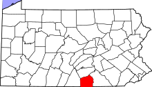 | |
| Townships | ||
| CDPs | ||
| Unincorporated communities | ||
| Ghost town | ||
This article is issued from
Wikipedia.
The text is licensed under Creative Commons - Attribution - Sharealike.
Additional terms may apply for the media files.