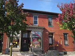
Mount Holly Springs, Pennsylvania
| Mount Holly Springs, Pennsylvania | |
|---|---|
| Borough | |
 Mount Holly Springs | |
| Nickname(s): “Holly” | |
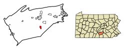 Location of Mount Holly Springs in Cumberland County, Pennsylvania. | |
 Mount Holly Springs Location in Pennsylvania and the United States  Mount Holly Springs Mount Holly Springs (the US) | |
| Coordinates: 40°06′58″N 77°11′12″W / 40.11611°N 77.18667°WCoordinates: 40°06′58″N 77°11′12″W / 40.11611°N 77.18667°W | |
| Country | United States |
| State | Pennsylvania |
| County | Cumberland |
| Government | |
| • Type | Borough Council |
| • Mayor | Scott Boise |
| Area[1] | |
| • Total | 1.45 sq mi (3.76 km2) |
| • Land | 1.36 sq mi (3.52 km2) |
| • Water | 0.09 sq mi (0.24 km2) |
| Elevation | 558 ft (170 m) |
| Population (2010) | |
| • Total | 2,030 |
| • Estimate (2016)[2] | 2,041 |
| • Density | 1,501.84/sq mi (579.81/km2) |
| Time zone | UTC-5 (Eastern (EST)) |
| • Summer (DST) | UTC-4 (EDT) |
| ZIP code | 17065 |
| Area code(s) | 717 |
| FIPS code | 42-51592 |
| Website |
mhsboro |
Mount Holly Springs is a borough in Cumberland County, Pennsylvania, United States 25 miles north of Gettysburg, PA. The population was 2,030 at the 2010 census.[3] It is part of the Harrisburg–Carlisle Metropolitan Statistical Area.
Geography
Mount Holly Springs is located in south-central Cumberland County at 40°6′58″N 77°11′12″W / 40.11611°N 77.18667°W (40.116063, -77.186751),[4] at the northern foot of the South Mountain range. Mountain Creek runs through the center of the borough, exiting the mountains via a water gap between Mount Holly to the west and Keller Hill to the east. Mountain Creek is a tributary of Yellow Breeches Creek, which flows east to the Susquehanna River. The borough limits extend south through the water gap to the Upper Mill area.
According to the United States Census Bureau, the borough has a total area of 1.5 square miles (3.8 km2), of which 1.4 square miles (3.5 km2) is land and 0.1 square miles (0.2 km2), or 6.45%, is water.[3] The borough is surrounded by South Middleton Township but is a separate municipality.
Demographics
| Historical population | |||
|---|---|---|---|
| Census | Pop. | %± | |
| 1880 | 1,256 | — | |
| 1890 | 1,190 | −5.3% | |
| 1900 | 1,328 | 11.6% | |
| 1910 | 1,272 | −4.2% | |
| 1920 | 1,109 | −12.8% | |
| 1930 | 1,140 | 2.8% | |
| 1940 | 1,260 | 10.5% | |
| 1950 | 1,701 | 35.0% | |
| 1960 | 1,840 | 8.2% | |
| 1970 | 2,009 | 9.2% | |
| 1980 | 2,068 | 2.9% | |
| 1990 | 1,925 | −6.9% | |
| 2000 | 1,925 | 0.0% | |
| 2010 | 2,030 | 5.5% | |
| Est. 2016 | 2,041 | [2] | 0.5% |
| Sources:[5][6][7] | |||
As of the census[6] of 2000, there were 1,925 people, 836 households, and 541 families residing in the borough. The population density was 1,276.8 people per square mile (492.2/km²). There were 926 housing units at an average density of 614.2 per square mile (236.8/km²). The racial makeup of the borough was 97.82% White, 0.88% African American, 0.05% Native American, 0.52% Asian, 0.31% from other races, and 0.42% from two or more races. Hispanic or Latino of any race were 1.19% of the population.
There were 836 households, out of which 31.3% had children under the age of 18 living with them, 50.1% were married couples living together, 10.4% had a female householder with no husband present, and 35.2% were non-families. 29.4% of all households were made up of individuals, and 10.4% had someone living alone who was 65 years of age or older. The average household size was 2.30 and the average family size was 2.86.
In the borough the population was spread out, with 24.5% under the age of 18, 6.5% from 18 to 24, 34.1% from 25 to 44, 22.6% from 45 to 64, and 12.3% who were 65 years of age or older. The median age was 36 years. For every 100 females, there were 100.3 males. For every 100 females age 18 and over, there were 98.6 males.
The median income for a household in the borough was $40,625, and the median income for a family was $48,333. Males had a median income of $33,731 versus $25,262 for females. The per capita income for the borough was $19,229. About 5.4% of families and 6.0% of the population were below the poverty line, including 12.9% of those under age 18 and 6.0% of those age 65 or over.
Points of interest
- Amelia S. Givin Free Library, an example of Richardsonian Romanesque architecture, housing a collection of the spiral fretwork patented by Moses Y. Ransom.[8]
Notable people
- Sid Bream played first base in Major League Baseball. He grew up in Mount Holly.[9]
References
- ↑ "2016 U.S. Gazetteer Files". United States Census Bureau. Retrieved Aug 13, 2017.
- 1 2 "Population and Housing Unit Estimates". Retrieved June 9, 2017.
- 1 2 "Geographic Identifiers: 2010 Census Summary File 1 (G001): Mount Holly Springs borough, Pennsylvania". U.S. Census Bureau, American Factfinder. Retrieved June 18, 2015.
- ↑ "US Gazetteer files: 2010, 2000, and 1990". United States Census Bureau. 2011-02-12. Retrieved 2011-04-23.
- ↑ "Census of Population and Housing". U.S. Census Bureau. Retrieved 11 December 2013.
- 1 2 "American FactFinder". United States Census Bureau. Retrieved 2008-01-31.
- ↑ "Incorporated Places and Minor Civil Divisions Datasets: Subcounty Resident Population Estimates: April 1, 2010 to July 1, 2012". Population Estimates. U.S. Census Bureau. Archived from the original on 17 June 2013. Retrieved 11 December 2013.
- ↑ on July–September 15, 1885.
- ↑ Bream fever
External links
| Wikimedia Commons has media related to Mount Holly Springs, Pennsylvania. |
Municipalities and communities of Cumberland County, Pennsylvania, United States | ||
|---|---|---|
| Boroughs | 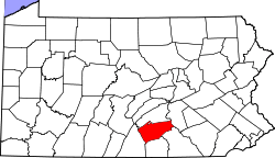 | |
| Townships | ||
| CDPs | ||
| Unincorporated communities | ||
| Footnotes | ‡This populated place also has portions in an adjacent county or counties | |