Fairplay, Pennsylvania
| Fairplay | |
| Unincorporated community | |
| Country | United States |
|---|---|
| State | Pennsylvania |
| County | Adams |
| Township | Freedom Township [1] |
| Elevation | 515 ft (157 m) [2] |
| Coordinates | 39°44′32″N 077°17′09″W / 39.74222°N 77.28583°WCoordinates: 39°44′32″N 077°17′09″W / 39.74222°N 77.28583°W [2] |
| Timezone | EST (UTC-5) |
| - summer (DST) | EDT (UTC-4) |
| ZIP code | 17325 |
| Area code | 717 |
| GNIS feature ID | 1174458 [2] |
 Location of Fairplay in Pennsylvania | |
Fairplay is a populated place in Adams County, Pennsylvania, United States.[2] It is located between the Gettysburg Battlefield and the Mason–Dixon line at the intersection of U.S. Route 15 in Pennsylvania and the Emmitsburg Road near Marsh Creek, in Freedom Township.[1] Moritz' Tavern at the intersection was the site of General John F. Reynolds' headquarters the night before the Battle of Gettysburg.
References
- 1 2 "Topographic map of showing Fairplay in Freedom Township, near border with Cumberland Township". USGS Adams County Township Maps. USGS. Retrieved June 23, 2013. External link in
|work=(help) - 1 2 3 4 "Fairplay (Adams County, Pennsylvania)". Geographic Names Information System. United States Geological Survey. Retrieved June 23, 2013.
Municipalities and communities of Adams County, Pennsylvania, United States | ||
|---|---|---|
| Boroughs | 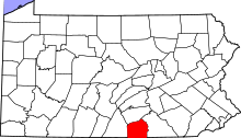 | |
| Townships | ||
| CDPs | ||
| Unincorporated communities | ||
| Ghost town | ||
This article is issued from
Wikipedia.
The text is licensed under Creative Commons - Attribution - Sharealike.
Additional terms may apply for the media files.