Hyde Park, Los Angeles
| Hyde Park | |
|---|---|
| Neighborhood of Los Angeles | |
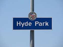 "Hyde Park" city sign located at Crenshaw Boulevard & 79th Street. | |
 Hyde Park Location within Central Los Angeles | |
| Coordinates: 33°58′50″N 118°19′51″W / 33.9806°N 118.3309°WCoordinates: 33°58′50″N 118°19′51″W / 33.9806°N 118.3309°W | |
| Country |
|
| State |
|
| County |
|
| City | Los Angeles |
| Time zone | Pacific |
| Zip Code | 90043 |
| Area code(s) | 323 |

Hyde Park is a neighborhood in the South Los Angeles region of Los Angeles, California. Formerly a separate city, it was incorporated into Los Angeles in 1923.
History
Hyde Park is one of the oldest neighborhoods in the city of Los Angeles. It was "laid out as a town" in 1887[1] as a stop on the Atchison, Topeka and Santa Fe Railway's Harbor Subdivision, which ran from Downtown Los Angeles to the port at Wilmington in a westward loop.
It was incorporated as a city in 1922 and had its own government. However, on May 17, 1923, its 1.2 square miles (3.1 km2) was consolidated with the larger city of Los Angeles after a favorable vote by Hyde Park residents. The city of Hyde Park was bordered by 60th Street on the north, Van Ness (now 8th Avenue) on the east, Florence Avenue on the south, and West Boulevard on the west.[2]
Geography
Hyde Park's street and other boundaries are: West Vernon Avenue on the north, South Van Ness Avenue on the east and the Los Angeles city boundary on the south and west.[3][4]
According to the Mapping L.A. project of the Los Angeles Times, Hyde Park touches Leimert Park on the north, Vermont Square on the northeast, Chesterfield Square on the east, Manchester Square on the southeast; Inglewood on the south and southwest, and View Park-Windsor Hills on the west and northwest.[5]
Population
A total of 36,635 people lived in the neighborhood's 2.88 square miles, according to the 2000 U.S. census—averaging 12,700 people per square mile, about the same as the population density in the city as a whole. The median age was 31, also about the same as the rest of the city.[3]
Within the neighborhood, African Americans comprise 66% of the population, with Latinos at 27.2%, White 3%; Asian 1.2% and other 3.6%. Mexico and El Salvador were the most common places of birth for the 19.5% of the residents who were born abroad, considered a low percentage of foreign-born when compared with the city or county as a whole.[3]
The median household income in 2008 dollars was $39,460, considered average for both the city and county. The percentage of households earning $20,000 or less was high, compared to the county at large. The average household size of 2.8 people was also average. Renters occupied 53.3% of the housing units, and homeowners occupied the rest.[3]
In 2000, there were 2,474 families headed by single parents, or 28.5%, a rate that was high for the county and the city. There were 2,237 veterans, or 8% of the population, considered high when compared with the city overall.[3]
- These are the ten neighborhoods in Los Angeles County with the largest percentage of black residents:[6]
- View Park-Windsor Hills, California, 86.5%
- Gramercy Park, Los Angeles, 86.4%
- Leimert Park, Los Angeles, 79.6%
- Manchester Square, Los Angeles, 78.6%
- Baldwin Hills/Crenshaw, Los Angeles, 71.3%
- Ladera Heights, California, 71%
- Hyde Park, Los Angeles, 66%
- Chesterfield Square, Los Angeles, 58.6%
- West Rancho Dominguez, California, 57.6%
- Westmont, California, 57.5%
Infrastructure
Parks and recreation
The Van Ness Recreation Center is the only park in the Hyde Park neighborhood. It has an indoor gymnasium, auditorium, barbecue pits, outdoor basketball courts and a baseball diamond. [4]
Education
Hyde Park residents aged 25 and older holding a four-year degree amounted to 12.2% of the population in 2000, considered low when compared with the city and the county as a whole, but the percentages of residents aged 25 and older with a high school diploma and college bachelor's degree was considered high for the county.[3]
Schools
Schools within the Hyde Park boundaries are:[4][7]
- Crenshaw Senior High School, LAUSD, 5010 11th Ave
- Alliance William and Carol Ouchi Academy High, LAUSD charter, 5356 South Fifth Avenue
- View Park Preparatory Accelerated High, LAUSD charter, 5701 South Crenshaw Boulevard
- Crenshaw Arts-Technology Charter High, LAUSD, 4120 11th Avenue
- Whitney Young Continuation, LAUSD, 3051 West 52nd Street
- Golden Day Schools, private K-12, 4508 Crenshaw Boulevard
- KIPP Academy of Opportunity, LAUSD charter middle, 7019 South Van Ness Avenue
- Today's Fresh Start Charter, LAUSD, 4514 Crenshaw Boulevard
- Angeles Mesa Elementary, LAUSD, 2611 West 52nd Street
- View Park Preparatory Accelerated Charter Middle, LAUSD, 5749 South Crenshaw Boulevard
- Marcus Garvey Elementary, private, 5760 Sixth Avenue
- Fifty-Ninth Street Elementary, LAUSD, 5939 Second Avenue
- YES Academy, LAUSD elementary, 3140 Hyde Park Boulevard
- Alliance Renee and Meyer Luskin Academy High School, 2941 70th Street
References
- ↑ Pitt, Leonard; Pitt, Dale (1997). Los Angeles A to Z. p. 216. ISBN 0520202740.
- ↑ Annexation and Detachment Map, City of Los Angeles, partial copyright by Thomas Brothers Maps, 2004.
- 1 2 3 4 5 6 "Hyde Park", Mapping L.A., Los Angeles Times
- 1 2 3 The Thomas Guide, 2006, pp. 673 and 703.
- ↑ "South L.A.", Mapping L.A., Los Angeles Times
- ↑ "Black", Mapping L.A. at Los Angeles Times
- ↑ "Hyde Park Schools", Mapping L.A., Los Angeles Times
External links
| Wikimedia Commons has media related to Hyde Park, Los Angeles. |
- Hyde Park Branch of the Los Angeles Public Library
- Hyde Park crime map and statistics, Los Angeles Times

| By topic |  | |
|---|---|---|
| Government | ||