Gramercy Park, Los Angeles
| Gramercy Park | |
|---|---|
| Neighborhood of Los Angeles | |
| Country |
|
| State |
|
| County |
|
| City | Los Angeles |
| Time zone | PST |
| Area code(s) | 323 |
The Gramercy Park neighborhood of Los Angeles is a 1.13-square-mile district in Los Angeles, California, within the South Los Angeles region. According to the 2000 United States census, Gramercy Park's population of 11,000+ residents are largely African Americans (86.4%), elderly people and military veterans.[1] City signs around the borders of the neighborhood indicate that it is also called West Park Terrace.
Geography
Description
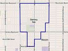
The Gramercy Park neighborhood touches Manchester Square on the north, Westmont on the east and south, and Inglewood on the west.[2] It is bounded by Manchester Boulevard on the north, Normandie Avenue and the Los Angeles city line on the east, and the Los Angeles city border on the south and west.[1][3]
Population
A total of 10,047 people lived in the neighborhood's 1.13 square miles, according to the 2000 U.S. census—averaging 8,859 people per square mile, about an average population density in both the city and the county. In 2008 the city estimated its population had grown to 11,173.[1]
The median age was 36, considered old for the city but about average for the county, and the percentages of residents aged 50 and older was among the county's highest.[1]
Within the neighborhood, African Americans made up 86.4% of the population—the highest percentage among Los Angeles County neighborhoods or cities—and Latinos made up 11.5% of the population. Other ethnicities were white, 0.8%; Asian, 0.4%; and other, 0.9%. Mexico and Jamaica were the most common places of birth for the 9.3% of the residents who were born abroad, a low percentage of foreign-born when compared with the city or county as a whole.[1]
The median household income in 2008 dollars was $57,983, considered average for both the city and county. The percentage of households earning $40,000 to $60,000 was high, compared to the county at large. The average household size of 2.8 people was about average. Homeowners occupied 70.4% of the housing units, and renters occupied the rest.[1]
The percentages of divorced and widowed people were among the county's highest, and there were 562 families headed by single parents, or 21.9%, a rate that was among the county's highest.[1]
There were 939 veterans, or 13.1% of the population, considered high compared with the city and the county overall.[1]
- These are the ten neighborhoods in Los Angeles County with the largest percentage of black residents:[4]
- View Park-Windsor Hills, California, 86.5%
- Gramercy Park, Los Angeles, 86.4%
- Leimert Park, Los Angeles, 79.6%
- Manchester Square, Los Angeles, 78.6%
- Baldwin Hills/Crenshaw, Los Angeles, 71.3%
- Ladera Heights, California, 71%
- Hyde Park, Los Angeles, 66%
- Chesterfield Square, Los Angeles, 58.6%
- West Rancho Dominguez, California, 57.6%
- Westmont, California, 57.5%
Education
Gramercy Park residents aged 25 and older holding a four-year degree amounted to 14.9% of the population, an average percentage for both the city and the county. The percentage of residents of that age having some college education was considered high.[1]
Schools within the boundaries of the Gramercy Park neighborhood are:[5]
- La Salle Elementary School (LAUSD), 8715 La Salle Avenue
- Saint Eugene Elementary School (private), 9521 South Haas Avenue
- Manhattan Place Elementary School (LAUSD), 1850 West 96th Street
Recreation and parks
References
- 1 2 3 4 5 6 7 8 9 "Exposition Park," Mapping L.A., Los Angeles Times
- ↑ "South Los Angeles," Mapping L.A., Los Angeles Times
- 1 2 3 The Thomas Guide, 2006, page 703
- ↑ "Black", Mapping L.A. at Los Angeles Times
- ↑ "Gramercy Park Schools," Mapping L.A., Los Angeles Times
- ↑ Saint Andrews Recreation Center
- ↑ Los Angeles City Department of Recreation and Parks
- ↑ Los Angeles County Department of Parks and Recreation
External links
Coordinates: 33°49′16″N 118°19′07″W / 33.8212°N 118.3187°W

| By topic |  | |
|---|---|---|
| Government | ||