Hustopeče
| Hustopeče | |||
| Town | |||
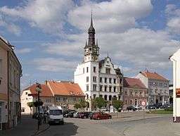 Main square with town hall | |||
|
|||
| Country | Czech Republic | ||
|---|---|---|---|
| Region | South Moravian | ||
| District | Břeclav | ||
| Commune | Hustopeče | ||
| Elevation | 215 m (705 ft) | ||
| Coordinates | 48°56′27.05″N 16°44′15.44″E / 48.9408472°N 16.7376222°ECoordinates: 48°56′27.05″N 16°44′15.44″E / 48.9408472°N 16.7376222°E | ||
| Area | 24.53 km2 (9.47 sq mi) | ||
| Population | 5,937 (2005) | ||
| Density | 242/km2 (627/sq mi) | ||
| First mentioned | 13th century | ||
| Mayor | Hana Potměšilová | ||
| Timezone | CET (UTC+1) | ||
| - summer (DST) | CEST (UTC+2) | ||
| Postal code | 693 01 | ||
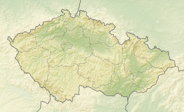 Location in the Czech Republic | |||
| Statistics: statnisprava.cz | |||
| Website: www.hustopece-city.cz | |||


Hustopeče (Czech pronunciation: [ˈɦustopɛtʃɛ]; German: Auspitz) is a town of Břeclav District in the South Moravian Region of the Czech Republic. It is the centre of the rural Hustopečsko region, known for fruit and wine growing.
Geography

The town is situated in the historic Moravia region, within the southern foothils of the Ždánice Forest range. The town centre is located about 25 km (16 mi) northwest of the district capital Břeclav. In the northeast, the D2 motorway runs from Brno to the border with Slovakia.
About 5,800 inhabitants live in the municipal area.
History
Hustopeče was first mentioned in a 1247 deed, at the time when the Czech Přemyslid dynasty ruled the Margraviate of Moravia. From the 11th century onwards, the area around Mikulov and Znojmo had been settled by German colonists in the course of the Ostsiedlung movement, mainly descending from the Austrian lands in the southwest. Local nobles and feudal lords were followers of King Ottokar II of Bohemia. When in 1306 the male line of the Přemyslids became extinct, Hustopeče passed to Queen Elizabeth of Bohemia; she granted the estates to the Cistercian nuns in Brno.
In 1572 Emperor Maximilian II officially vested Hustopeče with town privileges. During the 16th century, it developed as an important trade centre on the route from Prague to Hungary. It also became a centre of radical Anabaptists and the Hutterite movement. Upon the 1620 Battle of White Mountain, the Habsburg rulers enacted several Counter-Reformation measures to enforce the return of the citizens to the Catholic faith. The town was repeatedly looted and burned during the Thirty Years' War; in 1643 and 1645, it was devastated by Swedish troops under Field Marshal Lennart Torstensson. During the Great Turkish War and the 1683 Battle of Vienna, Hustopeče was occupied by Ottoman forces.
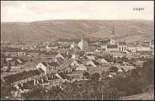
In 1756 the Piarists established a first gymnasium here. On 18 July 1894, Hustopeče received access to a Lokalbahn branch line to Šakvice and the Emperor Ferdinand Northern Railway from Vienna to Prague. Until 1918, AUSPITZ - HUSTOPEČE[1] (AUSPITZ until the mid-19th century) was part of the Austrian monarchy (Austrian side after the Compromise of 1867), in the district with the same name, one of the 34 Bezirkshauptmannschaften in the Cisleithanian Margraviate of Moravia.[2] According to a 1910 census, most of its inhabitants were ethnic Germans.
After World War I and the dissolution of Austria-Hungary, large parts of the South Moravian region were claimed by the newly established Republic of German-Austria; nevertheless, according to the 1919 Treaty of Saint-Germain, Hustopeče and it surroundings passed the First Czechoslovak Republic. After the Munich Agreement in 1938, it was occupied by Nazi Germany and incorporated into Reichsgau Niederdonau as one of the municipalities in Sudetenland. After World War II, Hustopeče returned to Czechoslovakia and the remaining German-speaking population was expelled accoridng to the Beneš decrees.
Church of Saint Wenceslaus
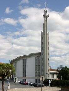
The town skyline was dominated by the Gothic parish church dedicated to Saint Wenceslaus and Agnes of Bohemia, built in the late 12th century. Though renovated several times, its 74 m (243 ft) high steeple collapsed in 1961, which damaged the church's structure greatly. One year later, the Communist government ordered the building to be torn down.
After the Velvet Revolution, a new futuristic church was built on the site of the old one between 1990 and 1994, and was designed by L. Kolka. The new St. Wenceslaus' church has a 47 m (154 ft) high steeple (52 m (171 ft) including its cross).
Notable people
- Tomáš Garrigue Masaryk (1850–1937), politician and statesman, lived in Hustopeče between 1861 and 1868; his parents' graves are located in the town cemetery.
Events
Each year in late January, Hustopece is host to the world's best high jumpers competing in the Moravia High Jump Tour. The narrow basketball gymnasium in Hustopece routinely produces world-leading jumps by both men and women.
References
External links
| Wikimedia Commons has media related to Hustopeče. |
- Municipal website (in Czech)
- Monuments of Hustopeče (in Czech, pdf)
| Authority control |
|---|