Huntly, New Zealand
| Huntly Rahui-Pōkeka (Māori) | |
|---|---|
| Minor urban area | |
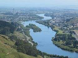 Waikato River, Huntly and Huntly power station from Hakarimatas in 2012 | |
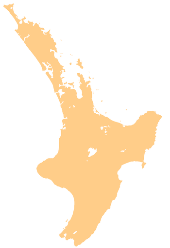 Huntly Huntly's location within the North Island | |
| Coordinates: 37°33.5′S 175°9.5′E / 37.5583°S 175.1583°ECoordinates: 37°33.5′S 175°9.5′E / 37.5583°S 175.1583°E | |
| Country | New Zealand |
| Region | Waikato |
| Territorial authority | Waikato District |
| Elevation | 15 m (49 ft) |
| Population (June 2017)[1] | |
| • Total | 8,070 |
| Postcode(s) | 3700 |
Huntly (Māori: Rahui-Pōkeka) (population 8,070[1]) is a town in the Waikato district and region of the North Island of New Zealand. It is on State Highway 1, 95 kilometres south of Auckland and 32 kilometres north of Hamilton. It is situated on the North Island Main Trunk (NIMT) railway and straddles the Waikato River. It is within the Waikato District which is in the northern part of the Waikato Region local government area.
Huntly was called Rahui Pokeka when migrants settled the town some time in the 1850s. The Huntly name was adopted in the 1870s when the postmaster named it after Huntly, Aberdeenshire in Scotland. He used an old 'Huntley Lodge' stamp to stamp mail from the early European settlement. The 'Lodge' was later dropped and the spelling changed to also drop the additional 'e'.[2]
The railway from Auckland reached Huntly in 1877, when the Huntly railway station was opened.
Major industries
Huntly Power Station is a large gas/coal-fired power station, prominently situated on the western bank of the Waikato River. It is New Zealand's largest thermal power station, situated in the area which is New Zealand's largest producer of coal, producing over 10,000 tonnes a day. [3]
Huntly is also surrounded by farmland and lakes (many of them former open-pit mines) which are used for coarse fishing, yachting and waterskiing.
Coal
The Waikato coalfield is formed of 30 -35m year old Eocene-Oligocene rocks. The lowest coal measures are the Taupiri Seams, worked at Rotowaro, the upper Kupakupa and Renown Seams having been largely worked out.[4]
The area has a very long history of coal mining, with both open cast and classical mines operating or having operated here.[5] The major New Zealand clients for the mined coal are the power station and the New Zealand Steel mill at Glenbrook.
The first coal to be mined was half a ton at Taupiri in 1849,[6] followed by 32 tons in 1850,[7] opposite Kupa Kupa, about 5 km (3.1 mi) south of Huntly,[8] and coal was also discovered at Papahorohoro, near Taupiri.[9] However, it wasn't being exploited when the geologist, Ferdinand von Hochstetter, visited it in 1859.[10] It was used to fuel steamers during the 1863 invasion of the Waikato.[11] Kupakupa mine was started in 1864[12] and produced 11,000 tons by 1866.[13] The area was confiscated in 1865.[14] It was auctioned by government in 1867.[15]
Taupiri Coal Co was producing 1,300 tons a month by 1879,[16] up from 5,300 tons a year in 1878.[17] A mine across the river from Kupakupa was opened in 1879.[18]
After the Pukemiro railway opened in 1915, mines opened at Pukemiro, Glen Afton, Rotowaro, Waikōkōwai and Renown. Open cast mining began west of Huntly during World War 2, and later an opencast mine at Kimihia.[19]
O’Reilly’s Opencast Mine
This is the only remaining mine operating in Huntly (off Riverview Rd),[20] producing 24,708 tonnes in 2016.[21] It is a privately owned mine, opened in 1957[22] and mainly selling to New Zealand Steel.[23] It, Puke Mine and Rotowaro are the only mines still open in the Huntly area.[21]
Huntly East Coalmine
Solid Energy closed this last Huntly mine on 22 October 2015,[24] saying it was losing $500,000 a month. It opened in 1978, produced a peak of 465,000 tonnes in 2004[25] and was digging about 450,000 tonnes a year[26] until production was cut to 100,000 tonnes in September 2013.[25] The mine entrance was in Huntly East, but by 2012 all mining was west of the Waikato, with roadways 150 metres below the river, the two 8 to 20 metre thick sub-bituminous seams being 150 to 400 metres deep. In 2012 it was estimated that 7 million tonnes of recoverable coal remained in the consented mining areas, with a further 12 million available for future expansion. Coal was mined by remote-controlled continuous miners and taken to the entrance in shuttle cars and then by conveyor belt. It continued to Glenbrook via the Kimihia branch railway and the NIMT. It employed about 200 in 2012,[26] but was down to 68 at closure.[27]
Kimihia Wetland was created to cope with subsidence and treat water from Huntly East Mine.[26]
Bricks
Clay suited for bricks lies on top of some of the coal deposits.[28] Brick making began in 1884, Huntly Brick and Fireclay was established in 1911 and Shinagawa Refractories continues on the site[29] at the south end of the town.[30] Nearby, Clay Bricks operate a brickworks.[31]
Rugby league
Huntly has a proud rugby league history – at one time the town had four rugby league clubs: Taniwharau, Huntly South, Huntly United and Rangiriri Eels. Taniwharau has been one of the most successful clubs having won 11 straight Waikato premierships during the 1970s and 1980s. Taniwharau also won the inaugural Waicoa Bay championship in 2002 and again in 2007 a year in which they went through the season unbeaten; a feat that has never been achieved before at the Waikato premier level. The Waicoa Bay championship is a combined rugby league competition involving clubs from Waikato, Bay of Plenty and Coastlines.
A number of Kiwi players have come out of Huntly including pre war players Tom Timms, Richard Trautvetter and Len Mason who also, after the 1926 Kiwi tour of Great Britain finished his playing career at Wigan, playing a record 365 games in 9 years including a winning Challenge Cup final at Wembley in 1929. Post war players include Albert Hambleton, Reg Cooke, Graeme Farrar, Roger Tait, Ted Baker, Paul Ravlich, Tawera Nikau (Rangiriri) and, more recently, Wairangi Koopu (Taniwharau) and Lance Hohaia (Taniwharau). Other Kiwi players to come out of Huntly include Andy Berryman, Don Parkinson, Rick Muru, Kevin Fisher and Vaun O'Callaghan.[32] The town has also produced numerous NZ Māori Rugby league representatives and two international referees; Arthur Harlock and Roland (Roly) Avery.
Tainui
Huntly and its surrounding area is steeped in Māori history and falls within the rohe (tribal area) of Waikato-Tainui of the Tainui waka confederation. Ngati Mahuta and Ngati Whawhakia are the subtribes in the Huntly area. There are a number of marae in and around Huntly: Waahi Pa, Te Kauri, Kaitimutimu, Te Ohaaki and further north, Maurea and Horahora. Waahi Pa was the home of the late Māori Queen Dame Te Atairangikaahu and is still the home of her son, the Māori King Tuheitia Paki.
Huntly is home to Rakaumanga Kura which became one of the first bilingual schools (Māori/English) in New Zealand in 1984. Rakaumanga became a kura kaupapa (total immersion, Māori as its first language) in 1994 and is now known by the name Te Whare Kura o Rakaumangamanga. The school was first established as a native school in 1896.
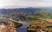
Bridges
.jpg)
Rail Bridge After a first pile driving ceremony in 1911,[33] the punt (opened 18 Sep 1894)[34] was replaced in 1915 by a road/rail bridge serving the Pukemiro railway.[35]
Tainui Bridge is a 7-span bowstring-arch[36] for road traffic opened in 1959, when the 1915 bridge became rail only, and a footbridge was attached to its side.[37] Tainui Bridge was strengthened in 2005[36] to allow 500 tonne turbines[38] to be carried to the Power Station,[39] work which gained an award.[40] Seismic strengthening was done in 2011.[36] The bridge was repainted in 2016.[41]
A footbridge across Shand Lane, the 1978 SH1 bypass[42] and NIMT links Glasgow St with Main St.[43] The 14-tonne central span was raised from 4.8 to 5.25m in 2010 to provide clearance for Te Uku construction trucks. It was also closed twice in 2015, firstly for repainting,[44] then again when the arm of an excavator on a truck hit the bridge,[45] requiring also temporary closure of SH1.[46] Cameras and extra rails have been installed to improve safety,[47] following stone throwing.[48]
References
- 1 2 "Subnational Population Estimates: At 30 June 2017 (provisional)". Statistics New Zealand. 24 October 2017. Retrieved 24 October 2017. For urban areas, "Subnational population estimates (UA, AU), by age and sex, at 30 June 1996, 2001, 2006-16 (2017 boundary)". Statistics New Zealand. 24 October 2017. Retrieved 24 October 2017.
- ↑ About Huntly – History Archived 31 July 2007 at the Wayback Machine. (from the 'huntly.co.nz' website. Accessed 2008-02-20.)
- ↑ Coal Overview (from the 'minerals.co.nz' website. Accessed 2008-02-20.)
- ↑ "The Waikato Coal Region". www.solidenergy.co.nz. Retrieved 2018-02-03.
- ↑ Huntly (from Te Ara: The Encyclopedia of New Zealand, 1966 Edition. Accessed 2008-02-20.)
- ↑ "Auckland's First Coal". New Zealand Herald. 1925-07-02. p. 6. Retrieved 2018-02-08.
- ↑ "The New Zealander". 1850-11-09. p. 2. Retrieved 2018-02-03.
- ↑ "routes and surveys by Ferdinand von Hochstetter, 1859". www.aucklandcity.govt.nz. Retrieved 2018-02-03.
- ↑ "The New-Zealander". 1850-02-23. p. 2. Retrieved 2018-02-03.
- ↑ "Lecture on the Geology of the Province of Auckland. by Dr. Ferdinand Hochstetter". Nelson Examiner and New Zealand Chronicle. 1859-08-03. p. 1. Retrieved 2018-02-03.
- ↑ "The Daily Southern Cross". Daily Southern Cross. 1863-12-22. p. 3. Retrieved 2018-02-03.
- ↑ "The Waikato War". New Zealander. 1864. p. 6. Retrieved 2018-02-03.
- ↑ "Lecture on the Waikato by Major Heaphy". Daily Southern Cross. 1866-07-16. p. 4. Retrieved 2018-02-03.
- ↑ "Proclamation of Native Lands Under the New Zealand Settlements Act". Daily Southern Cross. 1865-06-21. p. 5. Retrieved 2018-02-03.
- ↑ "Page 5 Advertisements Column 1". New Zealand Herald. 1867-07-19. p. 5. Retrieved 2018-02-03.
- ↑ "Taupiri Coal Mines". New Zealand Herald. 1879-04-11. p. 5. Retrieved 2018-02-03.
- ↑ "Facts Culled from the Public Works Statement". Colonist. 1878-09-12. p. 2. Retrieved 2018-02-03.
- ↑ "Parliament". New Zealand Times. 1879-12-10. p. 2. Retrieved 2018-02-03.
- ↑ Taonga, New Zealand Ministry for Culture and Heritage Te Manatu. "4. – Waikato places – Te Ara Encyclopedia of New Zealand". teara.govt.nz. Retrieved 2018-02-03.
- ↑ "Google Maps". Retrieved 2018-02-05.
- 1 2 Minerals, New Zealand Petroleum and. "Operating coal mine production figures". New Zealand Petroleum and Minerals. Retrieved 2018-02-05.
- ↑ "Connecting People Through News". www.pressreader.com. Retrieved 2018-02-05.
- ↑ "O'Reilly's Opencast | New Zealand Mining Investment Opportunities". www.miningnz.co.nz. Retrieved 2018-02-05.
- ↑ "Coal mining stops at Huntly East". NZ Railway Observer: 195 (photo of last train on 21 Oct on page 199). December 2015.
- 1 2 "Solid Energy proposes to halt production at Huntly East Mine in New Zealand". Mining Technology. Retrieved 2015-12-11.
- 1 2 3 "Huntly East Mine" (PDF). Solid Energy. May 2012.
- ↑ "'Other mines will sell' – Solid Energy". Stuff. Retrieved 2015-12-11.
- ↑ "COAL IN THE WAIKATO: A 20FT SEAM BEING WORKED OPEN-CAST AT HUNTLY". www.aucklandcity.govt.nz. 28 May 1914. Retrieved 2018-03-01.
- ↑ Taonga, New Zealand Ministry for Culture and Heritage Te Manatu. "4. – Waikato places – Te Ara Encyclopedia of New Zealand". teara.govt.nz. Retrieved 2018-03-01.
- ↑ "CONTACT | Shinagawa Refractories Australasia". www.shinagawa.com.au. Retrieved 2018-03-01.
- ↑ "Clay Bricks". www.claybricks.co.nz. Retrieved 2018-03-01.
- ↑ Kiwis Roll of Honour A – Z Archived 22 February 2013 at Archive.is
- ↑ "IMPORTANT DAY AT HUNTLY (Waikato Argus, 1911-10-24)". paperspast.natlib.govt.nz National Library of New Zealand. Retrieved 2017-05-14.
- ↑ "HUNTLY. (Waikato Times, 1894-09-18)". paperspast.natlib.govt.nz National Library of New Zealand. Retrieved 2017-06-15.
- ↑ "The Waikato River at Huntly, showing the fine new Ferro-Concrete Bridge and the Old Punt". www.aucklandcity.govt.nz. 30 Oct 1913. Retrieved 2017-05-14.
- 1 2 3 "Tainui Bridge to undergo upgrades". Stuff.co.nz. 2011-02-14. Retrieved 2017-05-16.
- ↑ "History of Huntly". www.huntly.net.nz. Retrieved 2017-05-14.
- ↑ "Project Gallery | Industrial Site Services, NZ". www.iss.co.nz. Retrieved 2017-05-16.
- ↑ "Brian Perry Civil : Projects : Huntly Tainui Bridge". www.brianperrycivil.co.nz. Retrieved 2017-05-16.
- ↑ "Tainui Bridge project takes top contracting award | Scoop News". www.scoop.co.nz. Retrieved 2017-05-16.
- ↑ "Tainui Bridge Repainting". Waikato District Council. Retrieved 2017-05-16.
- ↑ "Highway Information Sheet 01N-0519" (PDF). AucklandMotorways.
- ↑ "Google map of central Huntly". Google Maps. Retrieved 2017-06-01.
- ↑ "Huntly footbridge removed for clean and paint". Stuff. Retrieved 2017-06-01.
- ↑ "Truck hits Huntly footbridge on SH1". Stuff. Retrieved 2017-06-01.
- ↑ "Huntly footbridge reinstalled Sunday night". Waikato District Council. Retrieved 2017-06-01.
- ↑ KiwiRail. "News and press releases - KiwiRail". www.kiwirail.co.nz. Retrieved 2017-06-01.
- ↑ "Huntly rock throwing victim angry". Stuff. Retrieved 2017-06-01.
External links
- Original website for Huntly
- Official Huntly Website
- Alexander Turnbull Library punt c1910, aerial photos of bridges - 1954, Tainui construction 1958, 1961 from west, from north, 1963, 1991 with bypass
- Auckland Weekly News photos - punt in 1913, road/rail bridge - 1911, 1912 , 1913 , 1933 from the air
- River water quality at Huntly Bridge
.jpg)