Yilan Plain
Coordinates: 24°42′56″N 121°47′3″E / 24.71556°N 121.78417°E
| Yilan Plain | |
|---|---|
| 宜蘭平原 | |
 | |
| Location | Yilan County, Taiwan |
| Geology | Plain |
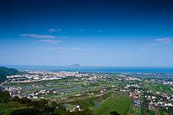
Yilan Plain (Chinese: 宜蘭平原; pinyin: Yilán Píngyuán), also called the Lanyang Plain (蘭陽平原), or historically Kabalan[1] (Chinese: 蛤仔難; Pe̍h-ōe-jī: Kap-á-lān), Kapsulan (蛤仔蘭; Kap-chú-lân), Komalan (噶瑪蘭; Kat-má-lán) is a plain in Yilan County, Taiwan. The plain has an alluvial fan which formed by Lanyang River. The plain was formed in the shape of nearly equilateral triangle. The broad and flat feature of this plan has made transportation so convenient in the region which drew large population to the towns and city in the area.
The plain was inhabited by the Kavalans, an aboriginal group which mostly had migrated to southern places such as Hualien and Taitung.[2][3]
See also
References
- ↑ Campbell, William (1903). "Explanatory Notes". Formosa under the Dutch: described from contemporary records, with explanatory notes and a bibliography of the island. London: Kegan Paul. p. 543. OCLC 644323041.
- ↑ "Landmark of Langyang Plain in Taiwan - Review of National Center for Traditional Arts, Yilan County, Taiwan". Tripadvisor.co.uk. Retrieved 18 October 2017.
- ↑ "Archived copy". Archived from the original on 2016-03-04. Retrieved 2014-04-02.
This article is issued from
Wikipedia.
The text is licensed under Creative Commons - Attribution - Sharealike.
Additional terms may apply for the media files.