Hrčava
| Hrčava | |||
|---|---|---|---|
| Village | |||
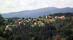 A general view | |||
| |||
 Location in the Czech Republic | |||
| Coordinates: 49°31′30″N 18°50′4″E / 49.52500°N 18.83444°ECoordinates: 49°31′30″N 18°50′4″E / 49.52500°N 18.83444°E | |||
| Country | Czech Republic | ||
| Region | Moravian-Silesian | ||
| District | Frýdek-Místek | ||
| Established | 1924 | ||
| Government | |||
| • Mayor | Peter Staňo | ||
| Area | |||
| • Total | 2.87 km2 (1.11 sq mi) | ||
| Elevation | 594 m (1,949 ft) | ||
| Population (2006) | |||
| • Total | 255 | ||
| • Density | 89/km2 (230/sq mi) | ||
| Postal code | 739 98 | ||
| Website |
www | ||


![]()
![]()
It is situated on the foothills of the Silesian Beskids mountain range, in the historical region of Cieszyn Silesia.
History
The settlement was first mentioned in 1778 as Hertiawa.[2] It was initially a hamlet of Jaworzynka, which belonged then to the Duchy of Teschen, a fee of Kingdom of Bohemia and a part of the Habsburg Monarchy.
Geographical shifts
A series of major conflicts in the first half of the Twentieth Century would lead to the Jaworzynka region – and Hrčava specifically – changing hands multiple times:
- In 1920, Jaworzynka became a part of the Poland following
- World War I;
- the fall of Austria-Hungary;
- the Polish–Czechoslovak War; and
- the division of Cieszyn Silesia.
- Following protests by the citizens of the hamlet, in 1924, Hrčava was separated from Jaworzynka and transferred to Czechoslovakia.
- Following the Munich Agreement, in October 1938, together with the Zaolzie region, it was annexed by Poland, administratively adjoined to Cieszyn County of Silesian Voivodeship.[3]
- It was then annexed by Nazi Germany at the beginning of World War II.
- After the war, it was restored to Czechoslovakia.
- After the fall of Communism in Europe and the Soviet Union, and the subsequent dissolution of Czechoslovakia, Hrčava narrowly fell within the borders of the Czech Republic, near the tripoint with Poland and Slovakia.
Footnotes
- ↑ "2001 census data". Czech Statistical Office.
- ↑ Mrózek, Robert (1984). Nazwy miejscowe dawnego Śląska Cieszyńskiego [Local names of former Cieszyn Silesia] (in Polish). Katowice: Uniwersytet Śląski w Katowicach. p. 77. ISSN 0208-6336.
- ↑ "Ustawa z dnia 27 października 1938 r. o podziale administracyjnym i tymczasowej organizacji administracji na obszarze Ziem Odzyskanych Śląska Cieszyńskiego". Dziennik Ustaw Śląskich (in Polish). Katowice. nr 18/1938, poz. 35. 31 October 1938. Retrieved 1 July 2014.
See also
External links
| Wikimedia Commons has media related to Hrčava. |
- (in Czech) Official website
- (in Czech) Short official information about the village