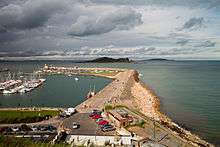
Howth
| Howth Binn Éadair | |
|---|---|
| Village and suburb | |
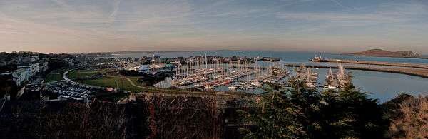
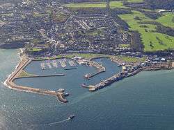 Aerial photo of Howth and harbour | |
 Howth Location in Dublin | |
| Coordinates: 53°23′10″N 6°03′58″W / 53.386°N 6.066°WCoordinates: 53°23′10″N 6°03′58″W / 53.386°N 6.066°W | |
| Country | Ireland |
| Province | Leinster |
| County | Dublin |
| Administrative County | Fingal |
| Highest elevation | 171 m (561 ft) |
| Lowest elevation | 0 m (0 ft) |
| Population (2016)[1] | |
| • Urban | 8,277 |
Howth (/ˈhoʊθ/ HOATH; Irish: Binn Éadair, meaning "Éadar's peak")[2][3] is a village and outer suburb of Dublin, Ireland. The district occupies the greater part of the peninsula of Howth Head, forming the northern boundary of Dublin Bay. Originally just a small fishing village, Howth with its surrounding once-rural district is now a busy suburb of Dublin, with a mix of suburban residential development, wild hillside and heathland, golf courses, cliff and coastal paths, a small quarry and a busy commercial fishing port. The only neighbouring district on land is Sutton. Howth is also home to one of the oldest occupied buildings in Ireland, Howth Castle. It has been the location for many films.
Howth is also a civil parish in the ancient barony of Coolock.[4]
Location and access
Howth is located on the peninsula of Howth Head, which begins around 13 kilometres (8.1 mi) east-north-east of Dublin, on the north side of Dublin Bay. The village itself is located 15 kilometres (9.3 mi) from Dublin city centre (the ninth of a series of eighteenth century milestones from the Dublin General Post Office (GPO) is in the village itself), and spans most of the northern part of Howth Head, which was once an island but now is connected to the rest of Dublin via a narrow strip of land (tombolo) at Sutton. Howth is located in the administrative county of Fingal.
Howth is at the end of a regional road (R105) from Dublin and is one of the two northern termini of the DART suburban rail system. Dublin Bus also serves Howth with route 31 and its variants.
History and etymology
The name Howth is thought to be of Norse origin, perhaps being derived from the Old Norse Hǫfuð ("head" in English). Norse vikings colonised the eastern shores of Ireland and built the settlement of Dublin as a strategic base between Scandinavia and the Mediterranean. Norse Vikings first invaded Howth in 819.
After Brian Ború, the High King of Ireland, defeated the Norse in 1014, many Norse fled to Howth to regroup and remained a force until their final defeat in Fingal in the middle of the 11th century. Howth still remained under the control of Irish and localized Norse forces until the invasion of Ireland by the Anglo-Normans in 1169.
Without the support of either the Irish or Scandinavian powers, Howth was isolated and fell to the Normans in 1177. One of the victorious Normans, Armoricus (or Almeric) Tristram, was granted much of the land between the village and Sutton. According to the historian Samuel Lewis:
In 1177, Sir Amorey Tristram and Sir John de Courcy landed here at the head of a large military force, and totally defeated the Danish inhabitants in a sanguinary battle at the bridge of Evora, over a mountain stream which falls into the sea near the Baily lighthouse. This victory secured to Sir Amorey the lordship of Howth, of which his descendants have continued in possession to the present day, under the name of St. Laurence, which Almaric, third baron, assumed in fulfilment of a vow previously to his victory over the Danes near Clontarf, in a battle fought on the festival of that saint. The territory of Howth was confirmed to Almaric de St. Laurence by King John....[5]
Tristam built his first castle near the harbour and the St. Lawrence link remains even today (see Earl of Howth). The original title of Baron of Howth was granted to Almeric St. Lawrence by Henry II of England in 1181, for one Knight's fee.
Howth was a trading port from at least the 14th century, with both health and duty collection officials supervising from Dublin, although the harbour was not built until the early 19th century.
A popular tale concerns the pirate Gráinne O'Malley, who was rebuffed in 1576 while attempting a courtesy visit to Howth Castle, home of the Earl of Howth. In retaliation, she abducted the Earl's grandson and heir, and as ransom she exacted a promise that unanticipated guests would never be turned away again. She also made the Earl promise that the gates of Deer Park (the Earl's demesne) would never be closed to the public again, and the gates are still open to this day, and an extra place is set for unexpected guests during formal dinners in the dining room.
In the early 19th century, Howth was chosen as the location for the harbour for the mail packet (postal service) ship. One of the arguments used against Howth by the advocates of Dún Laoghaire was that coaches might be raided in the badlands of Sutton! (at the time Sutton was open countryside.) However, due to silting, the harbour needed frequent dredging to accommodate the packet and eventually the service was relocated to Dún Laoghaire. George IV visited the harbour in August 1821.
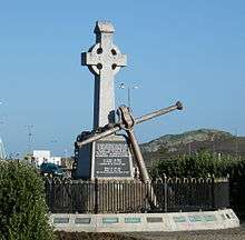
On the 26 July 1914, 900 rifles were landed at Howth by Erskine Childers for the Irish Volunteers. Many were used against the British in the Easter Rising and in the subsequent Anglo-Irish War. Among the members of the Howth branches of the Irish Volunteers and Cumann na mBan who participated in this event were the well-known writers Padraic Colum and Mary Colum. Members of both the Howth Volunteers and Baldoyle section of the Irish Citizen Army participated in the Easter Rising in Dublin city and in Fingal. A strong local branch of Sinn Féin developed in the area and there was considerable local involvement in both the Irish War of Independence and Irish Civil War.[6]
The harbour was radically rebuilt in the late 20th century, with distinct fishing and leisure areas formed, and the installation of a modern ice-making facility. A new lifeboat house was later constructed, and Howth is today home to both the RNLI (lifeboat service) and the Irish Coastguard.
Features
Howth Head is one of the dominant features of Dublin Bay, with a number of peaks, the highest of which is Black Linn. In one area, near Shielmartin, there is a small peat bog, the "Bog of the Frogs". The wilder parts of Howth can be accessed by a network of paths (many are rights of way) and much of the centre and east is protected as part of a Special Area of Conservation of 2.3 square kilometres (570 acres).
The peninsula has a number of small, fast-running streams, three of which run through the village, with more, including the Bloody Stream, in the adjacent Howth Demesne. The streams passing through the village are, from east to west, Coulcour Brook, Gray's Brook or the Boggeen Stream, and Offington Stream. Further cityward is the Whitewater Brook, with a tributary in a sunken area of plants and ponds.
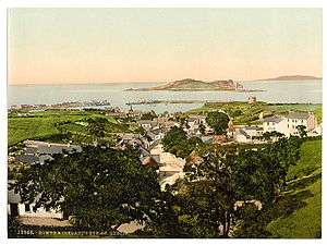
The island of Ireland's Eye, part of the Special Area of Conservation, lies about a kilometre north of Howth harbour, with Lambay Island some 5 km further to the north. A Martello tower exists on each of these islands with another tower overlooking Howth harbour (opened as a visitor centre and Ye Olde Hurdy Gurdy Museum of Vintage Radio on June 8, 2001[7]) and another tower at Red Rock, Sutton. These are part of a series of towers built around the coast of Ireland during the 19th century.
Built heritage
Howth Castle, and its estate, at least part of which is known as Deer Park, are key features of the area. On the grounds of Howth Castle lies a collapsed dolmen, known locally as Aideen's Grave.
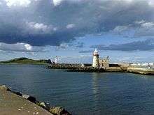
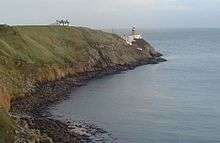
At the south-east corner of Howth Head, in the area known as Bail(e)y (historically, the Green Bayley) is the automated Baily Lighthouse, successor to previous safety mechanisms, at least as far back as the late 17th century.
In Howth village are St. Mary’s Church and its graveyard, overlooking the harbour. The earliest church on this site was built by Sitric, King of Dublin, in 1042. It was replaced around 1235 by a parish church, when that function was moved from the church on Ireland's Eye, and then, in the second, half of the 14th century, the present church was built. The building was modified in the 15th and 16th centuries, when the gables were raised, a bell-cote was built and a new porch and south door were added. The St. Lawrence family, of nearby Howth Castle, also modified the east end to act as a private chapel; inside is the tomb of Christopher St Lawrence, 2nd Baron Howth, who died in 1462, and his wife, Anna Plunkett of Ratoath.
Also of historic interest is The College, on Howth's Main Street.
Amenities and businesses
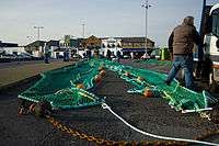
Howth remains an active centre of the fishing industry, with some processing performed in the fishing harbour area, and some boat maintenance. The village is also home to the Olympic Council of Ireland.
The area is active commercially, with a range of retail and leisure outlets, including multiple restaurants and a post office, although the nearest supermarket is at Sutton Cross and the nearest filling station in Bayside.
Howth, having once held at least five hotels, saw the last, the Deer Park Hotel, close in April 2014, although the premises continues to trade as a bar and base for the Deer Park golf courses with the recent addition of a 'FootGolf' course. The area has multiple bed-and-breakfast establishments. The nearest operational hotel (The Marine Hotel) is located at Sutton Cross, approximately 2.5 km from Howth harbour.
Howth forms part of the area of the Howth Sutton Baldoyle Chamber of Commerce.[8]
Recreation

Large numbers of tourists visit Howth annually in order to avail of the stunning views from the summit, to walk the piers, and to taste locally sourced seafood.[9]
Howth is a popular area for birdwatching and sailing, and is also popular with anglers. Anything from cod to ray can be caught from Howth's rocky shore marks. Sea mammals, such as seals, are common sights in and near the harbour. It used to be popular to feed the seals but authorities banned the practice for a variety of reasons.[10] Birds seen regularly include razorbill, guillemot, fulmar, kittiwake, stonechat, linnet, whitethroat, yellowhammer, skylark, wheatear, peregrine, buzzard and kestrel.
Howth is also a popular destination for cyclists, joggers and hill-walkers alike, particularly on weekends. One attraction is the 6 kilometer long Cliff Path Loop. The loop walk takes about two hours to complete and is rated with an easy to moderate difficulty. It begins and ends at the Howth DART [Railway] Station. Another popular walk is the original Cliff Walk all the way to Red Rock in Sutton.
Local government
Howth was within County Dublin from the introduction of the sheriff by the Normans, and within North Dublin rural district from its creation under the Local Government (Ireland) Act 1898. In 1918 Howth became a separate urban district with the consent of the Local Government Board for Ireland and despite the opposition of North Dublin rural district council.[11][12] In 1942, it was transferred to Dublin county borough, with Dublin Corporation superseding the urban district council.[12][13][14] In 1993, it was removed from the city and assigned to Fingal County Council, the successor north of the River Liffey to Dublin County Council.[12][15]
Popular culture
Howth has been a filming location for movies such as The Last of the High Kings, Boy Eats Girl and Sing Street.
Notable residents

Among Howth's better-known residents are or have been:
- William Butler Yeats spent some of his childhood in a small house above the cliffs on Balscadden Road in Howth
- Booker Prize-winning novelist John Banville
- U2 drummer Larry Mullen lives overlooking Burrow Beach
- Senator and retail pioneer Feargal Quinn and members of his family
- The late politician and writer Conor Cruise O'Brien and his wife, the Irish poet Máire Mhac an tSaoi lived here for many years
- Broadcaster Gay Byrne and his wife, author Kathleen Watkins, lived in the Baily region of Howth for decades, and later passed their home to one of the daughters
- Current European Ombudsman Emily O'Reilly also resides in Howth with her family of seven
- Actor Stuart Townsend, born and raised in Howth
- John Sheahan of The Dubliners
- Dolores O'Riordan (1971-2018) of The Cranberries
- Johnny Logan (singer) winner of the Eurovision multiple times, lived here for many years, along with his father, tenor Patrick O'Hagan
- John McColgan and wife Moya Doherty, founders of Riverdance, have been resident in Howth for many years
- Broadcaster Seán Moncrieff lives in Howth with his family
- Saoirse Ronan, actress, moved from Carlow to Howth with her family, and later bought a house in the Thormanby part of Howth[16]
- Phil Lynott of Thin Lizzy lived in Howth for a time.[17]
- Actor and producer Brendan Gleeson moved to the Baily region of Howth
- Writer Michael Feeney Callan
- Sculptor Patrick O'Reilly
- Barney McKenna (up until his passing April 5, 2012)
- Composer Ciarán Farrell
- Lynn Redgrave and husband John Clark raised their family there in the early 1970s
- Bill Graham, journalist & author lived in Howth until his death in 1996
- Scott Young who was a Canadian journalist, sportswriter, novelist, and the father of musicians Neil Young and Astrid Young, lived in Howth in the late 1980s
- Composer Brian Boydell was born in Howth in 1917
- Actor writer and comedian Gary Cooke lived on the Claremont Road Howth in the 1970s and 1980s
- The eminent judge Gerald FitzGibbon lived here for many years until his death in 1909: his house, Kilrock, was one of the centres of Dublin social life from the 1870s onwards
Transport
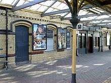
- Howth railway station opened on 30 May 1847,[18] is a two-platform terminal station served by the Dublin Area Rapid Transit.
- The Hill of Howth Tramway ran around the peninsula between Howth station, the summit and Sutton station until 1959.
- Small boats run to Ireland's Eye in the summer months. The boats are located at the end of the pier. Ireland's Eye is used and has a reputation as a spot for birdwatching.
- Dublin Bus runs the 31 service to Howth Summit via Howth village and the 31B services the more remote side of the peninsula. The 31B also terminates in Howth Summit, however it does not pass Howth village. The new 31A bus route, which started taking effect in 2013, takes an almost identical route to the 31, however does not stop at Howth Summit, but continues on to Shielmartin Road.
- Howth is also home to the National Transport Museum of Ireland which houses public service and road transport vehicles.[19]
See also
References and sources
- Notes
- ↑ "Census 2006 – Volume 1 – Population Classified by Area" (PDF). Central Statistics Office Census 2006 Reports. Central Statistics Office Ireland. April 2007. Archived from the original (PDF) on 2011-06-07. Retrieved 2011-06-08.
- ↑ Dublin, Ireland, 1975; Houses of the Oireachtas: The Placenames Order (Irish forms) (No. 1) (Post towns) / An tOrdú Logainmneacha (Foirmeacha Gaeilge) (Uimh. 1) (Postbhailte)
- ↑ "Howth". Encyclopedia.com. Retrieved 6 July 2012. This webpage cites: A.D. Mills (2003) A Dictionary of British Place-Names, Oxford University Press.
- ↑ Placenames Database of Ireland - Howth civil parish
- ↑ Samuel Lewis, A Topographical Dictionary of Ireland, Volume 2, p. 10, S. Lewis & Co., London (1837)
- ↑ O'Connor, Philip (2016). Road to Independence: Howth, Sutton and Badoyle Play Their Part. Dublin: Howth Free Press. p. 310. ISBN 978-0955316333.
- ↑ http://homepage.eircom.net/~HowthSuttonLions/environment.htm
- ↑ Howth Sutton Baldoyle Chamber of Commerce
- ↑ "Top 3 reasons to visit Howth - Dublin Visitors Centre". Dublin Visitors Centre. 2014-11-11. Retrieved 2016-11-23.
- ↑ "Howth - Ireland". Ireland. Retrieved 2016-12-01.
- ↑ Local Government Board for Ireland. "Local Government (Ireland) Acts". Annual report for the year 1916-17. Command papers. Cmd.8765. p. 17.
- 1 2 3 Department of the Environment, Heritage & Local Government (8 May 2008). "Annex III - Some Notes on Town Government". A Green Paper on Local Government. Archived from the original on 13 October 2014. Retrieved 4 December 2014.
- ↑ "Local Government (Dublin) (Amendment) Act, 1940". Irish Statute Book. Retrieved 4 December 2014.
- ↑ "S.I. No. 372/1942 - Local Government (Dublin) (Amendment) Act, 1940 (Appointed Day) Order, 1942". Irish Statute Book. Retrieved 4 December 2014.
- ↑ "Local Government (Dublin) Act, 1993". Irish Statute Book. Retrieved 4 December 2014.
- ↑ https://www.independent.ie/woman/celeb-news/teen-star-saoirse-forks-out-334k-for-howth-home-29582647.html
- ↑ He is buried in St Fintan's Cemetery on the Sutton side of Howth Head, which is also the burial place of Charles Haughey, thrice Taoiseach of Ireland
- ↑ "Howth station" (PDF). Railscot — Irish Railways. Retrieved 2007-09-03.
- ↑ http://www.nationaltransportmuseum.org/about.html
- Sources
- Dublin, 1920: Joyce, Weston St. The Neighbourhood of Dublin
- Road to Independence: Howth, Sutton and Baldoyle Play Their Part, by Philip O’Connor, Howth Free Press, 312 pp, ISBN 978-0955316333. For a review of this book see http://www.drb.ie/essays/the-view-from-the-hill
- Dublin: Howth, a Guide and Map; Dublin County Council, nd (1980's?)
- ^ By Swerve of Shore, Michael Fewer, (2002), ISBN 0-7171-3353-2, an account of the author's walk along the coast of County Dublin
External links
| Wikivoyage has a travel guide for Howth. |
| Wikimedia Commons has media related to Howth. |
- Howth Sutton Baldoyle Chamber of Commerce
- Howth is Magic - local tourism website
- Google Maps—map of the Howth peninsula
- East Pier Martello tower
- Interview with Diarmuid Ó Cathsaigh of the Howth Peninsula Heritage Society Radio Documentary from Near90fm
- Pictures of Howth
- Howth Coast Guard Unit Voluntary Coastal & Cliff Rescue Unit
- Classic Photos of Howth
- Howth Lifeboat Station
- "A Modern Depiction of Ireland, One of the British Isles" 1598 by Abraham Ortelius