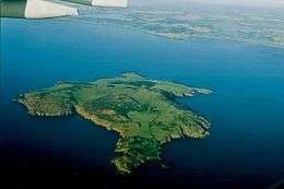
Lambay Island
| Native name: Reachrainn | |
|---|---|
 | |
 Lambay | |
| Geography | |
| Location | Irish Sea |
| Coordinates | 53°29′39″N 5°59′44″W / 53.494147°N 5.995671°WCoordinates: 53°29′39″N 5°59′44″W / 53.494147°N 5.995671°W |
| Area | 2.5 km2 (0.97 sq mi) |
| Length | 2.7 km (1.68 mi) |
| Width | 2.2 km (1.37 mi) |
| Coastline | 10 km (6 mi) |
| Highest elevation | 127 m (417 ft) |
| Highest point | Knockbane |
| Administration | |
| Province | Leinster |
| County | Dublin |
| Electoral division | Donabate |
| Demographics | |
| Population | 7 (2017) |
| Pop. density | 2.4 /km2 (6.2 /sq mi) |
| Ethnic groups | Irish |
Lambay, sometimes referred to as Lambay Island (from Old Norse Lambey, meaning 'lamb island'; called in Irish: Reachrainn)[1] lies in the Irish Sea off the coast of north County Dublin in Ireland. It is four kilometres (2 mi) offshore from the headland at Portrane and is the easternmost point of the province of Leinster.
Similarly named places are Lamba in the Faroe Islands and Lamba in Shetland.
History
Ptolemy's Geography (2nd century AD) described an island called Εδρου (Edrou). PIE *sed- ‘to sit, settle’ had descendants in many languages, including Greek ἑδρα (hedra) ‘sitting place’ whose many specific uses included ‘base for ships’.[2]
Physical description
Lambay Island is the largest island off the east coast of Ireland and is about 2.5 square kilometres (240 hectares or 593.1 acres) in size. Its highest point rises to 127 metres (416.7 feet). There are steep cliffs on the northern, eastern, and southern sides of the island, with a more low-lying western shore. The geology is dominated by igneous rocks, with shales and limestones. There are a small number of wells and streams.
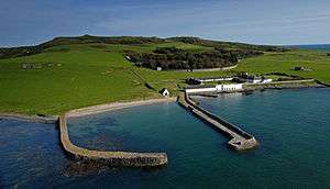
There is a private harbour on the western shore, and there are a small number of buildings nearby including a bothy, coastguard cottages and a real tennis court.
Lambay Castle

A small late 16th-century fort with battlemented gables, possibly incorporating a 15th-century blockhouse, on the island was transformed by Sir Edwin Lutyens into a romantic castle for the Hon. Cecil Baring, afterwards 3rd Lord Revelstoke. Baring had been working in the USA when he fell in love with the wife of one of his co-directors. She divorced her husband and married Baring. He bought the island for £5,250 in 1904 as a place to escape to with his beautiful young wife, Maude Louise Lorillard, the daughter of Pierre Lorillard, the first American to win The Derby. The story of their early life on the island inspired Julian Slade’s musical Free as Air.
Lutyens made the old fort habitable and built a quadrangle of kitchens, bathrooms and extra bedrooms adjoining it, with roofs of grey Dutch pantiles sweeping down almost to the ground. He also built a circular curtain wall or enceinte surrounding the castle and its garden, with an impressive bastioned gateway; this wall serves the practical purpose of a wind break, enabling trees and plants to grow inside it – which would not grow outside. Everything is of a silvery grey stone. The rooms in the castle have vaulted ceilings and stone fireplaces; there is a stone staircase with many curves and an underground gallery in the new quadrangle which might have been conceived by Piranesi. According to the Revelstoke records on the island, Lambay Castle is also the location where Michael Powell wrote his screenplay for Black Narcissus (1947).
Lutyens also designed the approach from the harbour, with curved step-like terraces reminiscent of the now-vanished Ripetta in Rome and a series of ellipses, circles being a long-standing symbol of welcome and also of wholeness. Characteristically, having ascended those Baroque steps, one has to cross an open field to come to the curtain wall, the entrance gateway not being at first visible; so there is a sense of expectancy.
Close to the harbour is the White House, a largely horse-shoe shaped house with high roofs and whitewashed walls, which Lutyens designed in the 1930s for Lord Revelstoke's daughters Daphne and Calypso and their families, while the castle and island were left to his only son Rupert Baring. On a small cliff-top near the White House is an old Catholic chapel, with a portico of tapering stone columns (also added by Lutyens) and a barrel vaulted ceiling. Inside are various religious symbols and artefacts made by members of the family, including the little stain-glass window.
Wildlife
The island supports one of the largest and most important seabird colonies in Ireland, with over 50,000 common guillemots, 5,000 kittiwakes, 3,500 razorbills, 2,500 pairs of herring gulls, as well as smaller numbers of puffins, Manx shearwaters, fulmars, greylag geese and many other species.
Among the mammals of the island are Atlantic Great grey seals (Ireland's only east coast colony ), which pup on the island itself; wild red-necked wallabies (introduced by Rupert Baring in the 1950s, augmented by a surplus from Dublin Zoo in the 1980s, numbering perhaps around 100 in 2017),[3][4][5] and introduced fallow deer (a herd of about 200). There is also a herd of farmed cattle on the island. Rockabill and Lambay islands are the best places in County Dublin to see harbour porpoises.[6]
Current status

The island is still privately owned by the Baring family trust. The medieval castle is the only Lutyens-designed home, together with the Liria Palace in Madrid, which is still in the occupation and ownership of the original family that commissioned it. Alex Baring (7th Baron Revelstoke) is currently in occupation. The farm has accepted WWOOFers as volunteers in the past.[7] The estate includes domestic extensions to the old Castle, a row of Coastguard cottages, the Bothy, the White House (family guesthouse), a harbour and boathouse and a distinctive open-air real tennis court, the only one remaining in Ireland (there was one in the old University College Dublin complex on Earlsfort Terrace). There is also the farm with cottages, and the Chapel is located on an isolated promontory. All architecture was either designed or renovated by Sir Edwin Lutyens.
Due to its deep surrounding waters, the island attracts scuba divers and fishermen, as well as lobster-potters. The island is accessible by invitation only, mainly from Malahide Marina and occasionally Rogerstown Pier, Rush and Skerries Harbour all north of Dublin.
Prehistory and history
The island was important in the Neolithic period in Ireland as a ground stone axe quarrying and production site. Two outcrops of andesite, or Lambay porphyry as it is more commonly known, were utilised. The quarry site is unusual in Ireland for being the only Neolithic stone axe quarry with evidence for all stages of production, from quarrying to final polishing.
The ancient Roman writer Pliny and the ancient Greek Ptolemy knew about the island and referred to it as Limnus or Limni. Its Irish name, Reachra, was eventually joined by a Norse name based on the root word ey for island. The name Lambey probably originated with the practice of sending over ewes to the island in spring to lamb in a predator-free environment. The belief that the fore part of the name in Norse is from the word lamb makes perfect sense, but may be a later rationalisation for a name based on whatever the name of the island was at the time of Pliny and Ptolemy and the word ey. The Irish name for the nearby coastal area of Portrane, Port Reachrainn, originated from its position facing the island.
A number of Iron Age burials were discovered on the island in 1927 during works on the island's harbour. The finds included a number of Romano-British items, and the site has been interpreted as evidence for the arrival of a small group of refugees from Brigantia, fleeing the Romans from 71 to 74.
St. Columba is said to have established a monastic settlement on Lambay c. 530 AD, and Ireland's Viking age began with a raid on this settlement. The raid, marked by the pillaging of the island's church and the burning of its buildings, took place in 795. (The burning of Reachrainn by plunderers; and its shrines were broken and plundered.) Surveying in the 20th century found remains of an enclosure to the south of the present chapel, and suggestions of a connected moated site (the present chapel was renovated by Sir Edwin Lutyens in the early 20th century).
Sitric, a Danish King of Dublin, granted Lambay to Christ Church Cathedral, and in 1181 Prince John granted it to the Archbishops of Dublin. This was reconfirmed by King Edward in 1337 and by King Richard in 1394. A later archbishop gave the rents of the island to the nuns of Grace Dieu for the upkeep of their monastery and school. He also gave the tithes of the Lambay rabbits to the nuns and at that time the rabbit taxes were worth 100 shillings a year.
In 1467, it was provided by statute that the Earl of Worcester, then Lord Deputy, be granted Lambay to build a fortress for England's protection against the Spaniards, French and Scots. Worcester paid the Archbishop of Dublin 40 shillings per annum and though he had a licence to build a castle on Lambay it is not certain that it was actually built.
During the reformation, Archbishop Brown granted the Island to John Challoner for a rent of £6.13.4. The conditions were that Challoner would within six years build a village, castle and harbour for the benefit of fishermen and as a protection against smugglers. He was to inhabit Lambay "with a colony of honest men". He was a very active man who worked four mines for silver and copper and bred falcons on the island's many cliffs.
Challoner still owned Lambay in Elizabethan times but in 1611 the island was granted to Sir William Ussher and his heirs. James Ussher, later the Anglican Archbishop of Armagh, lived on Lambay in 1626 but by 1650 he was resident in London. He was highly respected by Cromwell and today lies buried in Westminster Abbey. The Ussher family held the island for 200 years. In the 17th century there was some exploratory lead or copper mining.
During the Williamite war in Ireland, the island was used as an internment camp for Irish soldiers. More than one thousand of them were imprisoned there after the Battle of Aughrim in 1691 and some died of wounds and starvation.
In 1805, the leasehold of Lambay was inherited by Sir William Wolseley, and in 1814 it was acquired by the Talbot family of Malahide. In 1860 the existing farmers were removed and replaced with English and Scottish tenants.
Having sold nearby Portrane House, Count James Consedine bought Lambay in 1888, developing the island for hunting. In turn, the Baring family of banking fame bought Lambay Island in 1904 for £5,250 pounds (depending on different sources). Cecil Baring hired Sir Edwin Lutyens to work on renovation of the island's main residence, the 15th Century fort, and surrounds. Lutyens became a firm friend of the island and continued to return there throughout his life, adding to his architectural designs and renovations over the course of 30 years or so. Cecil Baring became Lord Revelstoke in 1929 and died in 1934. He and his beloved wife Maude Lorillard are buried in the family Mausoleum on Lambay, along with their son Rupert Baring and grandsons John and James Baring. The Mausoleum, also designed by Lutyens, forms part of the circular rampart wall around the Castle and is engraved with a poem Cecil wrote in memory of Maude when she died.
The island has claimed a number of shipwrecks, one of the most notable of which was RMS Tayleur. One of the largest merchant ships of her day, she struck the island on 21 January 1854 just hours into her maiden voyage from Liverpool to Perth, Australia and sank with the loss of 380 lives.[8]
Lambay was the landing site of the winners of the 1921 Gordon Bennett Gas Balloon Race. The pilots were Captains Armbruster and Ansermier, both Swiss. They took off from Brussels, Belgium, and flew 756 kilometres with a maximum altitude of 3,600 metres during their flight of 27 hours and 23 minutes.
Lambay Island was Protestant majority until the early 20th century.
Demographics
The table below reports data on Lambay's population taken from Discover the Islands of Ireland (Alex Ritsema, Collins Press, 1999) and the Census of Ireland. Census data in Ireland before 1841 are not considered complete and/or reliable.
| Historical population | |||||||||||||||||||||||||||||||||||||||||||||||||||||||||||||||||||||||||||||||||||||
|---|---|---|---|---|---|---|---|---|---|---|---|---|---|---|---|---|---|---|---|---|---|---|---|---|---|---|---|---|---|---|---|---|---|---|---|---|---|---|---|---|---|---|---|---|---|---|---|---|---|---|---|---|---|---|---|---|---|---|---|---|---|---|---|---|---|---|---|---|---|---|---|---|---|---|---|---|---|---|---|---|---|---|---|---|---|
|
| ||||||||||||||||||||||||||||||||||||||||||||||||||||||||||||||||||||||||||||||||||||
| Source: John Chambers. "Islands - Change in Population 1841 - 2011". irishislands.info. Retrieved March 25, 2015. | |||||||||||||||||||||||||||||||||||||||||||||||||||||||||||||||||||||||||||||||||||||
See also
References
- Cooney, G. (1993). "Lambay: an island on the horizon." Archaeology Ireland, 7 (4), 24–8.
- MacAlister, R. A. S. (1929). "On some antiquities discovered upon Lambay island." Proceedings of the royal Irish Academy, 38c, 240–246.
- Merne, O. J. & Madden, B. (1999). "Breeding seabirds of Lambay, County Dublin." Irish Birds, 6, 345–358.
- Rynne, E. (1976) "The La Tène and Roman Finds from Lambay, Co. Dublin: a re-assessment." Proceedings of the royal Irish Academy, 76c, 231–44.
- Stillman, C. (1994) "Lambay, an ancient volcanic island in Ireland." Geology Today, 62, 62–67.
- Denniston, George "James Gordon Bennett Coupe (Cup) Gas Balloon Races; Chapter 10 // http://gasballooning.net
References
- ↑ Lambay Island Placenames Database of Ireland. Retrieved: 23 March 2012.
- ↑ http://www.romaneranames.uk/essays/ireland.pdf
- ↑ "What the Heck Are Wallabies Doing in Ireland?". Smithsonion. 12 November 2014. Retrieved 21 February 2015.
- ↑ "Archaeological Wallabies on Lambay Island". Seandálaíocht - Irish for Archaeology. 8 July 2010. Retrieved 21 February 2015.
- ↑ http://www.thejournal.ie/wallabies-lambay-island-2-3516673-Jul2017
- ↑ Hoyt, Erich. "The Best Whale Watching in Europe" (PDF). The Best Whale Watching in Europe A guide to seeing whales, dolphins and porpoises in all European waters by Erich Hoyt WDCS, the Whale and Dolphin Conservation Society.
- ↑ "WOOFing in Leinster".
- ↑ Guy, Stephen (2010). "Wreck of the Tayleur". National Museums Liverpool Blog.
External links
| Wikimedia Commons has media related to Lambay Island. |