Castleknock
| Castleknock Caisleán Cnucha | |
|---|---|
| Suburb (village core) | |
 St Brigid's church, Castleknock (Church of Ireland) | |
 Castleknock Location in Ireland | |
| Coordinates: 53°22′26″N 6°21′32″W / 53.374°N 6.359°WCoordinates: 53°22′26″N 6°21′32″W / 53.374°N 6.359°W | |
| Country |
|
| Province | Leinster |
| County | Fingal |
| Council | Fingal County Council |
| Dáil Éireann | Dublin West |
| EU Parliament | Dublin |
| Elevation | 63 m (207 ft) |
| Population (2006)[1] | |
| • Urban | 21,457 |
| Postal district(s) | Dublin 15 |
| Dialing code | 01, +353 1 |
| Irish Grid Reference | O078378 |
Castleknock (Irish: Caisleán Cnucha, meaning "Cnucha's Castle"[2]) is a suburb of Dublin, centred on a village, in Fingal, Ireland. It is located 8 km (5 mi) west[3] of the centre of Dublin. Castleknock is the village in which the established independent school Castleknock College is situated.
Castleknock is also the name of a large civil parish.
Location and access


The village is located just inside the city's M50 motorway ring road, bordered to the west by the large suburb of Blanchardstown, to the east by the Phoenix Park, to the north by Dunsink and to the south by the village of Chapelizod above the Liffey valley. Most of Castleknock lies within the M50 but a portion lies on the western side of the motorway. The R147 Navan Road also serves the area. The Royal Canal and the Dublin-Sligo railway line pass through the area from east to west.
The village of Castleknock is in the Dublin 15 postal area.
Rail connections
September 2012
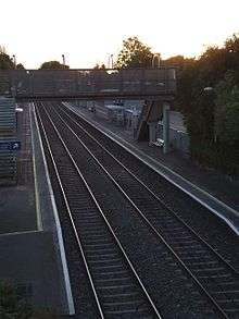
The Dublin Suburban Rail the Western Suburban Railway Line or Maynooth Line running from Dublin Connolly to Maynooth. Castleknock railway station opened on 2 July 1990.[4]
Plans
As part of the government's "Transport 21" strategy, a Metro line was planned, from the southern suburb of Tallaght, through the neighbourhood of Castleknock, to Dublin Airport. Quoting from the plans:
"The path of the Metro will first swing into Dublin 15 at the south end of Castleknock golf course and proceed past Porterstown playing pitches where it is hoped to have “minimal impact.” The stop at Porterstown will be directly above the current Maynooth train line allowing the potential in the future to integrate the two services. Another stop will be provided at the Millennium Park with the line going around the park’s perimeter rather than cutting through it as had originally been envisaged. It will then proceed around by McDonalds before its major stop in Dublin 15 adjacent to Draíocht, the Civic Offices, and the shopping centre. Its path will then continue around the Westend side of the shopping centre, past Westpoint where it will cross the Navan Road and go up the Snugborough Road."[5]
Buses
Public transport in Castleknock is provided by Dublin Bus routes 37 and 38. The 37 bus runs from Blanchardstown Town Centre to Wilton Terrace, Baggot Street. Also, The 38 bus runs from Burlington Rd. Towards Damastown and vice versa.
History
Mythic Milesian period
"During the Milesian era Castleknock is named as one of twenty-five places at which Conmhaol of the race of Eber, while holding the sovereignty of Ireland, defeated in battle the descendants of Eremon,' and a Celtic writer mentions that Castleknock was sometimes known as duma meic Eremon, or the duma of the sons of Eremon.' The mention of a duma shows that there was at a very early time an eminence of note at Castleknock ; the duma may have been, Mr. Westropp observes, used for purposes of residence, sepulchre, or outlook, or, as in the case of Duma Selga, for all three."
In a poem relating to the earliest centuries after Christ the origin of the name Cnucha is connected with Conn of the Hundred Battles, and the name is said to have been borne by his foster-mother: —
- The nurse of Conn who loved this strip of land
- Was Cnucha of the comely head;
- She dwelt on the dun with him
- In the reign of Conn of the Hundred Fights.
- Cnucha, the daughter of Concadh Cas,
- From the land of Luimncach broad and green,
- Died yonder in that house
- To the horror of the Gaels.
- The woman was buried, a grief it was.
- In the very middle of the hill ;
- So that from that on Cnucha
- Is its name until the judgment.[6]
Feudal period
The Barony of Castleknock was originally a feudal lordship created in the 12th century for the Tyrell family; it passed by inheritance to the Burnell family. The first Baron, Hugh Tyrrel, gave lands in the barony at Kilmainham to the Knights of St. John who continue in the area today in the form of St. John Ambulance. Later, civil parishes, based on the boundaries of the Ecclesiastical parishes of the Established church were used to sub-divide the barony. This table[7] lists the nine civil parishes of the barony.
| Name in Irish | Name in English |
|---|---|
| An Barda | Ward |
| Caisleán Cnucha | Castleknock |
| Clochrán | Cloghran |
| Cluain Saileach | Clonsilla |
| Fionnghlas | Finglas |
| Mullach Eadrad | Mulhuddart |
| Paróiste San Iúd | St. Jude's |
| Paróiste San Séamas | St. James's |
| Séipéal Iosóid | Chapelizod |
Note 1: the entire barony lies north of the River Liffey. The parish of St Jude's,[8] which consists of six townlands, is situated on both banks of the Liffey. The only part of the parish that lies to the north of the Liffey is a field of 499 acres in the south-eastern corner of the Phoenix Park as well as a thin strip of 49 acres between the Chapelizod road and the river - the townland of Longmeadows. According to the 6 inch historical maps from the Ordnance Survey of Ireland that were created in 1829, no such parish exists. Only the later map of 1889, at a scale of 25 inches, displays the parish.
Civil parish
Within the civil parish of Castleknock, there are 22 townlands per the table below.[7] Like all civil parishes in Ireland, this civil parish is derived from, and co-extensive with, a pre-existing parish of the Church of Ireland. In 1773, an act of council united the parish with the curacies of Clonsilla and Mulhuddart. In 1837, Lewis' directory reported that the living (of the ecclesiastical parish) was a vicarage in the diocese of Dublin which was: "... endowed with a portion of the great tithes, and united to the prebend of Castleknock and the rectory of Clonsillagh and curacy of Mullahidart, with cure of souls: it is in the patronage of the Bishop.".[9] The two churches noted by Lewis in the vicarial union, one at Castleknock, the other at Clonsilla, are extant and in use by the Church of Ireland community. The former was rebuilt by a loan of £1000 from the Board of First Fruits and large subscriptions, in 1810. In 1831, the population of the parish, including Blanchardstown was 4251 people of which 3409 were Catholic.[10]
The core of the parish is centred on the townland and village of the same name. The townland at the northern extremity is Huntstown, not to be confused with Huntstown and Littlepace in the neighbouring parish of Clonsilla; to south it is bounded by the River Liffey and the Phoenix Park; to the west it is bounded by Coolmine railway station and Blanchardstown Shopping Centre; to the east lies the 8th lock of the Royal Canal and the Cabra Gate of the Phoenix Park.
For convenience, the table below groups the parish's townlands by their location in one of the modern local authority areas. Some townlands, however, straddle both areas.
| Modern Local Authority Area |
Name in Gaelic | Name in English | Acres |
|---|---|---|---|
| Dublin City | Baile an Ásaigh | Ashtown (partly) | 278 |
| Baile Pheiléid | Pelletstown | 259 | |
| An Chabrach | Cabra | 457 | |
| Caisleán Cnucha (cuid de Pháirc an Fhionnuisce) | Castleknock (part of Phoenix Park) (partly) |
1020 (787) | |
| Fingal | Baile an Aba | Abbotstown[4 1] | 101 |
| Baile an Ásaigh | Ashtown (partly)[4 2] | 278 | |
| Baile an Chairpintéaraigh | Carpenterstown[4 3] | 166 | |
| Baile an Déanaigh | Deanestown[4 4] | 173 | |
| Baile an Diosualaigh | Diswellstown[4 5] | 418 | |
| Baile an Huntaigh | Huntstown[4 6] | 299 | |
| Baile an Phóirtéaraigh | Porterstown[4 7] | 219 | |
| Baile Bhlainséir | Blanchardstown[4 8] | 454 | |
| Baile Mhistéil | Mitchelstown[4 9] | 154 | |
| Baile Scriobail | Scribblestown[4 10] | 272 | |
| Baile Sheáin | Johnstown[4 11] | 67 | |
| An Chabrach | Cabra | 457 | |
| Caisleán Cnucha (cuid de Pháirc an Fhionnuisce) | Castleknock (part of Phoenix Park) (partly) |
1020 (787) | |
| Ceapach | Cappoge or Cappagh | 698 | |
| Cnoc na gCaorach | Sheephill | 349 | |
| An Chorr Dhubh | Corduff | 353 | |
| Dún Sinche | Dunsink | 423 | |
| Páirc Anna | Annfield | 19 | |
| Snugborough | Snugborough | 53 | |
| Steach Gob | Astagob | 93 | |
20th and 21st centuries
Castleknock was a rural village in western County Dublin until the late 1960s, when the first housing estates began to be developed. Castleknock developed in tandem with neighbouring settlement Blanchardstown, both of which grew rapidly from the early 1970s to the present. During the 1970s and 1980s, the village became subsumed into the suburban fabric of Dublin.
Planning controversies
Local representatives have criticised developments which they say are to the detriment of the local character and integrity of the village.[11]
In February 2010, there were concerns about the fate of the old post office when hoarding was erected around the site. However, "proposed work involves a high quality restoration of the building to its former state after many years during which it has remained vacant."[12]
Castleknock today
Features
- Castleknock Castle is located in the grounds of Castleknock College.
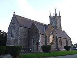
- The Abbey of St. Brigid (or Bridget) was founded in A.D. 1184 by the second Baron of Castleknock, Richard Tyrell, and was run by the Augustinian Canons Regular. Following the English Reformation and the dissolution of the monasteries under Henry VIII of England, the Abbey was destroyed and in 1609 a church was built on the site for the use of the Church of Ireland. The foundation stone of the church, which is in use today, still on the site of the Abbey, was laid in 1803.[13] The spire was added in 1864 by friends of the late James Hans Hamilton as a memorial to the MP.
- In the neighbouring townland of Diswellstown there is a historic "rag well" - a holy well near which rags were left. Although it still flows, it was "buried" by the County Council, and its site is now marked by a carved flagstone. Nearby the Diswellstown Stream, which rises near Castleknock village, flows west and then turns sharply south, taking in a streamlet from Carpenterstown, before running down to the Liffey in a narrow steep valley.
- Farmleigh- an estate of 78 acres (32 ha) situated to the north-west of Dublin's Phoenix Park. The Government bought the estate from the Guinness family for €29.2 million in 1999 and spent €23 million refurbishing it.[14] Quoting from the article: "One of the main reasons cited by the Government for buying the former Guinness estate was that it would be an official State guest house for visiting heads of State and dignitaries. However, it "was used to accommodate only two visiting dignitaries last year". In the interests of balance, the article goes on to say that "While the house has not been inundated with foreign dignitaries, it has proved popular with the public. Some 245,937 members of the public visited Farmleigh last year".
Amenities and businesses
Retail outlets
In the village proper may be found the Castleknock Village Centre, Castlecourt Shopping Centre and Ashleigh Centre shopping precincts which contain a variety of small local businesses and restaurants. The Post Office is located in the Castlecourt Shopping Centre (having previously been in the Castleknock Village Centre for many years). Shops such as Spar and an off licence are situated here.
The original Post Office was located directly opposite the church in a row of about 6 semi-detached styled houses. This is where the P&T would collect all the post from. There was a small sorting office out the back with some mail bags being left in the shed when the PO was shut.
Health care
There are three public health centres that serve Castleknock and, more generally, the Dublin 15 area, located at Riverside, Corduff and Roselawn.
State bodies
The National Food Centre is in Castleknock.
Education
Primary schools
- Castleknock National School (Church of Ireland) mixed
- St. Brigid's National School (Roman Catholic Church) mixed
- Castleknock Educate Together National School (non-denominational), located beside the Castleknock Tennis Club mixed
- Scoil Thomais (Saint Thomas' School in English) (Roman Catholic Church), located at the corner of "Castleknock Vale" and "Castleknock Rise". mixed
- St Patrick's National School,[15] Diswellstown Road, Castleknock, Dublin 15.mixed
Secondary Schools

- Castleknock College for boys, run by the priests of the Vincentian Order (Roman Catholic Church) since 1835, which was exclusively a boarding school until 1987, following which "day" pupils were admitted. It is now "day-only", as the boarding house was closed down in 2006. The campus is located beside the Farmleigh Estate and contains nine rugby pitches, a soccer pitch, a cricket crease with pavilion, an athletics and running track, six tennis courts and stables all set in landscaped gardens.
- Castleknock Community College, serving both boys and girls, is located in Diswellstown (a townland in the civil parish of Castleknock). Opened on 30 August 1995 as temporary accommodation for Hartstown Community School. In June 2013 the Department of Education and Skills approved the colleges new extension plan.The school has a population of 1100 students.
- Mount Sackville School for girls, run by the Sisters of St. Joseph of Cluny (Roman Catholic Church) since 1864. Although located in the townland of Knockmaroon and close to the village of Chapelizod, the school is within the boundary of the Fingal County.[16] Mount Sackville is a fee-paying school with a student population of over 630 pupils.
Sports and community groups
Sport
- The largest tennis facility in Ireland, which was home to tennis for the 2004 Special Olympics.
- Gaelic games are played at Castleknock Hurling and Football Club whose new 23-acre (93,000 m2) "Castleknock Community Park" will be the club's home.[17] Founded in 1998, Castleknock GAA Club has over 1500 members from over 650 families.
- St. Brigid's GAA Club play in Dr. Tom Russell Park (Old Navan Road, Castleknock) and is one of the largest clubs in the country. The club has five adult teams, including two senior teams and an intermediate team. Russell Park also boasts the largest all-weather pitch in Ireland.[18]
 Castleknock Golf Club
 - Golf clubs: Castleknock Golf Club, located 1 mile west of the village beside Castleknock Hotel; Luttrellstown Golf Club, located 2 miles west of the village; Municipal course located at Elm Green, about 1 mile south east of the village beside Dunsink.
- Soccer clubs: St.Mochta's FC with over 400 playing members and Castleknock Celtic FC has over 600 playing members.
- Rugby Union is played at Coolmine RFC.
Community groups
- Local First Aid Training, Event Cover and Community Care in the Castleknock Area is provided by St. John Ambulance Castleknock Combined Division and the Order of Malta Castleknock [19]
- There are a number of residents associations such as "Riverwood Residents Association" and "Carpenterstown Park Residents Association".[20]
- There is an active Tidy Towns Committee.
- Castleknock Community Centre,[21] in the Laurel Lodge area, hosts a range of social, sporting and charitable groups.
- Castleknock Scout Group, the 175th Castleknock, Dublin Troop, operate in this area and the Laurel Lodge/Carpenterstown areas.
Religious institutions
St. Brigid is the patron saint of the village.

Laurel Lodge / Carpenterstown

Catholic church in Castleknock.
In the feudal period mentioned above, the civil parish was coterminous with the ecclesiastical parish. Following the changes of the Reformation, the effect of the Penal Laws and population changes, this is no longer the case. In the Roman Catholic Church, there are today six parishes that serve the same area: St.Mochta's Parish, Blanchardstown parish,[22] Castleknock parish,[23] Corduff parish, Laurel Lodge parish[24] and Navan Road parish. Merger, not sub-division, has been the practice of the Church of Ireland, both in Castleknock and nationally, due to dwindling numbers of adherents. This has resulted in the merger of three civil parishes to form the United Parishes of Castleknock and Mulhuddart with Clonsilla[25]
The list below groups the churches by congregation in the parish[26]
- Roman Catholic
- St Philip, the Apostle (Mountview)
- The Oratory (Blanchardstown)
- Sacred Heart of Jesus (Huntstown)
- Mary, Mother of Hope, chapel of ease (Littlepace)
- Our Lady, Mother of the Church (Castleknock)
- St Mochta's (Porterstown)
- St Thomas, the Apostle parish, Laurel Lodge
- St Brigid's (Blanchardstown)
- St Ciaran's (Hartstown)[27]
- St Patrick's (Corduff)
- St Mary of the Servants (Blakestown)
- Our Lady Help of Christians (Navan Road)
- Church of Ireland
- St Brigid's (Castleknock)
- St Mary's (Clonsilla)
- St Thomas's (Mulhuddart)
- Protestant - other
- Christ Faith Tabernacle (Rosemount)
- Dublin West Community Church (Blanchardstown)
- Acting Faith Ministries (Coolmine)
- Baptist (Riversdale)
- Methodist (Tyrellstown)
- Cherubim & Seraphim Prince of Peace (Rosemount)
- New Covenant church (Ballycoolin)
- Open Door Christian Fellowship (Blanchardstown)
- General Foundation Apostolic Church in Christ (Mulhuddart)
- Non Trinitarian
- The Church Of Jesus Christ of Latter Day Saints - Clonsilla
Government and representation
Castleknock is located in the "Castleknock ward" for the purposes of elections to Fingal County Council (following the abolition of County Dublin as an administrative division of the state).[28] In the 2014 local elections, the following candidates were elected to the seven seats: Jack Chambers (Fianna Fáil), Natalie Treacy (Sinn Féin ), Roderic O'Gorman (Green Party), Eithne Loftus (Fine Gael), Ted Leddy (Fine Gael), Mags Murray (Fianna Fáil), Sandra Kavanagh (Anti Austerity Alliance).[29] Following his election to the Dáil for Dublin West in the Irish general election, 2016, Jack Chambers resigned his seat in accordance with the dual mandate. Howard Mahony was co-opted to fill the vacancy on 15 March 2016.
Castleknock is in the Dublin West (Dáil constituency) and in Dublin (European Parliament constituency).
People
- Leo Varadkar, Taoiseach
- James McGee (tennis), Irish Tennis Player
- Samantha Power, academic and former US ambassador to the United Nations
- Colin Farrell, actor
- Eamonn Coghlan, former Olympic athlete
- Amanda Byram, TV presenter
- Rock group Fight Like Apes
- Andy Orr, member of Irish Popstars group Six
- Brian Lenihan, former Minister for Finance (Ireland).
- Graham Linehan and Arthur Mathews, Father Ted scriptwriters.
- Ciarán Kilkenny, Gaelic footballer
- Turlough O'Connor, football player and manager
- Glenda Gilson, Irish model and television presenter
- Fergus Feeney CEO of Swim Wales and Director of British Swimming
See also
References
- ↑ "Census 2006 – Volume 1 – Population Classified by Area" (PDF). Central Statistics Office Census 2006 Reports. Central Statistics Office Ireland. April 2007. Archived from the original (PDF) on 2011-06-07. Retrieved 2011-06-12.
- ↑ "The Pre-Christian Era". www.iol.ie. Retrieved 13 April 2018.
- ↑ Geographic co-ordinates from GPO to Post Office in Castleknock: from 53.349501,-6.260287 to 53.373024,-6.362393
- ↑ "Castleknock station" (PDF). Railscot - Irish Railways. Retrieved 2007-08-31.
- ↑ Community Voice - Metro http://www.dublin15.ie/pages/CV151/CV151n03.htm
- ↑ A HISTORY OF COUNTY DUBLIN: FRANCIS ELRINGTON BALL https://archive.org/stream/historyofcountyd06ball/historyofcountyd06ball_djvu.txt
- 1 2 "'Castleknock'". Retrieved 21 July 2016.
- ↑ "'St judes'". Retrieved 21 July 2016.
- ↑ Lewis, "Topographical Dictionary of Ireland", 1837
- ↑ The History of the County of Dublin, John D'Alton, 1838
- ↑ Joan Burton, a Teachta Dála (TD) for the area, has criticised the recent decision of An Bord Pleanala regarding the "Uxbridge" planning application. “The decision by An Bord Pleanala to overrule the recommendations of its Inspector in relation to the planning application in Castleknock Village, behind the old Church of Ireland houses, is extremely disappointing. It is difficult to understand why An Bord Pleanala would give the go-ahead for such a high density development at this point in time, when the country is awash with unsold houses and over-development has been such a significant factor in the banking collapse and indeed in the collapse of the construction industry." Uxbridge development Another TD for the area, Leo Varadkar (Fine Gael), who, together with his party colleague Cllr. Eithne Loftus held a large public meeting on the matter last year, said “we are firmly committed to the sustainable and realistic development of Castleknock Village which preserves its character. Unfortunately, this development goes against all of that and will increase traffic in the village, cause spill-over parking problems in residential estates and will be an eye-sore." Uxbridge - Fine Gael position Archived 2011-07-21 at the Wayback Machine.
- ↑ "Archived copy". Archived from the original on 2011-07-21. Retrieved 2010-03-06. Development of old post office
- ↑ Church of Ireland - history http://www.castleknock.dublin.anglican.org/history/history.html
- ↑ Irish Times - Farmleigh in 2010 http://m.irishtimes.com/newspaper/frontpage/2010/0125/1224263037689.html?via=frontpage
- ↑ "St. Patrick's National School - Diswellstown Castleknock Dublin 15. info@stpatricksns.ie Phone: 01 824 9930 Fax: 01 824 9928". www.stpatricksns.ie. Retrieved 13 April 2018.
- ↑ Map of Schools in Fingal County Council http://www.fingalcoco.ie/YourLocalCouncil/AboutFingal/Maps/MapofSchools/PDF,17834,en.pdf
- ↑ http://www.dublin15.ie/pages/CV114/CV114n01.htm Community Voice - GAA at Somerton
- ↑ "Archived copy". Archived from the original on 2010-02-10. Retrieved 2010-03-01.
- ↑ Order of Malta Castleknock
- ↑ Community Voice, Carpenterstown residents’ association launch new website. Archived 2012-03-30 at the Wayback Machine.
- ↑ Castleknock Community Centre website.
- ↑ "Our Parish - Blanchardstown Parish". Retrieved 21 July 2016.
- ↑ "Our Parish - Our Lady of the Church - Parish of Castleknock". Retrieved 21 July 2016.
- ↑ "Home". Retrieved 21 July 2016.
- ↑ "Parish of Castleknock and Mulhuddart with Clonsilla". Retrieved 21 July 2016.
- ↑ "Dublin Churches". Retrieved 21 July 2016.
- ↑ Dublin Archdiocese - Hartstown parish
- ↑ Local Government Act, 2001 Part one, schedule five, pp195.
- ↑ Fingal County Council - Councillors for the Castleknock ward
External links
- Local Government Act, 2001
- History of Castleknock Church of Ireland
- Carpenterstown Park Residents Association
- Official "Transport 21" site
- The National Aquatic Centre
- Castleknock Hurling & Football Club
- Official Castleknock College website
- Official Mount Sackville School website
- Health Centres in Dublin North West
- Castleknock Hotel & Country Club
- St Patrick's National School, Diswellstown,
From "Irish placenames database". logainm.ie (in English and Irish). Department of Community, Rural and Gaeltacht Affairs. Retrieved 26 March 2016.
- ↑ "Abbotstown | logainm.ie". logainm.ie. Retrieved 26 March 2016.
- ↑ "Ashtown | logainm.ie". logainm.ie. Retrieved 26 March 2016.
- ↑ "Carpenterstown | logainm.ie". logainm.ie. Retrieved 26 March 2016.
- ↑ "Deanestown | logainm.ie". logainm.ie. Retrieved 26 March 2016.
- ↑ "Diswellstown | logainm.ie". logainm.ie. Retrieved 26 March 2016.
- ↑ "Huntstown | logainm.ie". logainm.ie. Retrieved 26 March 2016.
- ↑ "Porterstown | logainm.ie". logainm.ie. Retrieved 26 March 2016.
- ↑ "Blanchardstown | logainm.ie". logainm.ie. Retrieved 26 March 2016.
- ↑ "Mitchelstown | logainm.ie". logainm.ie. Retrieved 26 March 2016.
- ↑ "Scribblestown | logainm.ie". logainm.ie. Retrieved 26 March 2016.
- ↑ "Johnstown | logainm.ie". logainm.ie. Retrieved 26 March 2016.
- ↑ "Castleknock Gaa Club". Castleknock.net. Web Design Dublin by Webtrade. Retrieved 28 November 2016.