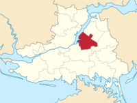
Hornostaivka Raion
| Hornostaivskyi Raion Горностаівський район | |||
|---|---|---|---|
| Raion | |||
| |||
 | |||
| Coordinates: 46°54′5.778″N 33°53′51.7626″E / 46.90160500°N 33.897711833°ECoordinates: 46°54′5.778″N 33°53′51.7626″E / 46.90160500°N 33.897711833°E | |||
| Country |
| ||
| Region | Kherson Oblast | ||
| Admin. center | Hornostaivka | ||
| Subdivisions |
List
| ||
| Area | |||
| • Total | 1,018 km2 (393 sq mi) | ||
| Population (2015) | |||
| • Total |
| ||
| Time zone | UTC+2 (EET) | ||
| • Summer (DST) | UTC+3 (EEST) | ||
| Postal index | 74600—74642 | ||
| Area code | +380 +380-5544 | ||
Hornostaivka Raion (Ukrainian: Горностаївський район) is one of the 18 administrative raions (a district) of Kherson Oblast in southern Ukraine. Its administrative center is located in the urban-type settlement of Hornostaivka. Population: 19,766 (2015 est.)[1]
References
- ↑ "Чисельність наявного населення України (Actual population of Ukraine)" (PDF) (in Ukrainian). State Statistics Service of Ukraine. Retrieved 1 July 2016.
| Raions | |||||
|---|---|---|---|---|---|
| Cities |
| ||||
| |||||
This article is issued from
Wikipedia.
The text is licensed under Creative Commons - Attribution - Sharealike.
Additional terms may apply for the media files.