Hola Prystan Raion
| Holoprystanskyi Raion Голопристанський район | |||
|---|---|---|---|
| Raion | |||
| |||
 | |||
| Coordinates: 46°16′21.1404″N 32°5′54.7728″E / 46.272539000°N 32.098548000°ECoordinates: 46°16′21.1404″N 32°5′54.7728″E / 46.272539000°N 32.098548000°E | |||
| Country |
| ||
| Region | Kherson Oblast | ||
| Established | 1923 | ||
| Admin. center | Hola Prystan | ||
| Subdivisions |
List
| ||
| Government | |||
| • Governor | Oleksandr Onoprienko | ||
| Area | |||
| • Total | 3,413 km2 (1,318 sq mi) | ||
| Population (2012) | |||
| • Total |
| ||
| Time zone | UTC+2 (EET) | ||
| • Summer (DST) | UTC+3 (EEST) | ||
| Postal index | 75600—75664 | ||
| Area code | +380 5539 | ||
| Website | http://gopriks.net | ||


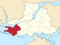
Hola Prystan Raion (Ukrainian: Голопристанський район) is one of the 18 administrative raions (a district) of Kherson Oblast in southern Ukraine. Its administrative center is located in the city of Hola Prystan, which is incorporated separately as a city of oblast significance and does not belong to the raion. Population: 45,778 (2015 est.)[1]
The raion is subdivided into 21 rural communities known as silrada that include 46 villages and 6 rural settlements.
References
- ↑ "Чисельність наявного населення України (Actual population of Ukraine)" (PDF) (in Ukrainian). State Statistics Service of Ukraine. Retrieved 1 July 2016.
| Raions | |||||
|---|---|---|---|---|---|
| Cities |
| ||||
| |||||
This article is issued from
Wikipedia.
The text is licensed under Creative Commons - Attribution - Sharealike.
Additional terms may apply for the media files.