Hohnstein
| Hohnstein | ||
|---|---|---|
.jpg) | ||
| ||
 Hohnstein Location of Hohnstein within Sächsische Schweiz-Osterzgebirge district 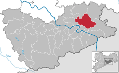  | ||
| Coordinates: 50°59′N 14°07′E / 50.983°N 14.117°ECoordinates: 50°59′N 14°07′E / 50.983°N 14.117°E | ||
| Country | Germany | |
| State | Saxony | |
| District | Sächsische Schweiz-Osterzgebirge | |
| Government | ||
| • Mayor | Sebastian Brade (UWU) | |
| Area | ||
| • Total | 64.61 km2 (24.95 sq mi) | |
| Elevation | 330 m (1,080 ft) | |
| Population (2017-12-31)[1] | ||
| • Total | 3,297 | |
| • Density | 51/km2 (130/sq mi) | |
| Time zone | CET/CEST (UTC+1/+2) | |
| Postal codes | 01848 | |
| Dialling codes | 035975 | |
| Vehicle registration | PIR | |
| Website | www.hohnstein.de | |
_Wappen.png)
Hohnstein is a town in the Sächsische Schweiz-Osterzgebirge district, in the Free State of Saxony, Germany. As of 2010 its population was of 3,671.
Geography
It is situated in Saxon Switzerland, 12 km east of Pirna, and 28 km southeast of Dresden (centre). It is dominated by its castle, standing on a sandstone rock.
Municipal territory includes the villages (Ortsteil) of Cunnersdorf, Ehrenberg, Goßdorf, Lohsdorf, Rathewalde, Ulbersdorf and Waitzdorf.
Gallery
_1985%2C_MiNr_2976.jpg) 1985 stamp of the castle.
1985 stamp of the castle.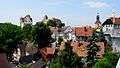 View of the town and the castle.
 Town's church
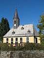 Church in Rathewalde
 The Amsel Falls near Rathewalde
See also
References
- ↑ "Aktuelle Einwohnerzahlen nach Gemeinden 2017] (Einwohnerzahlen auf Grundlage des Zensus 2011)" (PDF). Statistisches Landesamt des Freistaates Sachsen (in German). October 2018.
External links
![]()
This article is issued from
Wikipedia.
The text is licensed under Creative Commons - Attribution - Sharealike.
Additional terms may apply for the media files.