Rosenthal-Bielatal
| Rosenthal-Bielatal | ||
|---|---|---|
| ||
 Rosenthal-Bielatal Location of Rosenthal-Bielatal within Sächsische Schweiz-Osterzgebirge district 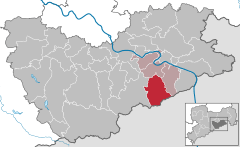  | ||
| Coordinates: 50°52′N 14°03′E / 50.867°N 14.050°ECoordinates: 50°52′N 14°03′E / 50.867°N 14.050°E | ||
| Country | Germany | |
| State | Saxony | |
| District | Sächsische Schweiz-Osterzgebirge | |
| Municipal assoc. | Königstein/Sächs. Schweiz | |
| Government | ||
| • Mayor | Bernd Gottschald | |
| Area | ||
| • Total | 46.45 km2 (17.93 sq mi) | |
| Elevation | 408 m (1,339 ft) | |
| Population (2017-12-31)[1] | ||
| • Total | 1,608 | |
| • Density | 35/km2 (90/sq mi) | |
| Time zone | CET/CEST (UTC+1/+2) | |
| Postal codes | 01824 | |
| Dialling codes | 035033 | |
| Vehicle registration | PIR | |
| Website | www.rosenthal-bielatal.de | |
Rosenthal-Bielatal is a municipality in the Sächsische Schweiz-Osterzgebirge district, in Saxony, Germany.
References
- ↑ "Aktuelle Einwohnerzahlen nach Gemeinden 2017] (Einwohnerzahlen auf Grundlage des Zensus 2011)" (PDF). Statistisches Landesamt des Freistaates Sachsen (in German). October 2018.
This article is issued from
Wikipedia.
The text is licensed under Creative Commons - Attribution - Sharealike.
Additional terms may apply for the media files.