Þjórsá
| Designations | |
|---|---|
| Official name | Thjörsárver |
| Designated | 20 March 1990 |
| Reference no. | 460[1] |
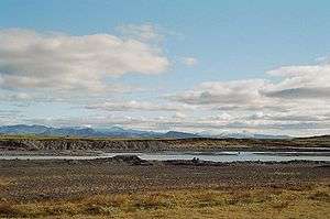
Þjórsá (Icelandic pronunciation: [ˈθjoursau]) is Iceland's longest river at 230 kilometers (about 143 miles). It is in the south of the island.
Þjórsá is a glacier river and has its source on the glacier Hofsjökull. It flows out through narrow gorges in the highlands of Iceland. Further downstream, another river, the Tungnaá, flows into it (see also Háifoss), before it enters the lowlands. There it passes the valley of Þjórsárdalur (Thjorsardalur) where the historical farm of Stöng is located at 64°7′12″N 19°49′13″W / 64.12000°N 19.82028°W. In the lowlands it flows along the eastern border of the Great Þjórsá Lava.
In the middle of the now rather wide river, there is a big island called Árnes, where there used to be a Þing. The administrative unit of Árnessýsla was named after it.
The hringvegur (Road No.1) traverses the river via a bridge between Selfoss and Hella. Some kilometers to the southwest the river flows into the Atlantic Ocean.
'Á' signifies river while 'þjór' means bull and is cognate to Danish - tyr, Swedish - tjur and Latin - taurus.
See also
References
- ↑ "Thjörsárver". Ramsar Sites Information Service. Retrieved 25 April 2018.
External links
